
Urbn Edge
3510 Union St,
Flushing, NY 11354
$3,050 - $4,200 Total Monthly Price
1-2 Beds 12 Month Lease
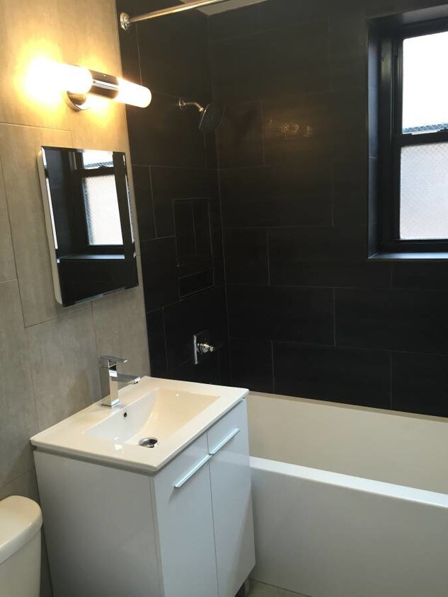
Brand New Renovation! BE THE FIRST TO OCCUPY THE APARTMENT NYC Style living in Queens All TRANSIT just steps away FABULOUS GRANITE CHEFS KITCHEN Stainless Steel Appliances Dishwasher & Microwave Includes free mounted 32' Flat Screen TV
133-17 Sanford avenue is an apartment community located in Queens County and the 11355 ZIP Code. This area is served by the New York City Geographic District #25 attendance zone.
Unique Features
Instalaciones de lavandería
Ascensor
Property manager en las instalaciones
Comercio minorista en las instalaciones
Flushing is one of Queens' most commercially active neighborhoods, home to the fourth-largest central business district in all of New York City. Its core intersection at Main Street and Roosevelt Avenue ranks among the busiest in the city, and the energy that radiates outward from there reflects just how much this neighborhood has to offer. Anchored by Queens Botanical Garden and the sprawling Flushing Meadows–Corona Park, the area balances dense urban activity with genuine green space. The New York Mets call this neighborhood home at Citi Field, and USTA Billie Jean King National Tennis Center hosts the U.S. Open each summer nearby. Flushing dates to 1645, making it one of the oldest settlements in the region, and that deep history gives the neighborhood a sense of permanence that newer developments can't replicate.
Learn more about living in FlushingCompare neighborhood and city base rent averages by bedroom.
| Downtown Flushing | Flushing, NY | |
|---|---|---|
| Studio | $1,654 | $1,768 |
| 1 Bedroom | $2,298 | $2,052 |
| 2 Bedrooms | $2,695 | $2,472 |
| 3 Bedrooms | $3,054 | $2,865 |
| Colleges & Universities | Distance | ||
|---|---|---|---|
| Colleges & Universities | Distance | ||
| Drive: | 5 min | 1.8 mi | |
| Drive: | 10 min | 4.3 mi | |
| Drive: | 11 min | 5.6 mi | |
| Drive: | 10 min | 6.0 mi |


Transportation options available in Flushing include Flushing-Main Street, located 0.3 mile from 133-17 Sanford avenue. 133-17 Sanford avenue is near LaGuardia, located 3.7 miles or 9 minutes away, and John F Kennedy International, located 9.8 miles or 14 minutes away.
| Transit / Subway | Distance | ||
|---|---|---|---|
| Transit / Subway | Distance | ||
|
|
Walk: | 5 min | 0.3 mi |
|
|
Walk: | 20 min | 1.0 mi |
|
|
Drive: | 3 min | 1.7 mi |
|
|
Drive: | 4 min | 2.0 mi |
|
|
Drive: | 5 min | 2.4 mi |
| Commuter Rail | Distance | ||
|---|---|---|---|
| Commuter Rail | Distance | ||
|
|
Walk: | 5 min | 0.3 mi |
|
|
Drive: | 4 min | 1.1 mi |
|
|
Drive: | 4 min | 1.6 mi |
|
|
Drive: | 5 min | 2.6 mi |
|
|
Drive: | 7 min | 3.3 mi |
| Airports | Distance | ||
|---|---|---|---|
| Airports | Distance | ||
|
LaGuardia
|
Drive: | 9 min | 3.7 mi |
|
John F Kennedy International
|
Drive: | 14 min | 9.8 mi |
Scores provided by
Traffic
-Airport
-Businesses
-Scores provided by
HowLoud What is a Sound Score Rating? A Sound Score Rating aggregates noise caused by vehicle traffic, airplane traffic and local sources. How It WorksTime and distance from 133-17 Sanford avenue.
| Shopping Centers | Distance | ||
|---|---|---|---|
| Shopping Centers | Distance | ||
| Walk: | 11 min | 0.6 mi | |
| Walk: | 17 min | 0.9 mi | |
| Drive: | 3 min | 1.4 mi |
| Parks and Recreation | Distance | ||
|---|---|---|---|
| Parks and Recreation | Distance | ||
|
Queens Botanical Garden
|
Walk: | 11 min | 0.6 mi |
|
Flushing Meadows Corona Park
|
Drive: | 4 min | 1.5 mi |
|
Kissena Park
|
Drive: | 5 min | 1.9 mi |
|
Queens Zoo
|
Drive: | 5 min | 2.2 mi |
|
New York Hall of Science
|
Drive: | 5 min | 2.2 mi |
| Hospitals | Distance | ||
|---|---|---|---|
| Hospitals | Distance | ||
| Drive: | 3 min | 1.1 mi | |
| Drive: | 8 min | 3.5 mi | |
| Drive: | 8 min | 4.0 mi |
| Military Bases | Distance | ||
|---|---|---|---|
| Military Bases | Distance | ||
| Drive: | 11 min | 5.6 mi | |
| Drive: | 28 min | 14.1 mi |
What Are Walk Score®, Transit Score®, and Bike Score® Ratings?
Walk Score® measures the walkability of any address. Transit Score® measures access to public transit. Bike Score® measures the bikeability of any address.
What is a Sound Score Rating?
A Sound Score Rating aggregates noise caused by vehicle traffic, airplane traffic and local sources.

13317 Sanford Ave
Flushing, NY 11355


