
$2,500
/ Month
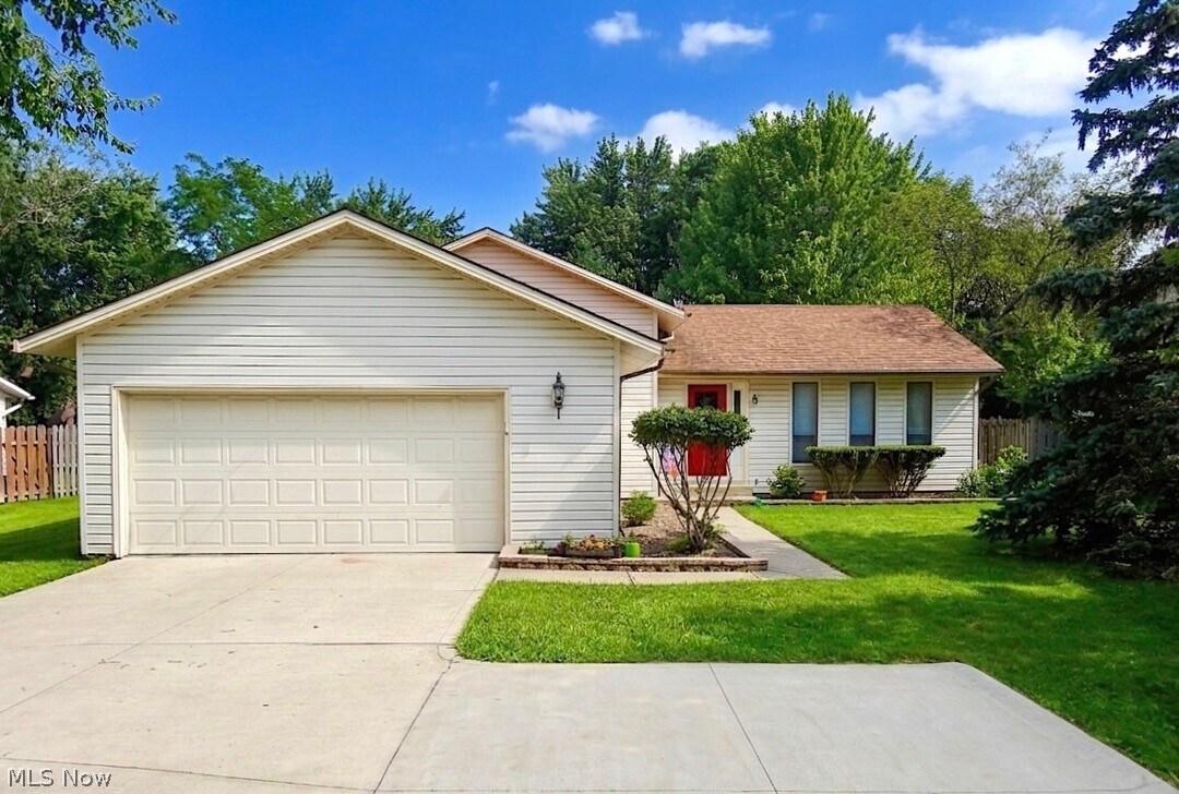
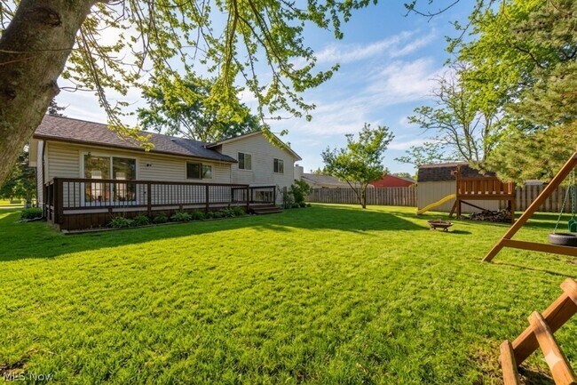
13286 Boston Rd
Strongsville, OH 44136
Favorites
440-387-1951
-
Bedrooms
3
-
Bathrooms
1.5
-
Square Feet
--
-
Available
Available Now
Highlights
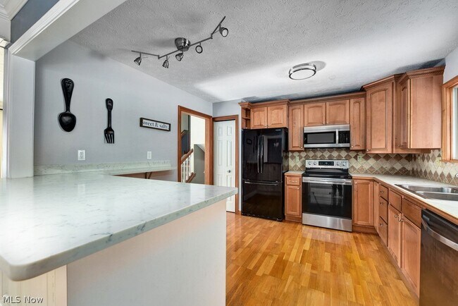
- Granite Countertops
- Eat-In Kitchen
- Woodwork
- Cooling System Mounted In Outer Wall Opening
- Laundry Room
- Forced Air Heating and Cooling System
13286 Boston Rd

Favorites
About This Home
Available Now
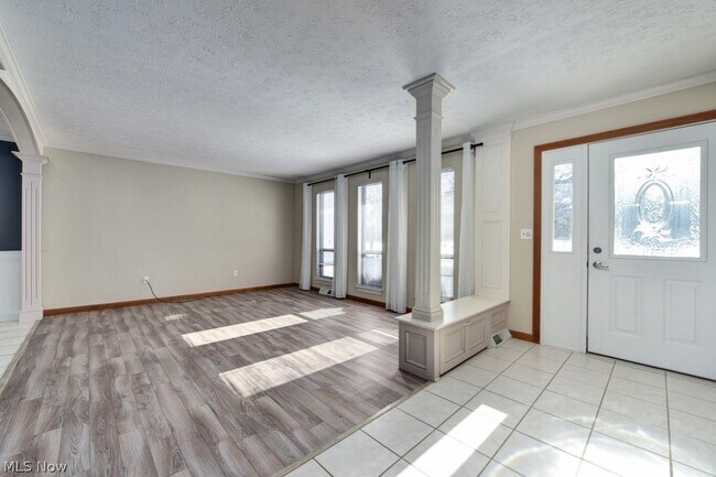
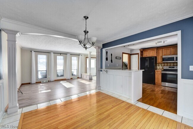
This home is conveniently located in the Strongsville City School District,close to amenities with a spacious home and yard. There is a play set,a deck,a formal dining room,a kitchen with an island,plus a living room on the main level. The half staircase upstairs leads to a full bathroom with a tub with access to the primary bedroom from the bathroom. The upstairs also provides two additional bedrooms. Downstairs there is a partially finished basement with a half bathroom as well as a partially unfinished portion with your laundry and storage room. Tenant pays all utilities and must submit an application and application fee.
13286 Boston Rd is a house located in Cuyahoga County and the 44136 ZIP Code. This area is served by the Strongsville City School District attendance zone.
* Price shown is base rent. Excludes user-selected optional fees and variable or usage-based fees and required charges due at or prior to move-in or at move-out. Price, availability, fees, and any applicable rent special are subject to change without notice.
* Square footage definitions vary. Displayed square footage is approximate.
Home Details
Home Type
Single Family Detached Home
Year Built
Built in 1977 | Remodeled
Bedrooms and Bathrooms
1.5 Bathrooms
3 Bedrooms
Home Design
Split Level Home
Block Foundation
Interior Spaces
Woodwork
1,864 Sq Ft Home
2-Story Property
Kitchen
Granite Countertops
Eat-In Kitchen
Range
Microwave
Dishwasher
Laundry
Laundry Room
Listing and Financial Details
12 Month Lease Term
Assessor Parcel Number 399-33-077
Tenant pays for all utilities
Lot Details
13,874 Sq Ft Lot
Outdoor Features
Playground
Parking
2 Car Garage
Driveway
Partially Finished Basement
Laundry in Basement
Crawl Space
Utilities
Cooling System Mounted In Outer Wall Opening
Forced Air Heating and Cooling System
Community Details
Overview
Whispering Orchard Subdivision
Pet Policy
Dogs and Cats Allowed
Limit on the number of pets
Pet Size Limit
Contact
- Listed by Chelsea Soyko | RE/MAX Above & Beyond
- Phone Number
- Contact
-
Source
 MLS Now
Copyright 2026 © MLS Now. All rights reserved.
Location
Get Directions
Strongsville earns its nickname, Crossroads of the Nation, from the spot where Interstate 71 meets the Ohio Turnpike, making this Cuyahoga County suburb one of the better-connected communities in northeast Ohio. Sitting about 20 miles southwest of Cleveland, the city covers roughly 25 square miles and carries a settled, self-sufficient character that draws people looking for both breathing room and easy access to a major metro. The Cleveland Clinic's presence here anchors a strong employment base, while SouthPark Mall and the retail corridors along Pearl and Royalton Roads keep most everyday needs close to home.
The housing mix leans residential, with established single-family neighborhoods making up much of the landscape. Renters will find apartment communities and townhome-style rentals scattered throughout the city, offering options that range from garden-style units to more spacious multi-bedroom layouts.
Learn more about living in Strongsville
Education
| Colleges & Universities | Distance | ||
|---|---|---|---|
| Colleges & Universities | Distance | ||
| Drive: | 8 min | 4.5 mi | |
| Drive: | 17 min | 8.2 mi | |
| Drive: | 17 min | 9.4 mi | |
| Drive: | 30 min | 18.7 mi |
13286 Boston Rd is within 8 minutes or 4.5 miles from Cuyahoga C.C., Brunswick. It is also near Cuyahoga C.C., Western Campus and Baldwin - Wallace College.
Schools


Public Elementary School
Grades PK-5
440 Students
Attendance Zone
Public High School
Grades 9-12
1,677 Students
Attendance Zone
Private Elementary & Middle School
Grades PK-8
336 Students
Nearby
Private Elementary, Middle & High School
Grades PK-12
69 Students
Nearby
School data provided by
 The GreatSchools Rating helps parents compare schools within a state based on a variety of school quality indicators and provides a helpful picture of how effectively each school serves all of its students. Ratings are on a scale of 1 (below average) to 10 (above average) and can include test scores, college readiness, academic progress, advanced courses, equity, discipline and attendance data. We also advise parents to visit schools, consider other information on school performance and programs, and consider family needs as part of the school selection process.
View GreatSchools Rating Methodology
Data provided by GreatSchools.org © 2026. All rights reserved.
View GreatSchools Rating Methodology
Data provided by GreatSchools.org © 2026. All rights reserved.
Transportation options available in Strongsville include Airport Station, located 12.1 miles from 13286 Boston Rd. 13286 Boston Rd is near Cleveland-Hopkins International, located 13.9 miles or 25 minutes away, and Akron-Canton Regional, located 39.2 miles or 55 minutes away.
| Transit / Subway | Distance | ||
|---|---|---|---|
| Transit / Subway | Distance | ||
| Drive: | 20 min | 12.1 mi |
| Commuter Rail | Distance | ||
|---|---|---|---|
| Commuter Rail | Distance | ||
| Drive: | 25 min | 12.0 mi | |
| Drive: | 28 min | 14.2 mi | |
|
Boston Mill
|
Drive: | 29 min | 15.9 mi |
| Drive: | 30 min | 16.0 mi | |
| Drive: | 29 min | 16.1 mi |
| Airports | Distance | ||
|---|---|---|---|
| Airports | Distance | ||
|
Cleveland-Hopkins International
|
Drive: | 25 min | 13.9 mi |
|
Akron-Canton Regional
|
Drive: | 55 min | 39.2 mi |
Getting Around
 What do Walkability, Transit, Drivability, and Bikeability mean?
Walkability measures the walking distance to day-to-day needs.
Transit measures access to public transportation.
Drivability measures congestion, parking availability, and access to major roads.
Bikeability measures the suitability for cycling.
How It Works
What do Walkability, Transit, Drivability, and Bikeability mean?
Walkability measures the walking distance to day-to-day needs.
Transit measures access to public transportation.
Drivability measures congestion, parking availability, and access to major roads.
Bikeability measures the suitability for cycling.
How It Works
Fairly Walkable
Walkability
40
/ 100
Minimal Public Transit
Transit
0
/ 100
Exceptionally Drivable
Drivability
90
/ 100
Fairly Bikeable
Bikeability
50
/ 100
Scores provided by
Active
Soundscore™
76
/ 100
Traffic
BusyAirport
CalmBusinesses
ActiveScores provided by
HowLoud What is a Sound Score Rating? A Sound Score Rating aggregates noise caused by vehicle traffic, airplane traffic and local sources. How It WorksTime and distance from 13286 Boston Rd.
| Shopping Centers | Distance | ||
|---|---|---|---|
| Shopping Centers | Distance | ||
| Walk: | 2 min | 0.1 mi | |
| Walk: | 6 min | 0.3 mi | |
| Drive: | 7 min | 2.8 mi |
13286 Boston Rd has 3 shopping centers within 2.8 miles, which is about a 7-minute drive. The miles and minutes will be for the farthest away property.
| Parks and Recreation | Distance | ||
|---|---|---|---|
| Parks and Recreation | Distance | ||
|
Mill Stream Run Reservation
|
Drive: | 5 min | 3.0 mi |
|
Princess Ledges Nature Preserve
|
Drive: | 7 min | 3.4 mi |
|
Gardenview Horticultural Park
|
Drive: | 8 min | 4.0 mi |
|
Susan Hambley Nature Center
|
Drive: | 8 min | 4.5 mi |
|
Plum Creek Park
|
Drive: | 12 min | 5.8 mi |
13286 Boston Rd has 5 parks within 5.8 miles, including Mill Stream Run Reservation, Princess Ledges Nature Preserve, and Gardenview Horticultural Park.
| Hospitals | Distance | ||
|---|---|---|---|
| Hospitals | Distance | ||
| Drive: | 14 min | 8.7 mi | |
| Drive: | 17 min | 8.8 mi | |
| Drive: | 19 min | 12.9 mi |
13286 Boston Rd has 3 hospitals within 12.9 miles, the nearest is Southwest General Health Center which is 8.7 miles away and a 14 minute drive.
| Military Bases | Distance | ||
|---|---|---|---|
| Military Bases | Distance | ||
| Drive: | 74 min | 62.2 mi | |
| Drive: | 105 min | 80.2 mi |
13286 Boston Rd is 62.2 miles from Mansfield Lahm Airport Air Guard Station, and is convenient to other military bases, including Camp Perry Air Guard Station.
You May Also Like
Similar Rentals Nearby


13286 Boston Rd
Strongsville, OH 44136