$5,500 / Month
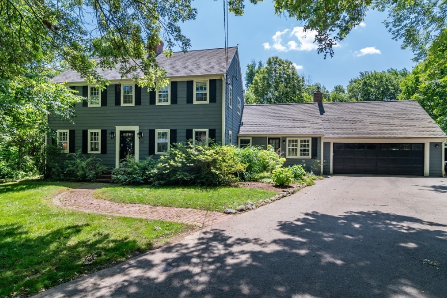
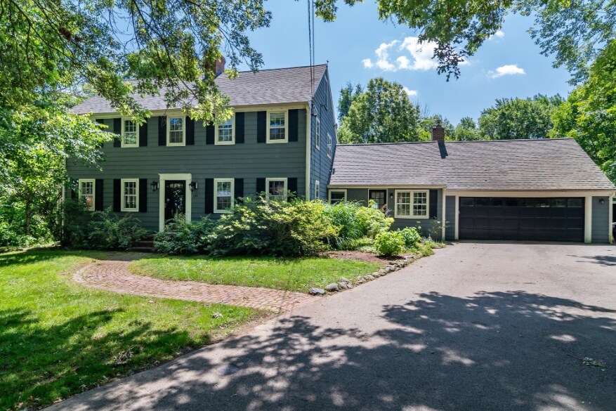
132 Pelham Island Rd
Wayland, MA 01778
Today
Favorites
-
Bedrooms
3
-
Bathrooms
2.5
-
Square Feet
2,832 sq ft
-
Available
Available Sep 1
Highlights
- Pets Allowed
- Furnished
- Patio
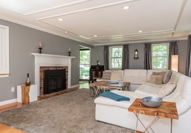
- Fireplace
132 Pelham Island Rd

Favorites
About This Home
12 Month Lease
,
Available Sep 1
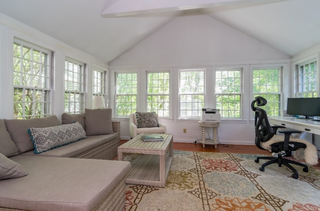
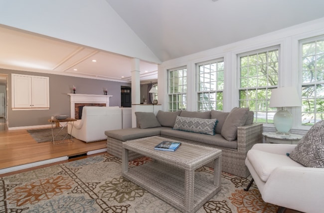
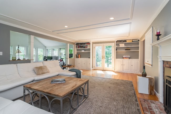
Offered fully furnished, this home features thoughtfully designed living space with 3 generously sized bedrooms and multiple gathering areas, including a formal living room with a fireplace, a sunlit dining room, and a cozy family room perfect for everyday living. The updated kitchen offers ample cabinet space, modern appliances, and direct access to a spacious patio overlooking the peaceful, private backyard. Set on a beautifully landscaped lot with mature plantings, this home provides tranquil outdoor living while being just minutes from major commuter routes, schools, and local amenities.
132 Pelham Island Rd is a house located in Middlesex County and the 01778 ZIP Code.
* Price shown is base rent and may not include non-optional fees and utilities.
Price, availability, fees, and any applicable rent special are subject to change without notice.
* Square footage definitions vary. Displayed square footage is approximate.
House Features
Washer/Dryer
Fireplace
Furnished
Dining Room
- Washer/Dryer
- Fireplace
- Kitchen
- Dining Room
- Family Room
- Furnished
- Furnished Units Available
- Patio
Fees and Policies
The fees below are based on community-supplied data and may exclude additional fees and utilities.
- Dogs Allowed
-
Fees not specified
- Cats Allowed
-
Fees not specified
Details
Property Information
-
Furnished Units Available
Contact
- Contact
Location
Get Directions
Just west of Boston and East of Worcester sits Metro West, a region that houses a group of towns and cities with significant historical backgrounds. A total of 19 municipalities make up the core of this community, but other municipalities are considered to be a part of the Interstate 495/Metro West Corridor.
Learn more about living in Metro West
Education
| Colleges & Universities | Distance | ||
|---|---|---|---|
| Colleges & Universities | Distance | ||
| Drive: | 14 min | 6.8 mi | |
| Drive: | 16 min | 7.8 mi | |
| Drive: | 18 min | 8.6 mi | |
| Drive: | 19 min | 10.3 mi |
132 Pelham Island Rd is within 16 minutes or 7.8 miles from Brandeis University. It is also near Framingham State College and Wellesley College.
Transportation options available in Wayland include Riverside Station, located 9.1 miles from 132 Pelham Island Rd. 132 Pelham Island Rd is near General Edward Lawrence Logan International, located 22.8 miles or 36 minutes away, and Worcester Regional, located 32.6 miles or 52 minutes away.
| Transit / Subway | Distance | ||
|---|---|---|---|
| Transit / Subway | Distance | ||
|
|
Drive: | 16 min | 9.1 mi |
|
|
Drive: | 16 min | 9.4 mi |
|
|
Drive: | 17 min | 10.1 mi |
|
|
Drive: | 20 min | 11.7 mi |
|
|
Drive: | 20 min | 11.9 mi |
| Commuter Rail | Distance | ||
|---|---|---|---|
| Commuter Rail | Distance | ||
|
|
Drive: | 10 min | 5.4 mi |
|
|
Drive: | 10 min | 5.6 mi |
| Drive: | 12 min | 5.8 mi | |
|
|
Drive: | 11 min | 6.5 mi |
|
|
Drive: | 15 min | 7.9 mi |
| Airports | Distance | ||
|---|---|---|---|
| Airports | Distance | ||
|
General Edward Lawrence Logan International
|
Drive: | 36 min | 22.8 mi |
|
Worcester Regional
|
Drive: | 52 min | 32.6 mi |
Time and distance from 132 Pelham Island Rd.
| Shopping Centers | Distance | ||
|---|---|---|---|
| Shopping Centers | Distance | ||
| Drive: | 3 min | 1.3 mi | |
| Drive: | 7 min | 3.0 mi | |
| Drive: | 7 min | 3.1 mi |
132 Pelham Island Rd has 3 shopping centers within 3.1 miles, which is about a 7-minute drive. The miles and minutes will be for the farthest away property.
| Parks and Recreation | Distance | ||
|---|---|---|---|
| Parks and Recreation | Distance | ||
|
Greenways Conservation Area
|
Drive: | 3 min | 1.8 mi |
|
Upper Mill Brook Conservation Area
|
Drive: | 3 min | 1.8 mi |
|
Wolbach Farm
|
Drive: | 6 min | 2.9 mi |
|
Hazel Brook Conservation Area
|
Drive: | 6 min | 3.1 mi |
|
Hamlen Woods
|
Drive: | 7 min | 3.4 mi |
132 Pelham Island Rd has 5 parks within 3.4 miles, including Upper Mill Brook Conservation Area, Greenways Conservation Area, and Wolbach Farm.
| Hospitals | Distance | ||
|---|---|---|---|
| Hospitals | Distance | ||
| Drive: | 13 min | 7.1 mi | |
| Drive: | 15 min | 7.9 mi | |
| Drive: | 17 min | 9.1 mi |
132 Pelham Island Rd has 3 hospitals within 9.1 miles, the nearest is Walden Behavioral Care which is 7.1 miles away and a 13 minute drive.
| Military Bases | Distance | ||
|---|---|---|---|
| Military Bases | Distance | ||
| Drive: | 10 min | 6.2 mi | |
| Drive: | 21 min | 10.8 mi |
132 Pelham Island Rd is 6.2 miles from US Military Reservation, and is convenient to other military bases, including Hanscom Air Force Base.
Amenities
- Washer/Dryer
- Fireplace
- Kitchen
- Dining Room
- Family Room
- Furnished
- Furnished Units Available
- Patio
132 Pelham Island Rd Photos
What Are Walk Score®, Transit Score®, and Bike Score® Ratings?
Walk Score® measures the walkability of any address. Transit Score® measures access to public transit. Bike Score® measures the bikeability of any address.
What is a Sound Score Rating?
A Sound Score Rating aggregates noise caused by vehicle traffic, airplane traffic and local sources
132 Pelham Island Rd
Wayland, MA 01778