$3,500 / Month
132 Loucks Ave Unit A
Los Altos, CA 94022
2 Weeks Ago
Favorites
132 Loucks Ave Unit A

Favorites
Check Back Soon for Upcoming Availability
| Beds | Baths | Average SF |
|---|---|---|
| 1 Bedroom 1 Bedroom 1 Br | 1 Bath 1 Bath 1 Ba | 500 SF |
Fees and Policies
The fees below are based on community-supplied data and may exclude additional fees and utilities.
- Parking
-
Street--
Details
Utilities Included
-
Gas
-
Water
-
Electricity
-
Heat
-
Sewer
-
Air Conditioning
Property Information
-
Furnished Units Available
About This Property
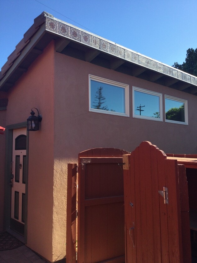
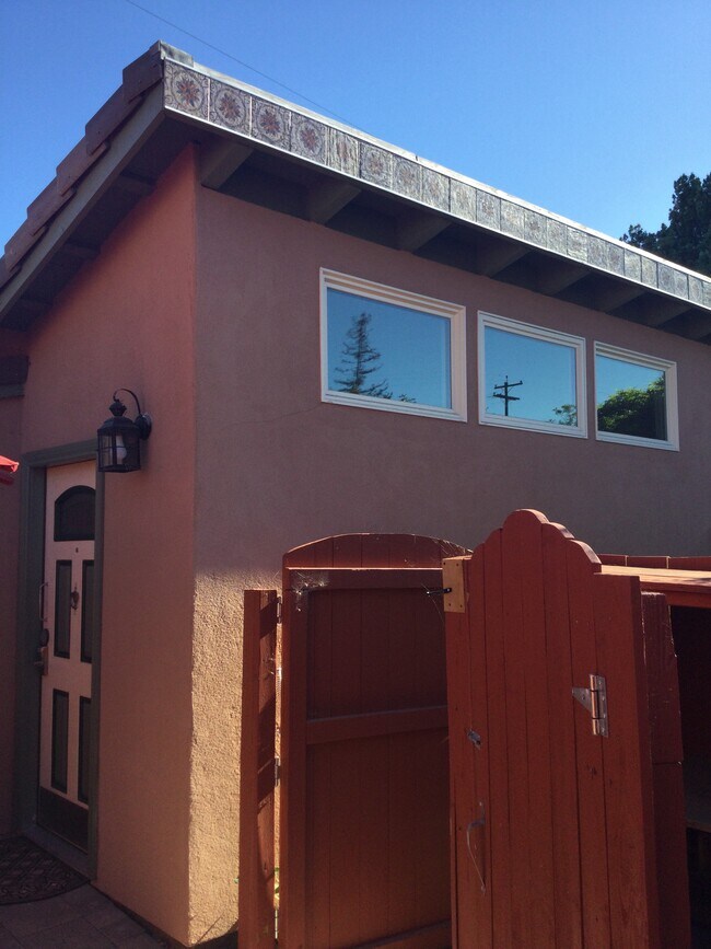
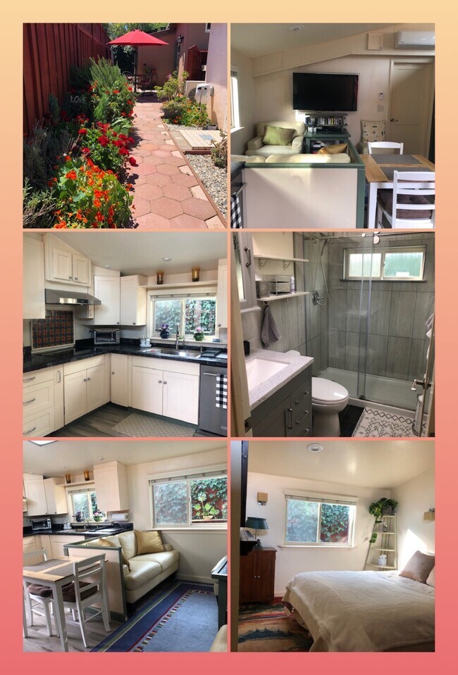
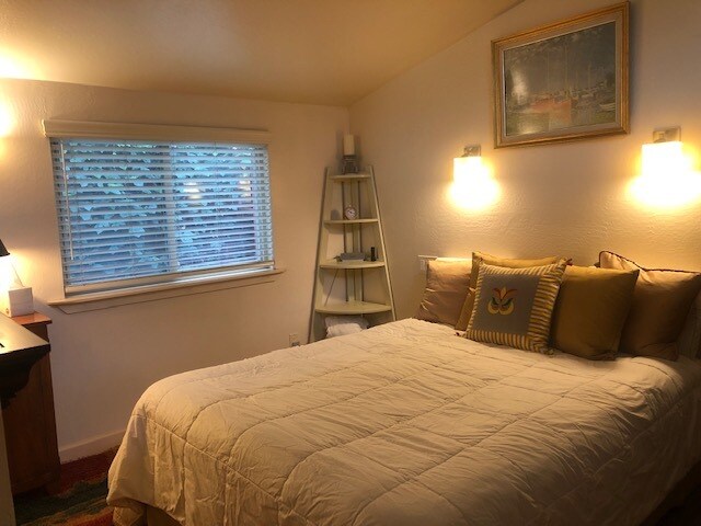
This is a 1-bedroom furnished recently constructed ADU (Adjacent Dwelling Unit) cottage in the garden of a large home in residential north Los Altos. This isolated luxurious 500 sq ft home offers exceptional security, privacy and tranquility. The $3500/month rent includes electricity, water, and sewage (there are no gas appliances in the house.) The ADU has separate access through a side gate, and it is wheelchair accessible. There is a private patio with barbeque. It is available now for a 12 month lease. Quiet residential neighborhood in lovely Los Altos, near shopping, transportation, Stanford University.
132 Loucks Ave is an apartment community located in Santa Clara County and the 94022 ZIP Code.
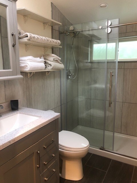
Apartment Features
Washer/Dryer
Air Conditioning
Dishwasher
Microwave
- Washer/Dryer
- Air Conditioning
- Heating
- Smoke Free
- Cable Ready
- Wheelchair Accessible (Rooms)
- Dishwasher
- Disposal
- Ice Maker
- Eat-in Kitchen
- Kitchen
- Microwave
- Refrigerator
- Carpet
- Tile Floors
- Vaulted Ceiling
- Furnished
- Furnished Units Available
- Wheelchair Accessible
- Gated
- Patio
- Yard
- Grill
- Garden
Location
Get Directions
North Los Altos contains the city’s vibrant commercial centers. The many shops and eateries of Main Street are in the southern portion of North Los Altos, while the diverse restaurants and cafes of San Antonio Road are in the northern stretches near San Antonio Center.
Outside of these commercial areas, North Los Altos is predominantly residential, offering an array of apartments available for rent along tree-lined avenues. Many of the rentals in North Los Altos feature stunning mountain views, as well as close proximity to Mountain View, Foothill College, Stanford University, and Palo Alto. Getting around from North Los Altos is simple with access to El Camino Real, Interstate 280, and San Antonio Station.
Learn more about living in North Los AltosBelow are rent ranges for similar nearby apartments
Amenities
- Washer/Dryer
- Air Conditioning
- Heating
- Smoke Free
- Cable Ready
- Wheelchair Accessible (Rooms)
- Dishwasher
- Disposal
- Ice Maker
- Eat-in Kitchen
- Kitchen
- Microwave
- Refrigerator
- Carpet
- Tile Floors
- Vaulted Ceiling
- Furnished
- Furnished Units Available
- Wheelchair Accessible
- Gated
- Patio
- Yard
- Grill
- Garden
Expenses
Utilities Included
Gas, Water, Electricity, Heat, Sewer, Air Conditioning
Included
Education
| Colleges & Universities | Distance | ||
|---|---|---|---|
| Colleges & Universities | Distance | ||
| Drive: | 5 min | 1.8 mi | |
| Drive: | 8 min | 3.6 mi | |
| Drive: | 11 min | 4.2 mi | |
| Drive: | 15 min | 6.5 mi |
132 Loucks Ave Unit A is within 5 minutes or 1.8 miles from Foothill College, Middlefield. It is also near Foothill Coll., Los Altos and Stanford University.
Transportation options available in Los Altos include Mountain View Station, located 2.7 miles from 132 Loucks Ave Unit A. 132 Loucks Ave Unit A is near Norman Y Mineta San Jose International, located 12.2 miles or 19 minutes away, and San Francisco International, located 24.5 miles or 33 minutes away.
| Transit / Subway | Distance | ||
|---|---|---|---|
| Transit / Subway | Distance | ||
| Drive: | 5 min | 2.7 mi | |
|
|
Drive: | 5 min | 2.7 mi |
| Drive: | 8 min | 4.0 mi | |
| Drive: | 9 min | 4.7 mi | |
| Drive: | 10 min | 4.7 mi |
| Commuter Rail | Distance | ||
|---|---|---|---|
| Commuter Rail | Distance | ||
| Walk: | 19 min | 1.0 mi | |
| Drive: | 7 min | 2.9 mi | |
| Drive: | 8 min | 3.1 mi | |
| Drive: | 7 min | 3.1 mi | |
| Drive: | 8 min | 3.3 mi |
| Airports | Distance | ||
|---|---|---|---|
| Airports | Distance | ||
|
Norman Y Mineta San Jose International
|
Drive: | 19 min | 12.2 mi |
|
San Francisco International
|
Drive: | 33 min | 24.5 mi |
Time and distance from 132 Loucks Ave Unit A.
| Shopping Centers | Distance | ||
|---|---|---|---|
| Shopping Centers | Distance | ||
| Walk: | 7 min | 0.4 mi | |
| Walk: | 9 min | 0.5 mi | |
| Walk: | 10 min | 0.5 mi |
132 Loucks Ave Unit A has 3 shopping centers within 0.5 mile, which is about a 10-minute walk. The miles and minutes will be for the farthest away property.
| Parks and Recreation | Distance | ||
|---|---|---|---|
| Parks and Recreation | Distance | ||
|
Terman Park
|
Drive: | 5 min | 1.8 mi |
|
J. Pearce Mitchell Park
|
Drive: | 7 min | 2.4 mi |
|
Redwood Grove
|
Drive: | 6 min | 2.5 mi |
|
Bol Park
|
Drive: | 7 min | 2.7 mi |
|
Esther Clark Nature Preserve
|
Drive: | 8 min | 2.8 mi |
132 Loucks Ave Unit A has 5 parks within 2.8 miles, including Terman Park, Esther Clark Nature Preserve, and Bol Park.
| Hospitals | Distance | ||
|---|---|---|---|
| Hospitals | Distance | ||
| Drive: | 8 min | 3.6 mi | |
| Drive: | 12 min | 4.9 mi | |
| Drive: | 14 min | 5.5 mi |
132 Loucks Ave Unit A has 3 hospitals within 5.5 miles, the nearest is El Camino Hospital which is 3.6 miles away and a 8 minute drive.
| Military Bases | Distance | ||
|---|---|---|---|
| Military Bases | Distance | ||
| Drive: | 12 min | 5.0 mi |
132 Loucks Ave Unit A is 5.0 miles and a 12 minute drive from Ames Research Center.
You May Also Like
Similar Rentals Nearby


What Are Walk Score®, Transit Score®, and Bike Score® Ratings?
Walk Score® measures the walkability of any address. Transit Score® measures access to public transit. Bike Score® measures the bikeability of any address.
What is a Sound Score Rating?
A Sound Score Rating aggregates noise caused by vehicle traffic, airplane traffic and local sources

132 Loucks Ave
Los Altos, CA 94022