

$762 / Month
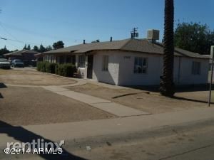
1305 W Clarendon Ave Unit Apt 1
Phoenix, AZ 85013
2 Weeks Ago
Favorites
1305 W Clarendon Ave Unit Apt 1

Favorites
Check Back Soon for Upcoming Availability
| Beds | Baths | Average SF |
|---|---|---|
| 2 Bedrooms 2 Bedrooms 2 Br | 1 Bath 1 Bath 1 Ba | 850 SF |
About This Property
(480) 990-1500 - Low Income Federal Housing Program (HUD) Great opportunity for a needy family to obtain very affordable housing though Federal Housing Program. Only ONE unit available. NO Section 8 voucher needed Monthly Rent is based on applicant income (up to 30% of applicant income) COULD BE A LOW AS $0 per month Call (please leave message if not available) or text (PREFER text) Convenient central location. 850 sf, 2 Bedroom 1 Bathroom apartment. Steps from Clarendon Elementary School. Central swamp cooled and central heating unit. Ceiling Fans No Pets Allowed (RLNE2108084) Other Amenities - Parking, Smoke Free. Appliances - Refrigerator, Range- gas, Oven, Washer & Dryer On-Site. Lease lengths - 12 Months. Details regarding this property's Utilities - Resident Pays Electricity, Resident Pays Gas, Water Included. Pet policies - No Dogs Allowed, No Cats Allowed, No Pets Allowed.
1305 W Clarendon Ave is a condo located in Maricopa County and the 85013 ZIP Code. This area is served by the Osborn Elementary District attendance zone.
Location
Get Directions
North Phoenix refers to the vast swath of land that stretches from Bethany Home Road up towards the Phoenix mountains. Bounded to the east by State Route 51 and to the west by 51st Avenue, North Phoenix is home a slew of diverse communities and neighborhoods all offering a variety of rentals ranging from the upscale to the more affordable. There are numerous golf courses and of course the mountains that offer residents a number of outdoor activities to engage in. For shopping and dining, residents head to Desert Ridge Marketplace on High Street, which is filled with upscale boutiques, nightlife hotspots, restaurants, and more. Interstate 17 and Route 101 make commuting around this desirable area simple.
Learn more about living in North PhoenixBelow are rent ranges for similar nearby apartments
| Beds | Average Size | Lowest | Typical | Premium |
|---|---|---|---|---|
| Studio Studio Studio | 558 Sq Ft | $750 | $1,453 | $1,994 |
| 1 Bed 1 Bed 1 Bed | 736-737 Sq Ft | $738 | $1,372 | $3,592 |
| 2 Beds 2 Beds 2 Beds | 1108-1109 Sq Ft | $750 | $1,836 | $8,951 |
| 3 Beds 3 Beds 3 Beds | 1554 Sq Ft | $649 | $2,575 | $9,700 |
| 4 Beds 4 Beds 4 Beds | 2051-2059 Sq Ft | $1,189 | $3,305 | $8,520 |
Expenses
Utilities Included
Water
Included
Education
| Colleges & Universities | Distance | ||
|---|---|---|---|
| Colleges & Universities | Distance | ||
| Walk: | 13 min | 0.7 mi | |
| Drive: | 9 min | 4.0 mi | |
| Drive: | 9 min | 4.1 mi | |
| Drive: | 12 min | 4.4 mi |
1305 W Clarendon Ave Unit Apt 1 is within 13 minutes or 0.7 mile from Phoenix College. It is also near Arizona State Univ., Downtown and Grand Canyon University.
Schools


Public Elementary & Middle School
Grades PK-8
665 Students
Attendance Zone
Public Elementary & Middle School
Grades PK-8
420 Students
Attendance Zone
Public Middle School
Grades 7-8
504 Students
Attendance Zone
Public High School
Grades 9-12
1,901 Students
Attendance Zone
Private Elementary & Middle School
Grades PK-8
Nearby
Private Elementary, Middle & High School
Grades K-12
Nearby
School data provided by
 The GreatSchools Rating helps parents compare schools within a state based on a variety of school quality indicators and provides a helpful picture of how effectively each school serves all of its students. Ratings are on a scale of 1 (below average) to 10 (above average) and can include test scores, college readiness, academic progress, advanced courses, equity, discipline and attendance data. We also advise parents to visit schools, consider other information on school performance and programs, and consider family needs as part of the school selection process.
View GreatSchools Rating Methodology
Data provided by GreatSchools.org © 2025. All rights reserved.
View GreatSchools Rating Methodology
Data provided by GreatSchools.org © 2025. All rights reserved.
Transportation options available in Phoenix include Indian School/Central Ave, located 1.4 miles from 1305 W Clarendon Ave Unit Apt 1. 1305 W Clarendon Ave Unit Apt 1 is near Phoenix Sky Harbor International, located 9.1 miles or 17 minutes away, and Phoenix-Mesa Gateway, located 35.9 miles or 49 minutes away.
| Transit / Subway | Distance | ||
|---|---|---|---|
| Transit / Subway | Distance | ||
|
|
Drive: | 3 min | 1.4 mi |
|
|
Drive: | 4 min | 1.6 mi |
|
|
Drive: | 4 min | 1.6 mi |
|
|
Drive: | 4 min | 1.7 mi |
|
|
Drive: | 4 min | 1.7 mi |
| Commuter Rail | Distance | ||
|---|---|---|---|
| Commuter Rail | Distance | ||
|
|
Drive: | 49 min | 37.0 mi |
| Airports | Distance | ||
|---|---|---|---|
| Airports | Distance | ||
|
Phoenix Sky Harbor International
|
Drive: | 17 min | 9.1 mi |
|
Phoenix-Mesa Gateway
|
Drive: | 49 min | 35.9 mi |
Time and distance from 1305 W Clarendon Ave Unit Apt 1.
| Shopping Centers | Distance | ||
|---|---|---|---|
| Shopping Centers | Distance | ||
| Walk: | 10 min | 0.5 mi | |
| Walk: | 12 min | 0.6 mi | |
| Walk: | 15 min | 0.8 mi |
1305 W Clarendon Ave Unit Apt 1 has 3 shopping centers within 0.8 mile, which is about a 15-minute walk. The miles and minutes will be for the farthest away property.
| Parks and Recreation | Distance | ||
|---|---|---|---|
| Parks and Recreation | Distance | ||
|
Steele Indian School Park
|
Drive: | 4 min | 1.5 mi |
|
Japanese Friendship Garden
|
Drive: | 7 min | 2.8 mi |
|
Civic Space Park
|
Drive: | 9 min | 3.8 mi |
|
Margaret T. Hance Park
|
Drive: | 9 min | 4.0 mi |
|
Desert Storm Park
|
Drive: | 12 min | 5.6 mi |
1305 W Clarendon Ave Unit Apt 1 has 5 parks within 5.6 miles, including Steele Indian School Park, Margaret T. Hance Park, and Japanese Friendship Garden.
| Hospitals | Distance | ||
|---|---|---|---|
| Hospitals | Distance | ||
| Drive: | 3 min | 1.3 mi | |
| Drive: | 6 min | 2.9 mi | |
| Drive: | 7 min | 3.1 mi |
1305 W Clarendon Ave Unit Apt 1 has 3 hospitals within 3.1 miles, the nearest is St. Joseph's Hospital and Medical Center which is 1.3 miles away and a 3 minute drive.
| Military Bases | Distance | ||
|---|---|---|---|
| Military Bases | Distance | ||
| Drive: | 17 min | 9.0 mi | |
| Drive: | 33 min | 18.0 mi | |
| Drive: | 101 min | 74.9 mi |
1305 W Clarendon Ave Unit Apt 1 has 3 military bases within 74.9 miles, the nearest is Phoenix Sky Harbor Airport Air Guard Station which is 9.0 miles away and a 17 minute drive.
You May Also Like
Similar Rentals Nearby


What Are Walk Score®, Transit Score®, and Bike Score® Ratings?
Walk Score® measures the walkability of any address. Transit Score® measures access to public transit. Bike Score® measures the bikeability of any address.
What is a Sound Score Rating?
A Sound Score Rating aggregates noise caused by vehicle traffic, airplane traffic and local sources
1305 W Clarendon Ave
Phoenix, AZ 85013