$4,800
/ Month
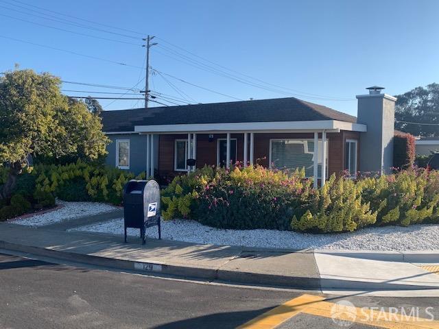
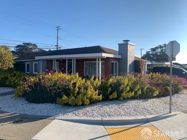
129 El Campo Dr
South San Francisco, CA 94080
2 Weeks Ago
|
Edit
Favorites
129 El Campo Dr

Favorites
Check Back Soon for Upcoming Availability
| Beds | Baths | Average SF |
|---|---|---|
| 3 Bedrooms 3 Bedrooms 3 Br | 3 Baths 3 Baths 3 Ba | 1,444 SF |
Fees and Policies
The fees below are based on community-supplied data and may exclude additional fees and utilities.
- Parking
-
Surface Lot--
-
Garage--
About This Property
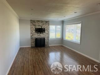
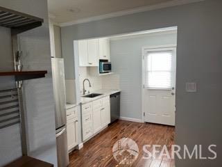
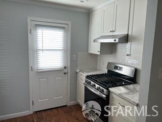
This is a single-level rancher that was fully remodeled in 2019. Great Buri-Buri neighborhood near schools.
129 El Campo Dr is a house located in San Mateo County and the 94080 ZIP Code. This area is served by the South San Francisco Unified attendance zone.
House Features
Air Conditioning
Hardwood Floors
Tub/Shower
Smoke Free
- Air Conditioning
- Smoke Free
- Tub/Shower
- Sprinkler System
- Oven
- Range
- Breakfast Nook
- Hardwood Floors
- Carpet
- Patio
Location
Get Directions
South San Francisco, known locally as "South City," sits between San Bruno Mountain and San Francisco Bay. Once an industrial center, it's now home to numerous biotechnology companies. The rental market offers options at various price points, with average rents ranging from $2,432 for studios to $4,068 for three-bedroom apartments.
The city's downtown along Grand Avenue features independent shops and local eateries that contribute to its community atmosphere. Sign Hill Park, home to the historic "South San Francisco The Industrial City" sign, provides hiking trails with sweeping views of the bay. Orange Memorial Park offers recreational facilities, including a swimming pool and seasonal farmers' market. East of Highway 101, the city has developed into a biotechnology research center, with Genentech's campus serving as a major employer.
Learn more about living in South San FranciscoBelow are rent ranges for similar nearby apartments
Amenities
- Air Conditioning
- Smoke Free
- Tub/Shower
- Sprinkler System
- Oven
- Range
- Breakfast Nook
- Hardwood Floors
- Carpet
- Patio
Education
| Colleges & Universities | Distance | ||
|---|---|---|---|
| Colleges & Universities | Distance | ||
| Drive: | 9 min | 3.5 mi | |
| Drive: | 12 min | 6.4 mi | |
| Drive: | 12 min | 6.8 mi | |
| Drive: | 18 min | 9.0 mi |
129 El Campo Dr is within 9 minutes or 3.5 miles from Skyline College. It is also near City College of San Francisco and San Francisco State University.
Schools


Public Elementary School
Grades K-5
Nearby
Public Elementary School
Grades K-5
574 Students
Attendance Zone
Public Middle School
Grades 6-8
628 Students
Attendance Zone
Public High School
Grades 9-12
1,173 Students
Attendance Zone
Private Elementary & Middle School
Grades PK-8
129 Students
Nearby
Private Elementary, Middle & High School
Grades 1-12
Nearby
Private Elementary & Middle School
Grades K-8
Nearby
School data provided by
 The GreatSchools Rating helps parents compare schools within a state based on a variety of school quality indicators and provides a helpful picture of how effectively each school serves all of its students. Ratings are on a scale of 1 (below average) to 10 (above average) and can include test scores, college readiness, academic progress, advanced courses, equity, discipline and attendance data. We also advise parents to visit schools, consider other information on school performance and programs, and consider family needs as part of the school selection process.
View GreatSchools Rating Methodology
Data provided by GreatSchools.org © 2025. All rights reserved.
View GreatSchools Rating Methodology
Data provided by GreatSchools.org © 2025. All rights reserved.
Transportation options available in South San Francisco include South San Francisco Station, located 1.3 miles from 129 El Campo Dr. 129 El Campo Dr is near San Francisco International, located 5.6 miles or 12 minutes away, and Metro Oakland International, located 31.4 miles or 45 minutes away.
| Transit / Subway | Distance | ||
|---|---|---|---|
| Transit / Subway | Distance | ||
|
|
Drive: | 4 min | 1.3 mi |
|
|
Drive: | 4 min | 1.4 mi |
|
|
Drive: | 6 min | 2.6 mi |
|
|
Drive: | 7 min | 3.3 mi |
| Drive: | 9 min | 4.1 mi |
| Commuter Rail | Distance | ||
|---|---|---|---|
| Commuter Rail | Distance | ||
| Drive: | 7 min | 3.0 mi | |
| Drive: | 6 min | 3.1 mi | |
| Drive: | 12 min | 5.9 mi | |
| Drive: | 14 min | 7.4 mi | |
| Drive: | 14 min | 7.7 mi |
| Airports | Distance | ||
|---|---|---|---|
| Airports | Distance | ||
|
San Francisco International
|
Drive: | 12 min | 5.6 mi |
|
Metro Oakland International
|
Drive: | 45 min | 31.4 mi |
Time and distance from 129 El Campo Dr.
| Shopping Centers | Distance | ||
|---|---|---|---|
| Shopping Centers | Distance | ||
| Walk: | 11 min | 0.6 mi | |
| Walk: | 15 min | 0.8 mi | |
| Drive: | 4 min | 1.3 mi |
129 El Campo Dr has 3 shopping centers within 1.3 miles, which is about a 4-minute drive. The miles and minutes will be for the farthest away property.
| Parks and Recreation | Distance | ||
|---|---|---|---|
| Parks and Recreation | Distance | ||
|
Pacifica State Beach
|
Drive: | 13 min | 6.4 mi |
|
San Francisco State Univ. Observatory
|
Drive: | 14 min | 7.1 mi |
|
Charles F. Hagar Planetarium
|
Drive: | 14 min | 7.1 mi |
|
San Bruno Mountain State Park
|
Drive: | 18 min | 7.4 mi |
|
Candlestick Point State Recreation Area
|
Drive: | 17 min | 8.3 mi |
129 El Campo Dr has 5 parks within 8.3 miles, including San Bruno Mountain State Park, San Francisco State Univ. Observatory, and Charles F. Hagar Planetarium.
| Hospitals | Distance | ||
|---|---|---|---|
| Hospitals | Distance | ||
| Walk: | 15 min | 0.8 mi | |
| Drive: | 6 min | 2.9 mi | |
| Drive: | 11 min | 5.8 mi |
129 El Campo Dr has 3 hospitals within 5.8 miles, the nearest is Kaiser Foundation Hospital - South San Francisco which is 0.8 mile away and a 15 minute walk.
| Military Bases | Distance | ||
|---|---|---|---|
| Military Bases | Distance | ||
| Drive: | 25 min | 11.0 mi | |
| Drive: | 26 min | 11.6 mi |
129 El Campo Dr is 11.0 miles from East Fort Miley, and is convenient to other military bases, including West Fort Miley.
You May Also Like
Similar Rentals Nearby


What Are Walk Score®, Transit Score®, and Bike Score® Ratings?
Walk Score® measures the walkability of any address. Transit Score® measures access to public transit. Bike Score® measures the bikeability of any address.
What is a Sound Score Rating?
A Sound Score Rating aggregates noise caused by vehicle traffic, airplane traffic and local sources

129 El Campo Dr
South San Francisco, CA 94080