$1,375
/ Month
1257 Neighbors Ave
Rosedale, MD 21237
Favorites
1257 Neighbors Ave

Favorites
Check Back Soon for Upcoming Availability
| Beds | Baths | Average SF |
|---|---|---|
| 2 Bedrooms 2 Bedrooms 2 Br | 1 Bath 1 Bath 1 Ba | — |
About This Property
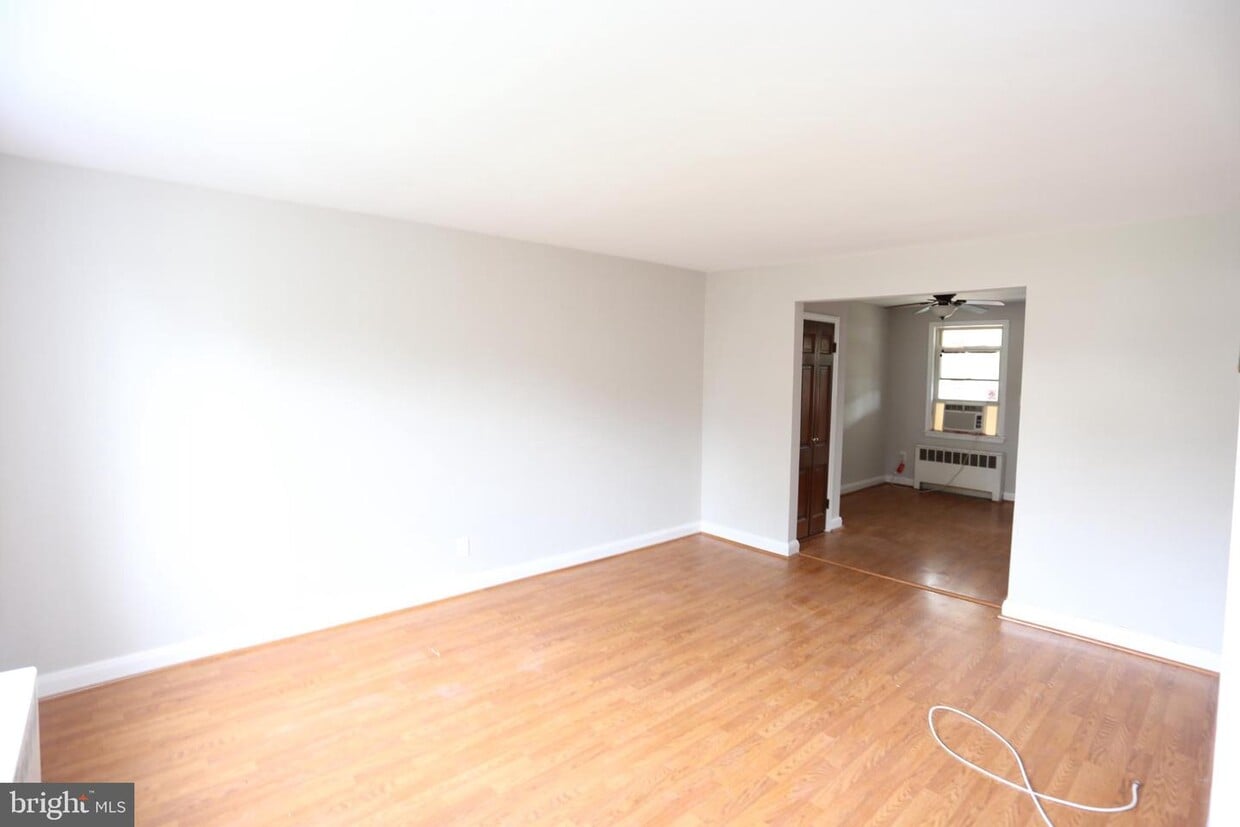
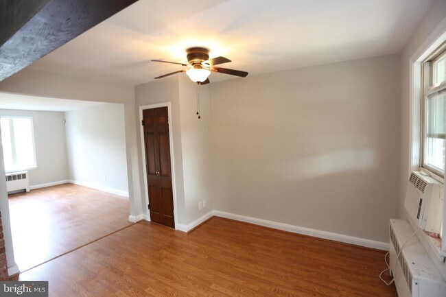
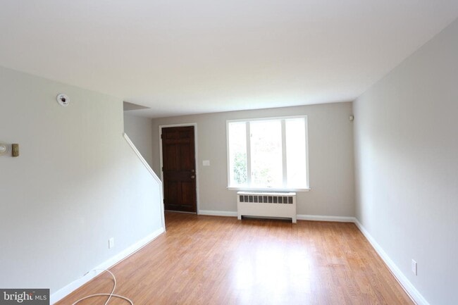
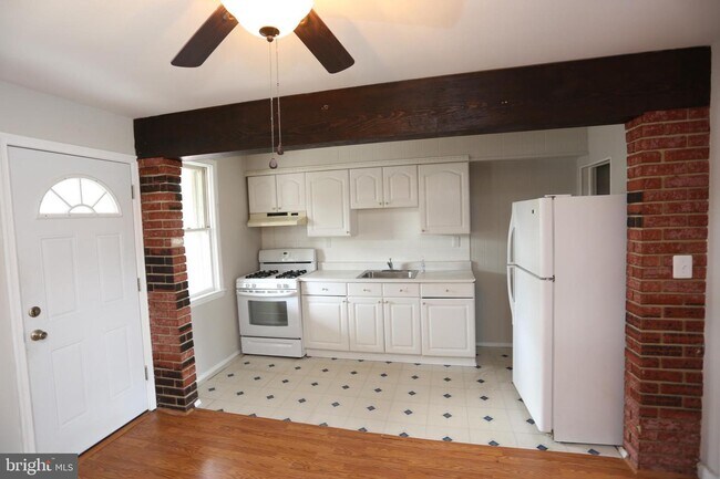
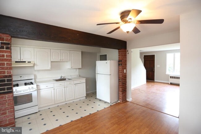
Clean 2 bedroom 1 bath home with nice rear yard area. The home offers wood floors,laminate floors, ceiling fans nice size rooms built in shelves in the living room, rear covered porch, partially finished basement with cabinets from a previous kitchen set. Great office general use room. The bathroom has a skylight keeping it nice and bright.
1257 Neighbors Ave is a townhome located in Baltimore County and the 21237 ZIP Code. This area is served by the Baltimore County Public Schools attendance zone.
Townhome Features
- Basement
1257 Neighbors Ave,
Rosedale,
MD
21237
Rosedale is an unincorporated community in Baltimore County, Maryland, sitting about ten miles northeast of Baltimore. It carries the quiet character of a suburb that grew out of its agricultural roots after World War II, with traces of that history still visible in some of the older homes scattered across its seven square miles. The area's position near Interstate 95, the Baltimore Beltway, and Route 40 makes commuting into the city or heading toward other parts of the Mid-Atlantic region straightforward and practical.
Day-to-day life in Rosedale leans residential, with a relaxed pace that contrasts with the energy of Baltimore's downtown core, which remains well within reach. The housing stock reflects that suburban character, with a mix of garden-style apartment communities, townhomes, and single-family rentals giving prospective renters real options across different needs and budgets.
Learn more about living in Rosedale
Amenities
- Basement
Education
| Colleges & Universities | Distance | ||
|---|---|---|---|
| Colleges & Universities | Distance | ||
| Drive: | 7 min | 3.0 mi | |
| Drive: | 10 min | 4.9 mi | |
| Drive: | 16 min | 6.3 mi | |
| Drive: | 15 min | 6.4 mi |
1257 Neighbors Ave is within 7 minutes or 3.0 miles from CCBC Essex. It is also near Johns Hopkins Medicine and Morgan State University.
Schools


Public Elementary School
Grades PK-5
615 Students
Attendance Zone
Public Middle School
Grades 6-8
903 Students
Attendance Zone
Public High School
Grades 9-12
1,365 Students
Attendance Zone
Private Elementary, Middle & High School
Grades PK-12
Nearby
Private Elementary & Middle School
Grades PK-8
339 Students
Nearby
School data provided by
 The GreatSchools Rating helps parents compare schools within a state based on a variety of school quality indicators and provides a helpful picture of how effectively each school serves all of its students. Ratings are on a scale of 1 (below average) to 10 (above average) and can include test scores, college readiness, academic progress, advanced courses, equity, discipline and attendance data. We also advise parents to visit schools, consider other information on school performance and programs, and consider family needs as part of the school selection process.
View GreatSchools Rating Methodology
Data provided by GreatSchools.org © 2026. All rights reserved.
View GreatSchools Rating Methodology
Data provided by GreatSchools.org © 2026. All rights reserved.
Transportation options available in Rosedale include Johns Hopkins Hospital, located 5.8 miles from 1257 Neighbors Ave. 1257 Neighbors Ave is near Baltimore/Washington International Thurgood Marshall, located 18.5 miles or 30 minutes away.
| Transit / Subway | Distance | ||
|---|---|---|---|
| Transit / Subway | Distance | ||
| Drive: | 14 min | 5.8 mi | |
| Drive: | 15 min | 6.3 mi | |
| Drive: | 16 min | 6.8 mi | |
|
|
Drive: | 18 min | 7.2 mi |
|
|
Drive: | 18 min | 7.2 mi |
| Commuter Rail | Distance | ||
|---|---|---|---|
| Commuter Rail | Distance | ||
| Drive: | 12 min | 5.8 mi | |
|
|
Drive: | 18 min | 7.3 mi |
| Drive: | 18 min | 7.5 mi | |
| Drive: | 21 min | 8.7 mi | |
| Drive: | 27 min | 15.7 mi |
| Airports | Distance | ||
|---|---|---|---|
| Airports | Distance | ||
|
Baltimore/Washington International Thurgood Marshall
|
Drive: | 30 min | 18.5 mi |
Walkability Near 1257 Neighbors Ave Rosedale, MD 21237
Getting Around
 What do Walkability, Transit, Drivability, and Bikeability mean?
Walkability measures the walking distance to day-to-day needs.
Transit measures access to public transportation.
Drivability measures congestion, parking availability, and access to major roads.
Bikeability measures the suitability for cycling.
How It Works
What do Walkability, Transit, Drivability, and Bikeability mean?
Walkability measures the walking distance to day-to-day needs.
Transit measures access to public transportation.
Drivability measures congestion, parking availability, and access to major roads.
Bikeability measures the suitability for cycling.
How It Works
Fairly Walkable
Walkability
50
/ 100
Limited Public Transit
Transit
30
/ 100
Exceptionally Drivable
Drivability
90
/ 100
Somewhat Bikeable
Bikeability
30
/ 100
Scores provided by
-
Soundscore™
-
/ 100
Traffic
-Airport
-Businesses
-Scores provided by
HowLoud What is a Sound Score Rating? A Sound Score Rating aggregates noise caused by vehicle traffic, airplane traffic and local sources. How It WorksTime and distance from 1257 Neighbors Ave.
| Shopping Centers | Distance | ||
|---|---|---|---|
| Shopping Centers | Distance | ||
| Walk: | 10 min | 0.5 mi | |
| Drive: | 5 min | 1.2 mi | |
| Drive: | 4 min | 1.4 mi |
1257 Neighbors Ave has 3 shopping centers within 1.4 miles, which is about a 4-minute drive. The miles and minutes will be for the farthest away property.
| Parks and Recreation | Distance | ||
|---|---|---|---|
| Parks and Recreation | Distance | ||
|
Maryland Natural History Society
|
Drive: | 9 min | 3.7 mi |
|
Herring Run Park
|
Drive: | 11 min | 4.9 mi |
|
Patterson Park
|
Drive: | 12 min | 5.1 mi |
|
Clifton Park
|
Drive: | 13 min | 5.6 mi |
|
Patterson Park Audubon Center
|
Drive: | 14 min | 5.6 mi |
1257 Neighbors Ave has 5 parks within 5.6 miles, including Maryland Natural History Society, Herring Run Park, and Patterson Park.
| Hospitals | Distance | ||
|---|---|---|---|
| Hospitals | Distance | ||
| Drive: | 6 min | 2.6 mi | |
| Drive: | 9 min | 4.7 mi | |
| Drive: | 13 min | 5.4 mi |
1257 Neighbors Ave has 3 hospitals within 5.4 miles, the nearest is MedStar Franklin Square Medical Center which is 2.6 miles away and a 6 minute drive.
| Military Bases | Distance | ||
|---|---|---|---|
| Military Bases | Distance | ||
| Drive: | 40 min | 24.7 mi | |
| Drive: | 61 min | 43.6 mi | |
| Drive: | 67 min | 46.1 mi |
1257 Neighbors Ave has 3 military bases within 46.1 miles, the nearest is Fort George Meade which is 24.7 miles away and a 40 minute drive.
You May Also Like
Similar Rentals Nearby


What Are Walk Score®, Transit Score®, and Bike Score® Ratings?
Walk Score® measures the walkability of any address. Transit Score® measures access to public transit. Bike Score® measures the bikeability of any address.
What is a Sound Score Rating?
A Sound Score Rating aggregates noise caused by vehicle traffic, airplane traffic and local sources.

1257 Neighbors Ave
Rosedale, MD 21237