
$2,295
/ Month
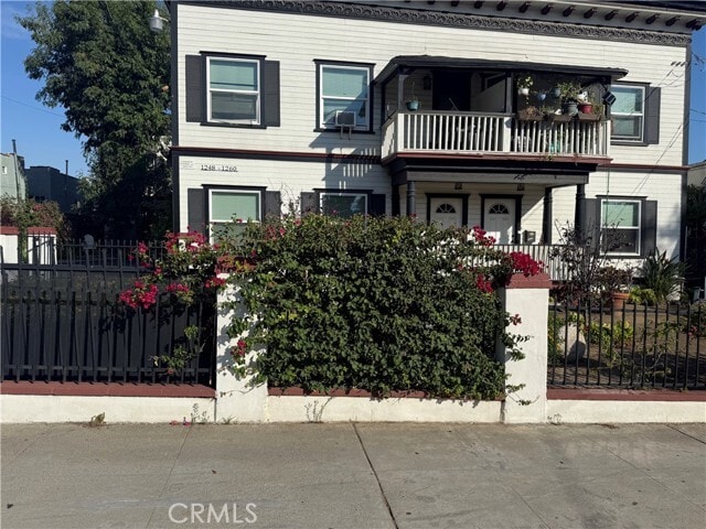
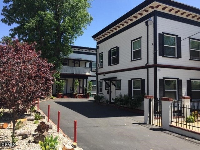
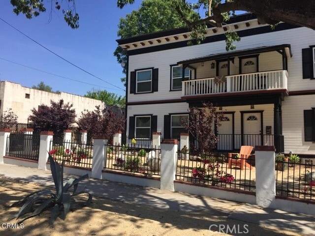
1254 N Raymond Ave
Pasadena, CA 91103
Today
Favorites
818-590-9246
-
Bedrooms
1
-
Bathrooms
1
-
Square Feet
700 sq ft
-
Available
Available Now
Highlights
- Patio
- Fenced Lot
1254 N Raymond Ave

Favorites
About This Home
12 Month Lease,
$2,295 deposit,
Available Now
Move right into this beautifully updated 1 bed, 1 bath apartment located in one of North Pasadena’s most convenient and desirable neighborhoods. This bright and airy unit features modern finishes throughout, including fresh paint, new flooring, and an upgraded kitchen with sleek countertops, plenty of cabinet space, refrigerator and stove. The spacious living area offers plenty of room to relax or work from home. The bedroom provides a peaceful retreat with generous closet space and enough room for a king size bed. The updated bathroom with a tub and shower combination completes the clean, contemporary feel. There is also incredible closet space galore for your wardrobe or essentials. This home provides the perfect blend of style and function. Community laundry and 1 parking space round out this fantastic unit! Old Town Pasadena nearby and access to the 210 and 2 freeways for an easy commute to downtown LA. ~Welcome Home~ MLS# PF25242372
1254 N Raymond Ave is an apartment community located in Los Angeles County and the 91103 ZIP Code.
* Price shown is base rent. Excludes user-selected optional fees and variable or usage-based fees and required charges due at or prior to move-in or at move-out. Price, availability, fees, and any applicable rent special are subject to change without notice.
* Square footage definitions vary. Displayed square footage is approximate.
Features
Air Conditioning
Refrigerator
Tile Floors
Heating
- Air Conditioning
- Heating
- Range
- Refrigerator
- Tile Floors
- Vinyl Flooring
- Laundry Facilities
- Fenced Lot
- Patio
Fees and Policies
The fees below are based on community-supplied data and may exclude additional fees and utilities.
- Parking
-
Surface Lot--Assigned Parking
-
Other--Assigned Parking
Details
Utilities Included
-
Water
-
Trash Removal
Lease Options
-
12 Months
Contact
- Listed by Patricia Fluhr | Berkshire Hathaway Home Serv.
- Phone Number
- Contact
-
Source
 California Regional Multiple Listing Service
Copyright 2025 © California Regional MLS. All rights reserved.
Location
Get Directions
Amenities
- Air Conditioning
- Heating
- Range
- Refrigerator
- Tile Floors
- Vinyl Flooring
- Laundry Facilities
- Fenced Lot
- Patio
Expenses
Utilities Included
Water, Trash Removal
Included
Near the San Gabriel Mountains, where I-210 meets State Route 134 and becomes the Foothill Freeway, rests Pasadena’s Garfield Heights neighborhood. Primarily a residential area, Garfield Heights contains a number of markets, churches, and temples. Garfield Heights residents enjoy access to neighboring parks such as La Pintoresca Park and City of Pasadena Robinson Park.
There are a host of amenities located within close proximity to Garfield Heights. Among the many amenities are the Rose Bowl Stadium, Kidspace Children’s Museum, Norton Simon Museum, Brookside Golf and Country Club, Pasadena Convention Center, Paseo Colorado, and the California Institute of Technology.
Served by several Metro Local lines and Pasadena Transit routes, getting around Garfield Height is a breeze.
Learn more about living in Garfield Heights
Education
| Colleges & Universities | Distance | ||
|---|---|---|---|
| Colleges & Universities | Distance | ||
| Drive: | 4 min | 1.9 mi | |
| Drive: | 10 min | 3.1 mi | |
| Drive: | 7 min | 3.4 mi | |
| Drive: | 9 min | 3.6 mi |
1254 N Raymond Ave is within 4 minutes or 1.9 miles from Fuller Theological Seminary. It is also near Art Center College of Design and Pasadena City College.
Transportation options available in Pasadena include Memorial Park Station, located 1.6 miles from 1254 N Raymond Ave. 1254 N Raymond Ave is near Bob Hope, located 17.4 miles or 24 minutes away, and Los Angeles International, located 25.9 miles or 42 minutes away.
| Transit / Subway | Distance | ||
|---|---|---|---|
| Transit / Subway | Distance | ||
|
|
Drive: | 4 min | 1.6 mi |
|
|
Drive: | 5 min | 2.0 mi |
|
|
Drive: | 4 min | 2.1 mi |
|
|
Drive: | 6 min | 2.6 mi |
|
|
Drive: | 6 min | 3.1 mi |
| Commuter Rail | Distance | ||
|---|---|---|---|
| Commuter Rail | Distance | ||
|
|
Drive: | 14 min | 9.9 mi |
|
|
Drive: | 19 min | 10.8 mi |
|
|
Drive: | 21 min | 10.9 mi |
|
|
Drive: | 22 min | 12.1 mi |
| Drive: | 23 min | 15.0 mi |
| Airports | Distance | ||
|---|---|---|---|
| Airports | Distance | ||
|
Bob Hope
|
Drive: | 24 min | 17.4 mi |
|
Los Angeles International
|
Drive: | 42 min | 25.9 mi |
Time and distance from 1254 N Raymond Ave.
| Shopping Centers | Distance | ||
|---|---|---|---|
| Shopping Centers | Distance | ||
| Walk: | 4 min | 0.2 mi | |
| Walk: | 20 min | 1.0 mi | |
| Walk: | 21 min | 1.1 mi |
1254 N Raymond Ave has 3 shopping centers within 1.1 miles, which is about a 21-minute walk. The miles and minutes will be for the farthest away property.
| Parks and Recreation | Distance | ||
|---|---|---|---|
| Parks and Recreation | Distance | ||
|
Kidspace Children's Museum
|
Drive: | 5 min | 1.9 mi |
|
Jet Propulsion Laboratory
|
Drive: | 4 min | 2.2 mi |
|
Eaton Canyon Nature Center
|
Drive: | 8 min | 3.8 mi |
|
Huntington Botanical Gardens
|
Drive: | 11 min | 4.7 mi |
|
Descanso Gardens
|
Drive: | 10 min | 5.7 mi |
1254 N Raymond Ave has 5 parks within 5.7 miles, including Kidspace Children's Museum, Jet Propulsion Laboratory, and Eaton Canyon Nature Center.
| Hospitals | Distance | ||
|---|---|---|---|
| Hospitals | Distance | ||
| Drive: | 5 min | 2.4 mi | |
| Drive: | 9 min | 5.1 mi | |
| Drive: | 9 min | 5.6 mi |
1254 N Raymond Ave has 3 hospitals within 5.6 miles, the nearest is Huntington Memorial Hospital which is 2.4 miles away and a 5 minute drive.
| Military Bases | Distance | ||
|---|---|---|---|
| Military Bases | Distance | ||
| Drive: | 39 min | 27.5 mi | |
| Drive: | 49 min | 31.0 mi |
1254 N Raymond Ave is 27.5 miles from Los Angeles Air Force Base, and is convenient to other military bases, including Los Alamitos Army Airfield.
You May Also Like
Similar Rentals Nearby


 - Violet on Virgil")

 - AVA Burbank")


What Are Walk Score®, Transit Score®, and Bike Score® Ratings?
Walk Score® measures the walkability of any address. Transit Score® measures access to public transit. Bike Score® measures the bikeability of any address.
What is a Sound Score Rating?
A Sound Score Rating aggregates noise caused by vehicle traffic, airplane traffic and local sources
1254 N Raymond Ave
Pasadena, CA 91103