
$1,995
/ Month
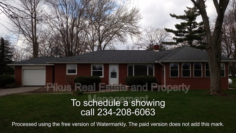
12533 McCallum Ave NE
Alliance, OH 44601
Favorites
330-616-3597
-
Bedrooms
3
-
Bathrooms
2
-
Square Feet
1,825 sq ft
-
Available
Available Now
12533 McCallum Ave NE

Favorites
About This Home
$1,995 deposit,
Available Now
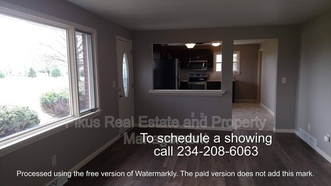
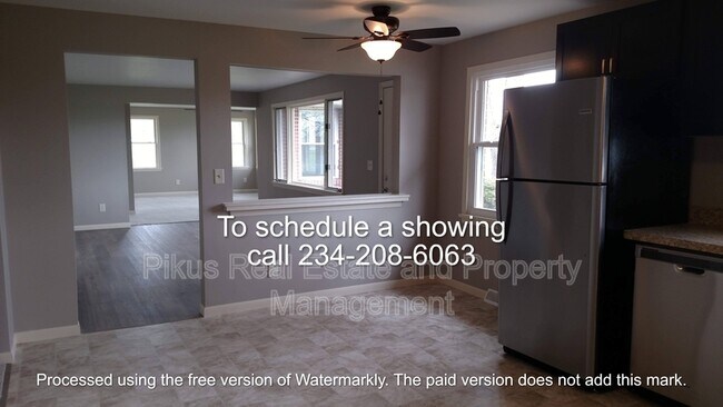
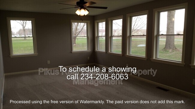
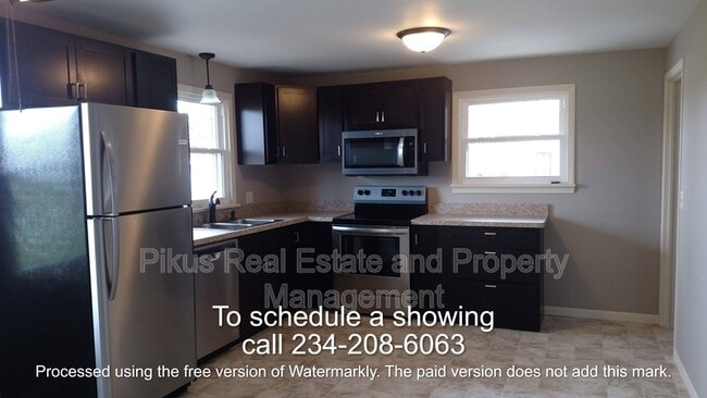
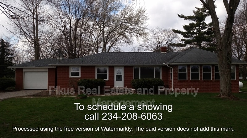
Welcome to 12533 McCallum, a beautiful brick ranch in Marlington LSD. Home offers very large main suite with his and her closets, windowed living room, large dining room, eat in kitchen, 1st floor laundry, full basement, 1 car garage, small hobby barn, all on 1.5 acres. Home has been renovated and includes kitchen with stainless steel appliances, 2 full bathrooms, new carpet flooring throughout, fresh paint, and much more. Call today to schedule a showing! 24-month lease - Well and Septic- Tenants pay Propane, Electric, Trash
12533 Mccallum Ave Ne is a house located in Stark County and the 44601 ZIP Code. This area is served by the Marlington Local School District attendance zone.
* Price shown is base rent. Excludes user-selected optional fees and variable or usage-based fees and required charges due at or prior to move-in or at move-out. Price, availability, fees, and any applicable rent special are subject to change without notice.
* Square footage definitions vary. Displayed square footage is approximate.
Fees and Policies
The fees listed below are community-provided and may exclude utilities or add-ons. All payments are made directly to the property and are non-refundable unless otherwise specified. Use the Cost Calculator to determine costs based on your needs.
-
One-Time Basics
-
Due at Move-In
-
Security Deposit - RefundableCharged per unit.$1,995
-
-
Due at Move-In
-
Dogs
-
Allowed
-
Property Fee Disclaimer: Based on community-supplied data and independent market research. Subject to change without notice. May exclude fees for mandatory or optional services and usage-based utilities.
House Features
- Dishwasher
- Refrigerator
Contact
- Phone Number
- Contact
Location
Get Directions
Alliance sits about 20 miles northeast of Canton in Stark County, shaped by its origins as a railroad and manufacturing hub. Founded in 1854 through the merger of three smaller communities, the city carries that layered history through its pre-war architecture, a walkable downtown, and the University of Mount Union, a private liberal arts college established in 1846 that anchors much of the city's day-to-day energy. Alliance is also Ohio's Carnation City, recognized for its ties to the scarlet carnation, the state flower, which the city celebrates each year with the Greater Alliance Carnation Festival. The downtown core along East State Street offers a compact mix of local dining and retail, while the historic district draws those with an interest in architecture and local heritage. Glamorgan Castle adds a distinct landmark presence to the landscape.
Learn more about living in Alliance
Amenities
- Dishwasher
- Refrigerator
Education
| Colleges & Universities | Distance | ||
|---|---|---|---|
| Colleges & Universities | Distance | ||
| Drive: | 12 min | 6.4 mi | |
| Drive: | 26 min | 16.7 mi | |
| Drive: | 30 min | 16.8 mi | |
| Drive: | 34 min | 20.7 mi |
12533 McCallum Ave NE is within 12 minutes or 6.4 miles from Mount Union College. It is also near Walsh University and Malone University.
Schools


Public Elementary School
Grades K-5
303 Students
Attendance Zone
Public Elementary School
Grades K-5
276 Students
Attendance Zone
Public Elementary School
Grades PK-5
408 Students
Nearby
Public Middle School
Grades 6-8
413 Students
Attendance Zone
Public High School
Grades 9-12
576 Students
Attendance Zone
Private Elementary & Middle School
Grades K-8
21 Students
Nearby
Private Elementary School
Grades PK-5
119 Students
Nearby
Private Middle & High School
Grades 6-12
379 Students
Nearby
School data provided by
 The GreatSchools Rating helps parents compare schools within a state based on a variety of school quality indicators and provides a helpful picture of how effectively each school serves all of its students. Ratings are on a scale of 1 (below average) to 10 (above average) and can include test scores, college readiness, academic progress, advanced courses, equity, discipline and attendance data. We also advise parents to visit schools, consider other information on school performance and programs, and consider family needs as part of the school selection process.
View GreatSchools Rating Methodology
Data provided by GreatSchools.org © 2026. All rights reserved.
View GreatSchools Rating Methodology
Data provided by GreatSchools.org © 2026. All rights reserved.
Getting Around
 What do Walkability, Transit, Drivability, and Bikeability mean?
Walkability measures the walking distance to day-to-day needs.
Transit measures access to public transportation.
Drivability measures congestion, parking availability, and access to major roads.
Bikeability measures the suitability for cycling.
How It Works
What do Walkability, Transit, Drivability, and Bikeability mean?
Walkability measures the walking distance to day-to-day needs.
Transit measures access to public transportation.
Drivability measures congestion, parking availability, and access to major roads.
Bikeability measures the suitability for cycling.
How It Works
Not Walkable
Walkability
10
/ 100
Minimal Public Transit
Transit
0
/ 100
Exceptionally Drivable
Drivability
100
/ 100
Fairly Bikeable
Bikeability
40
/ 100
Scores provided by
-
Soundscore™
-
/ 100
Traffic
-Airport
-Businesses
-Scores provided by
HowLoud What is a Sound Score Rating? A Sound Score Rating aggregates noise caused by vehicle traffic, airplane traffic and local sources. How It WorksYou May Also Like
Similar Rentals Nearby


What Are Walk Score®, Transit Score®, and Bike Score® Ratings?
Walk Score® measures the walkability of any address. Transit Score® measures access to public transit. Bike Score® measures the bikeability of any address.
What is a Sound Score Rating?
A Sound Score Rating aggregates noise caused by vehicle traffic, airplane traffic and local sources.
12533 McCallum Ave NE
Alliance, OH 44601