
$2,850
/ Month
12500 Sturdee Dr
Upper Marlboro, MD 20772
1 Day Ago
|
Edit
Favorites
301-807-7797
-
Bedrooms
3
-
Bathrooms
2
-
Square Feet
--
-
Available
Available Now
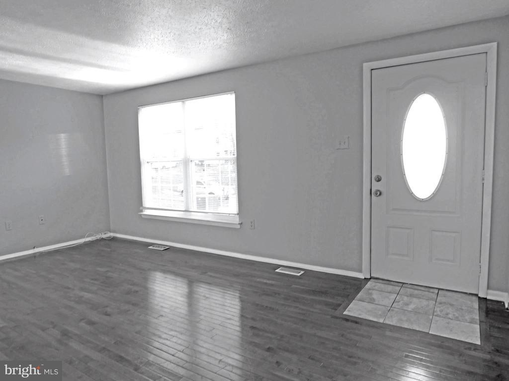
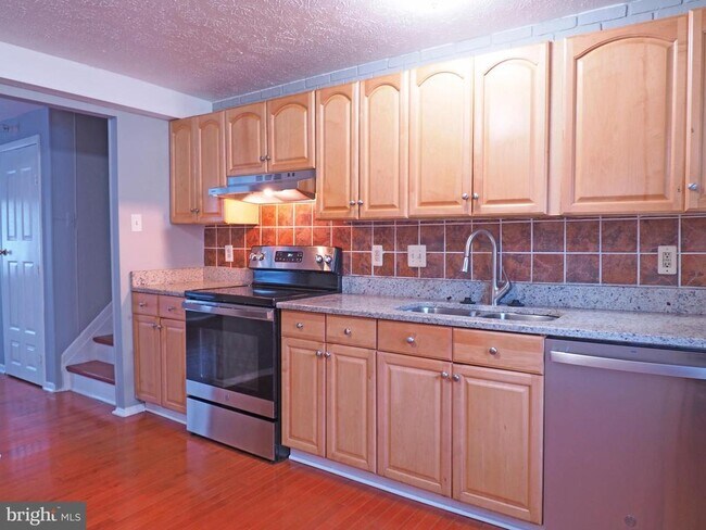
Highlights
- Wood Flooring
- Upgraded Countertops
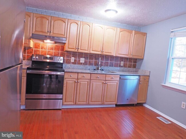
- Stainless Steel Appliances
- Eat-In Kitchen
- Living Room
- Sliding Doors
12500 Sturdee Dr

Favorites
About This Home
Available Now
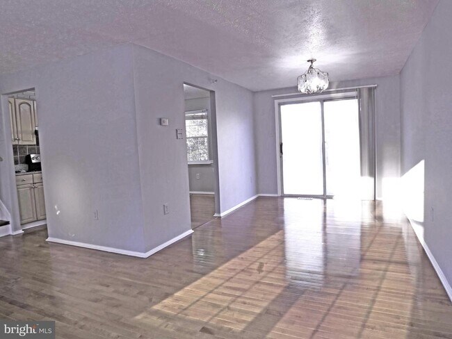
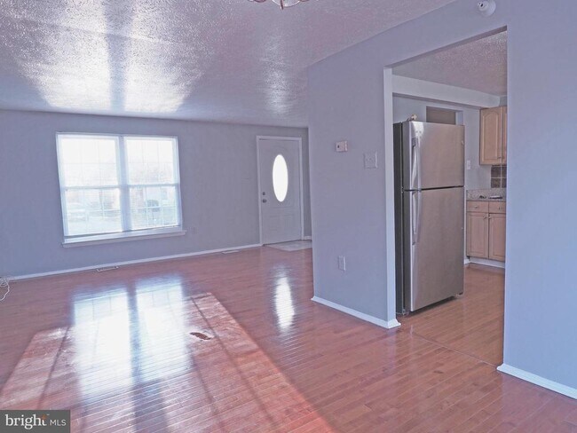
Enjoy the space you deserve in this updated detached 3 level split home on a generous corner lot in the established Queensland community of Upper Marlboro. This 3-bedroom, 2 bath home offers a comfortable main-level living room and dining room, a table-space kitchen, and a large lower-level family room with walkout access to privacy fenced yard. Off-street parking for 2 cars, a storage shed, public water/sewer, and electric heating and cooling via heat pump for everyday convenience. With approximately 1,560 finished square feet above grade and a fully finished lower level, there is plenty of room to relax, work, and entertain. Conveniently located near major routes, shopping, and employment centers, this home is a great opportunity for those seeking a single-family lifestyle in Upper Marlboro. This property has a lead free certificate.
12500 Sturdee Dr is a house located in Prince George's County and the 20772 ZIP Code. This area is served by the Prince George's County Public Schools attendance zone.
* Price shown is base rent. Excludes user-selected optional fees and variable or usage-based fees and required charges due at or prior to move-in or at move-out. Price, availability, fees, and any applicable rent special are subject to change without notice.
* Square footage definitions vary. Displayed square footage is approximate.
Home Details
Home Type
Single Family Detached Home
Year Built
Built in 1977
Bedrooms and Bathrooms
2 Full Bathrooms
3 Bedrooms
Finished Basement
Heated Basement
Walk-Out Basement
Basement Windows
Laundry in Basement
Connecting Stairway
Interior and Exterior Basement Entry
Sump Pump
Home Design
Split Level Home
Block Foundation
Frame Construction
Interior Spaces
Wood Flooring
Living Room
Sliding Doors
Dining Room
Ceiling Fan
Utility Room
Family Room
Window Screens
1,560 Sq Ft Home
Property has 3 Levels
Vinyl Clad Windows
Double Hung Windows
Kitchen
Upgraded Countertops
Stainless Steel Appliances
Eat-In Kitchen
Electric Oven or Range
Stove
Dishwasher
Range Hood
Disposal
Laundry
Electric Dryer
Washer
Listing and Financial Details
Security Deposit $2,950
12-Month Lease Term
Available 12/6/25
Assessor Parcel Number 17151730860
Tenant pays for cable TV, electricity, frozen waterpipe damage, gutter cleaning, heat, hot water, insurance, internet, light bulbs/filters/fuses/alarm care, minor interior maintenance, snow removal, water
The owner pays for trash collection
Rent includes additional storage space, air conditioning, parking
No Smoking Allowed
Coming Soon on 12/6/25
Residential Lease
Lot Details
0.26 Acre Lot
Property is zoned RR
Sprinkler System
Parking
On-Street Parking
2 Off-Street Spaces
4 Parking Spaces
2 Driveway Spaces
Utilities
Central Air
Heat Pump System
Pellet Stove burns compressed wood to generate heat
Electric Water Heater
Cable TV Available
Community Details
Overview
No Home Owners Association
Queensland Subdivision
Pet Policy
Pets allowed on a case-by-case basis
$40 Monthly Pet Rent
Contact
- Listed by Gene J Sementilli | Century 21 New Millennium
- Phone Number
- Contact
-
Source
 Bright MLS, Inc.
Copyright © 2026 Bright MLS, Inc.
Location
Get Directions
Amenities
- Dishwasher
- Basement
Popularly known as a government district in Prince George’s County in the state of Maryland, Upper Marlboro offers residents a small-town vibe. Lined with an assortment of businesses, Main Street provides immediate access to the courthouse and county administrative building.
You'll find a combination of busy thoroughfares within the city and a quiet atmosphere in the residential suburbs. To the west of downtown are residential homes on quiet streets with mostly single-family homes, parks, and civic centers. Take a short walk from Main Street to access the Prince George’s County Public system. Aside from the few grocery stores and big-box retailers, the rural nature of the area is the biggest draw for residents. But it also means you might have to head to surrounding areas for more shopping and restaurant options.
Learn more about living in Greater Upper Marlboro
Education
| Colleges & Universities | Distance | ||
|---|---|---|---|
| Colleges & Universities | Distance | ||
| Drive: | 20 min | 12.1 mi | |
| Drive: | 22 min | 14.4 mi | |
| Drive: | 23 min | 14.6 mi | |
| Drive: | 33 min | 18.8 mi |
12500 Sturdee Dr is within 20 minutes or 12.1 miles from Prince George's Comm. Coll.. It is also near Univ. of Md. Univ. Coll. and Coll. of Southern Md., Waldorf.
Schools


Public Elementary School
Grades PK-5
309 Students
Attendance Zone
Public Middle School
Grades 6-8
873 Students
Attendance Zone
Public High School
Grades 9-12
2,257 Students
Attendance Zone
Private Elementary, Middle & High School
Grades PK-12
183 Students
Nearby
School data provided by
 The GreatSchools Rating helps parents compare schools within a state based on a variety of school quality indicators and provides a helpful picture of how effectively each school serves all of its students. Ratings are on a scale of 1 (below average) to 10 (above average) and can include test scores, college readiness, academic progress, advanced courses, equity, discipline and attendance data. We also advise parents to visit schools, consider other information on school performance and programs, and consider family needs as part of the school selection process.
View GreatSchools Rating Methodology
Data provided by GreatSchools.org © 2026. All rights reserved.
View GreatSchools Rating Methodology
Data provided by GreatSchools.org © 2026. All rights reserved.
Transportation options available in Upper Marlboro include Morgan Boulevard, located 11.6 miles from 12500 Sturdee Dr. 12500 Sturdee Dr is near Ronald Reagan Washington Ntl, located 22.4 miles or 39 minutes away, and Baltimore/Washington International Thurgood Marshall, located 35.0 miles or 52 minutes away.
| Transit / Subway | Distance | ||
|---|---|---|---|
| Transit / Subway | Distance | ||
|
|
Drive: | 23 min | 11.6 mi |
|
|
Drive: | 23 min | 12.1 mi |
|
|
Drive: | 24 min | 13.1 mi |
|
|
Drive: | 23 min | 13.6 mi |
|
|
Drive: | 24 min | 13.7 mi |
| Commuter Rail | Distance | ||
|---|---|---|---|
| Commuter Rail | Distance | ||
| Drive: | 29 min | 16.4 mi | |
|
|
Drive: | 29 min | 16.4 mi |
|
|
Drive: | 30 min | 16.7 mi |
|
|
Drive: | 32 min | 19.0 mi |
|
|
Drive: | 33 min | 19.2 mi |
| Airports | Distance | ||
|---|---|---|---|
| Airports | Distance | ||
|
Ronald Reagan Washington Ntl
|
Drive: | 39 min | 22.4 mi |
|
Baltimore/Washington International Thurgood Marshall
|
Drive: | 52 min | 35.0 mi |
Time and distance from 12500 Sturdee Dr.
| Shopping Centers | Distance | ||
|---|---|---|---|
| Shopping Centers | Distance | ||
| Walk: | 37 min | 2.0 mi | |
| Drive: | 5 min | 2.7 mi | |
| Drive: | 6 min | 3.6 mi |
12500 Sturdee Dr has 3 shopping centers within 3.6 miles, which is about a 6-minute drive. The miles and minutes will be for the farthest away property.
| Parks and Recreation | Distance | ||
|---|---|---|---|
| Parks and Recreation | Distance | ||
|
School House Pond
|
Drive: | 8 min | 3.4 mi |
|
Rosaryville State Park
|
Drive: | 7 min | 4.0 mi |
|
Cheltenham Wetlands Park
|
Drive: | 7 min | 4.3 mi |
|
Jug Bay Natural Area
|
Drive: | 15 min | 5.8 mi |
|
Mount Calvert Historical and Archaeological Park
|
Drive: | 16 min | 5.8 mi |
12500 Sturdee Dr has 5 parks within 5.8 miles, including School House Pond, Rosaryville State Park, and Cheltenham Wetlands Park.
| Hospitals | Distance | ||
|---|---|---|---|
| Hospitals | Distance | ||
| Drive: | 15 min | 8.0 mi |
12500 Sturdee Dr is 8.0 miles and a 15 minute drive from MedStar Southern Maryland Hospital Center.
| Military Bases | Distance | ||
|---|---|---|---|
| Military Bases | Distance | ||
| Drive: | 20 min | 10.3 mi | |
| Drive: | 30 min | 17.2 mi |
12500 Sturdee Dr is 10.3 miles from Andrews Airforce Base, and is convenient to other military bases, including Washington Navy Yard.
You May Also Like
Similar Rentals Nearby


What Are Walk Score®, Transit Score®, and Bike Score® Ratings?
Walk Score® measures the walkability of any address. Transit Score® measures access to public transit. Bike Score® measures the bikeability of any address.
What is a Sound Score Rating?
A Sound Score Rating aggregates noise caused by vehicle traffic, airplane traffic and local sources

12500 Sturdee Dr
Upper Marlboro, MD 20772