
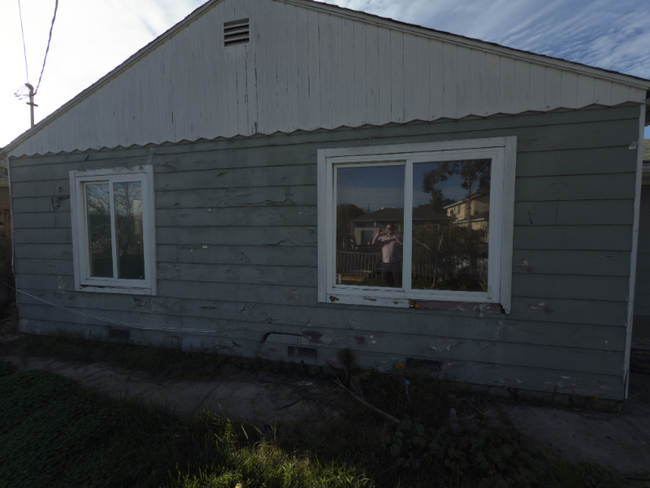
1245 Laurel Ave
East Palo Alto, CA 94303
-
Bedrooms
3
-
Bathrooms
1
-
Square Feet
960 sq ft
-
Available
Available Now
Highlights
- Pets Allowed
- Hardwood Floors
- Fenced Lot

About This Home
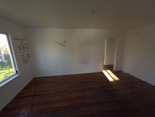
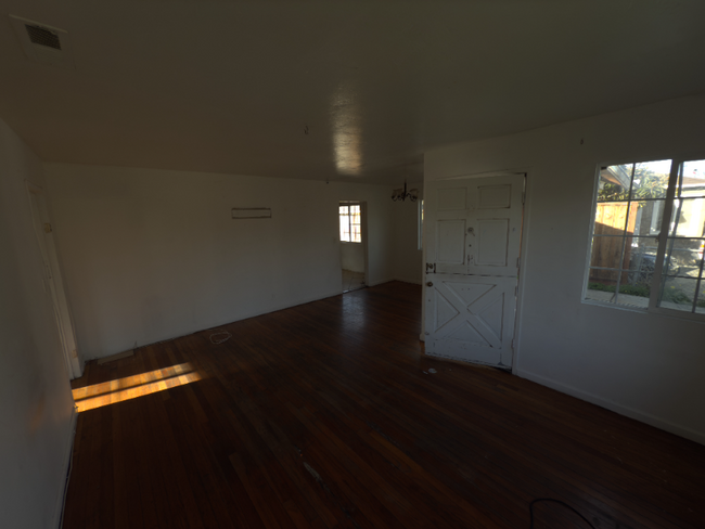
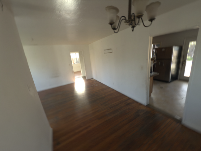
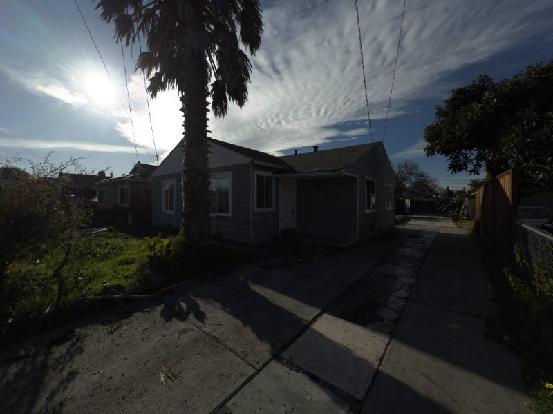
Property Id: 1850932 This 3-bedroom, 1-bath single-family home offers 960 sqft of living space on a generously sized lot. It's not perfect—but that's why the rent is priced lower than most in the area. The home is older and needs some cosmetic work and minor repairs, but it offers solid bones, functionality, and a fenced yard. If you value space, affordability, and don't mind putting up with a few imperfections, this could be a great match. Features: • 3 Bedrooms / 1 Full Bath • Spacious, fenced yard • Off-street parking • Convenient to University Ave, Hwy 101, Facebook & Amazon campuses • Pet-friendly with deposit This home is being rented as-is and is ideal for tenants seeking a no-frills, simple living space in a central location—and who are comfortable with basic upkeep and maintenance. Details: • Available: Immediately • Rent: $4,000/month • Security Deposit: One month's rent • Pets: Allowed with additional deposit • Smoking: Not allowed
1245 Laurel Ave is a house located in San Mateo County and the 94303 ZIP Code. This area is served by the Ravenswood City Elementary attendance zone.
House Features
- Washer/Dryer
- Dishwasher
- Hardwood Floors
- Fenced Lot
Fees and Policies
The fees below are based on community-supplied data and may exclude additional fees and utilities.
- Dogs Allowed
-
Fees not specified
- Cats Allowed
-
Fees not specified
Details
Utilities Included
-
Water
Contact
- Phone Number
- Contact
-
Source

- Washer/Dryer
- Dishwasher
- Hardwood Floors
- Fenced Lot
Situated on the coast of the San Francisco Bay on the San Francisco Peninsula, East Palo Alto is a bustling city on the rise with the influx of tech companies. Friendly neighbors and distant mountain views define this small coastal town.
With its central location between San Francisco and San Jose, entertainment options are endless. Explore the delicious cuisine and fantastic bars in San Jose, or visit the plentiful museums and waterfront green space in San Francisco. Stanford University is a quick commute for East Palo Alto residents, located just five miles southwest of town, so be sure to check out its beautiful campus in nearby Stanford.
East Palo Alto offers an accessible rocky shoreline overlooking the glistening San Francisco Bay, as well as sports fields, open green space, and playgrounds in its well-kept community parks.
Learn more about living in East Palo Alto| Colleges & Universities | Distance | ||
|---|---|---|---|
| Colleges & Universities | Distance | ||
| Drive: | 10 min | 4.7 mi | |
| Drive: | 14 min | 4.8 mi | |
| Drive: | 10 min | 6.0 mi | |
| Drive: | 18 min | 8.8 mi |


View GreatSchools Rating Methodology
Transportation options available in East Palo Alto include Bayshore/Nasa Station, located 8.5 miles from 1245 Laurel Ave. 1245 Laurel Ave is near Norman Y Mineta San Jose International, located 15.9 miles or 21 minutes away, and San Francisco International, located 18.4 miles or 24 minutes away.
| Transit / Subway | Distance | ||
|---|---|---|---|
| Transit / Subway | Distance | ||
|
|
Drive: | 12 min | 8.5 mi |
|
|
Drive: | 12 min | 8.8 mi |
|
|
Drive: | 13 min | 8.9 mi |
|
|
Drive: | 13 min | 9.0 mi |
|
|
Drive: | 13 min | 9.3 mi |
| Commuter Rail | Distance | ||
|---|---|---|---|
| Commuter Rail | Distance | ||
| Drive: | 8 min | 2.8 mi | |
| Drive: | 8 min | 3.1 mi | |
| Drive: | 9 min | 4.9 mi | |
| Drive: | 9 min | 5.5 mi | |
| Drive: | 11 min | 6.8 mi |
| Airports | Distance | ||
|---|---|---|---|
| Airports | Distance | ||
|
Norman Y Mineta San Jose International
|
Drive: | 21 min | 15.9 mi |
|
San Francisco International
|
Drive: | 24 min | 18.4 mi |
Time and distance from 1245 Laurel Ave.
| Shopping Centers | Distance | ||
|---|---|---|---|
| Shopping Centers | Distance | ||
| Walk: | 15 min | 0.8 mi | |
| Drive: | 5 min | 1.8 mi | |
| Drive: | 5 min | 2.8 mi |
| Parks and Recreation | Distance | ||
|---|---|---|---|
| Parks and Recreation | Distance | ||
|
Seminary Oaks Park
|
Drive: | 4 min | 1.5 mi |
|
Ravenswood Open Space Preserve
|
Drive: | 3 min | 1.7 mi |
|
Hopkins Creekside Park
|
Drive: | 5 min | 1.7 mi |
|
Burgess Park
|
Drive: | 7 min | 2.6 mi |
|
Bayfront Park
|
Drive: | 7 min | 2.8 mi |
| Hospitals | Distance | ||
|---|---|---|---|
| Hospitals | Distance | ||
| Drive: | 11 min | 3.9 mi | |
| Drive: | 13 min | 4.5 mi | |
| Drive: | 7 min | 4.8 mi |
| Military Bases | Distance | ||
|---|---|---|---|
| Military Bases | Distance | ||
| Drive: | 14 min | 8.8 mi |
You May Also Like
What Are Walk Score®, Transit Score®, and Bike Score® Ratings?
Walk Score® measures the walkability of any address. Transit Score® measures access to public transit. Bike Score® measures the bikeability of any address.
What is a Sound Score Rating?
A Sound Score Rating aggregates noise caused by vehicle traffic, airplane traffic and local sources
1245 Laurel Ave
East Palo Alto, CA 94303