

$4,000 / Month
1240 Baywood Ave
South San Francisco, CA 94080
2 Weeks Ago
Favorites
1240 Baywood Ave

Favorites
Check Back Soon for Upcoming Availability
| Beds | Baths | Average SF |
|---|---|---|
| 3 Bedrooms 3 Bedrooms 3 Br | 1 Bath 1 Bath 1 Ba | 1,100 SF |
About This Property
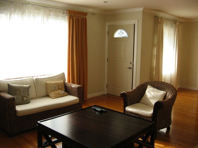
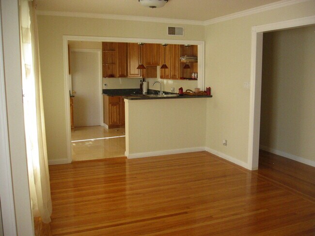
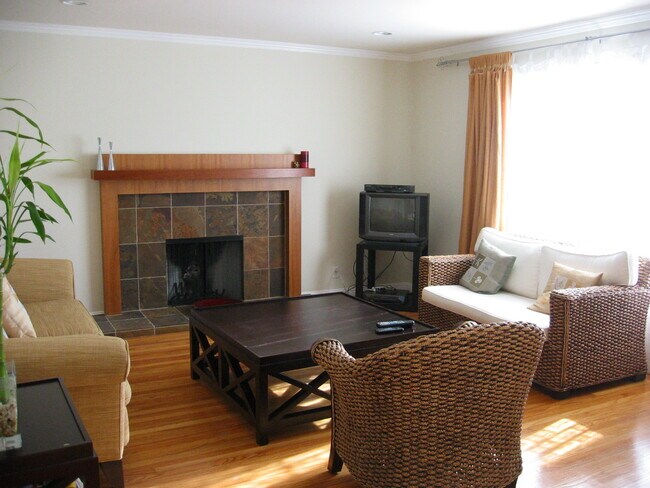
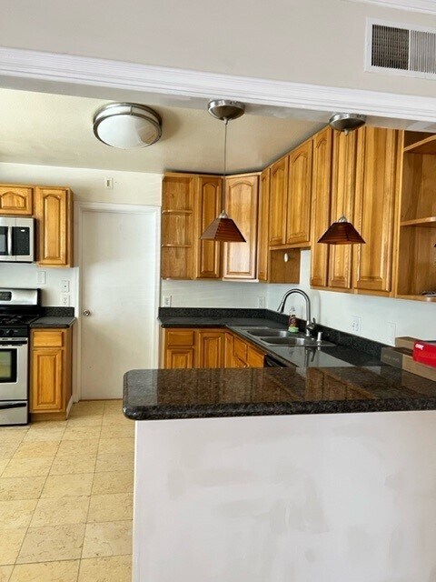
3 Bed, 1 Bath Attached 1 car garage Approx. 1,100 sq ft of living space Corner Lot House – plenty of parking Sunshine Garden neighborhood of South San Francisco HOME FEATURES: Remodeled Kitchen Granite countertops Stainless steel appliances Marble floor Oak cabinets New exterior paint Sanded and refinished hardwood Other highlights Spacious living room with great sunlight throughout the house Original hardwood floors throughout Crown molding throughout Custom fireplace enclosure and mantle Canned lights in the living room Central heat Washer & Dryer Community Sunshine Garden neighborhood of South San Francisco Within walking distance to: SSF Bart Station, El Camino High School, Sunshine Garden Elementary School, Starbucks, Trader Joes, Costco and other shops.
1240 Baywood Ave is a house located in San Mateo County and the 94080 ZIP Code. This area is served by the South San Francisco Unified attendance zone.
House Features
- Washer/Dryer
- Washer/Dryer Hookup
- Dishwasher
Location
Get Directions
Folks in South San Francisco have easy access to The City via I-280, the 101, or BART rail service. This fact, coupled with the much lower crime rate and the area’s many excellent schools, makes South San Francisco apartments an appealing option for commuters, particularly those raising families.
Although primarily a residential community, South San Francisco does have a fairly active downtown scene, with much of the dining and entertainment centered around the intersection of Grande Avenue and Linden Avenue and shopping centers on the south side of town.
Many parks and nature preserves are scattered around the area, including the huge Sweeney Ridge and Fairway Park just to the west of the city limits. San Francisco International Airport sits directly south of town, making it highly convenient to travel anywhere.
Learn more about living in South San FranciscoBelow are rent ranges for similar nearby apartments
Amenities
- Washer/Dryer
- Washer/Dryer Hookup
- Dishwasher
Education
| Colleges & Universities | Distance | ||
|---|---|---|---|
| Colleges & Universities | Distance | ||
| Drive: | 10 min | 4.6 mi | |
| Drive: | 12 min | 6.3 mi | |
| Drive: | 12 min | 6.7 mi | |
| Drive: | 18 min | 8.9 mi |
1240 Baywood Ave is within 10 minutes or 4.6 miles from Skyline College. It is also near City College of San Francisco and San Francisco State University.
Schools


Public Elementary School
Grades K-5
Nearby
Public Elementary School
Grades K-5
334 Students
Attendance Zone
Public Middle School
Grades 6-8
612 Students
Attendance Zone
Public High School
Grades 9-12
1,173 Students
Attendance Zone
Private Elementary, Middle & High School
Grades 1-12
17 Students
Nearby
Private Elementary & Middle School
Grades PK-8
129 Students
Nearby
Private Elementary & Middle School
Grades K-8
Nearby
School data provided by
 The GreatSchools Rating helps parents compare schools within a state based on a variety of school quality indicators and provides a helpful picture of how effectively each school serves all of its students. Ratings are on a scale of 1 (below average) to 10 (above average) and can include test scores, college readiness, academic progress, advanced courses, equity, discipline and attendance data. We also advise parents to visit schools, consider other information on school performance and programs, and consider family needs as part of the school selection process.
View GreatSchools Rating Methodology
Data provided by GreatSchools.org © 2025. All rights reserved.
View GreatSchools Rating Methodology
Data provided by GreatSchools.org © 2025. All rights reserved.
Transportation options available in South San Francisco include South San Francisco Station, located 0.3 mile from 1240 Baywood Ave. 1240 Baywood Ave is near San Francisco International, located 5.8 miles or 13 minutes away, and Metro Oakland International, located 31.3 miles or 45 minutes away.
| Transit / Subway | Distance | ||
|---|---|---|---|
| Transit / Subway | Distance | ||
|
|
Walk: | 5 min | 0.3 mi |
|
|
Walk: | 6 min | 0.3 mi |
|
|
Drive: | 5 min | 2.5 mi |
|
|
Drive: | 7 min | 2.8 mi |
| Drive: | 9 min | 4.3 mi |
| Commuter Rail | Distance | ||
|---|---|---|---|
| Commuter Rail | Distance | ||
| Drive: | 6 min | 2.8 mi | |
| Drive: | 6 min | 3.3 mi | |
| Drive: | 12 min | 7.0 mi | |
| Drive: | 13 min | 7.3 mi | |
| Drive: | 13 min | 8.0 mi |
| Airports | Distance | ||
|---|---|---|---|
| Airports | Distance | ||
|
San Francisco International
|
Drive: | 13 min | 5.8 mi |
|
Metro Oakland International
|
Drive: | 45 min | 31.3 mi |
Time and distance from 1240 Baywood Ave.
| Shopping Centers | Distance | ||
|---|---|---|---|
| Shopping Centers | Distance | ||
| Walk: | 17 min | 0.9 mi | |
| Drive: | 3 min | 1.1 mi | |
| Drive: | 3 min | 1.1 mi |
1240 Baywood Ave has 3 shopping centers within 1.1 miles, which is about a 3-minute walk. The miles and minutes will be for the farthest away property.
| Parks and Recreation | Distance | ||
|---|---|---|---|
| Parks and Recreation | Distance | ||
|
San Bruno Mountain State Park
|
Drive: | 16 min | 6.7 mi |
|
San Francisco State Univ. Observatory
|
Drive: | 13 min | 7.0 mi |
|
Charles F. Hagar Planetarium
|
Drive: | 13 min | 7.0 mi |
|
Candlestick Point State Recreation Area
|
Drive: | 17 min | 8.2 mi |
|
Pacifica State Beach
|
Drive: | 14 min | 8.7 mi |
1240 Baywood Ave has 5 parks within 8.7 miles, including San Bruno Mountain State Park, San Francisco State Univ. Observatory, and Charles F. Hagar Planetarium.
| Hospitals | Distance | ||
|---|---|---|---|
| Hospitals | Distance | ||
| Walk: | 14 min | 0.8 mi | |
| Drive: | 6 min | 2.8 mi | |
| Drive: | 11 min | 6.0 mi |
1240 Baywood Ave has 3 hospitals within 6.0 miles, the nearest is Kaiser Foundation Hospital - South San Francisco which is 0.8 mile away and a 14 minute walk.
| Military Bases | Distance | ||
|---|---|---|---|
| Military Bases | Distance | ||
| Drive: | 25 min | 10.9 mi | |
| Drive: | 25 min | 11.5 mi |
1240 Baywood Ave is 10.9 miles from East Fort Miley, and is convenient to other military bases, including West Fort Miley.
You May Also Like
Similar Rentals Nearby


What Are Walk Score®, Transit Score®, and Bike Score® Ratings?
Walk Score® measures the walkability of any address. Transit Score® measures access to public transit. Bike Score® measures the bikeability of any address.
What is a Sound Score Rating?
A Sound Score Rating aggregates noise caused by vehicle traffic, airplane traffic and local sources
1240 Baywood Ave
South San Francisco, CA 94080