


$2,295
/ Month
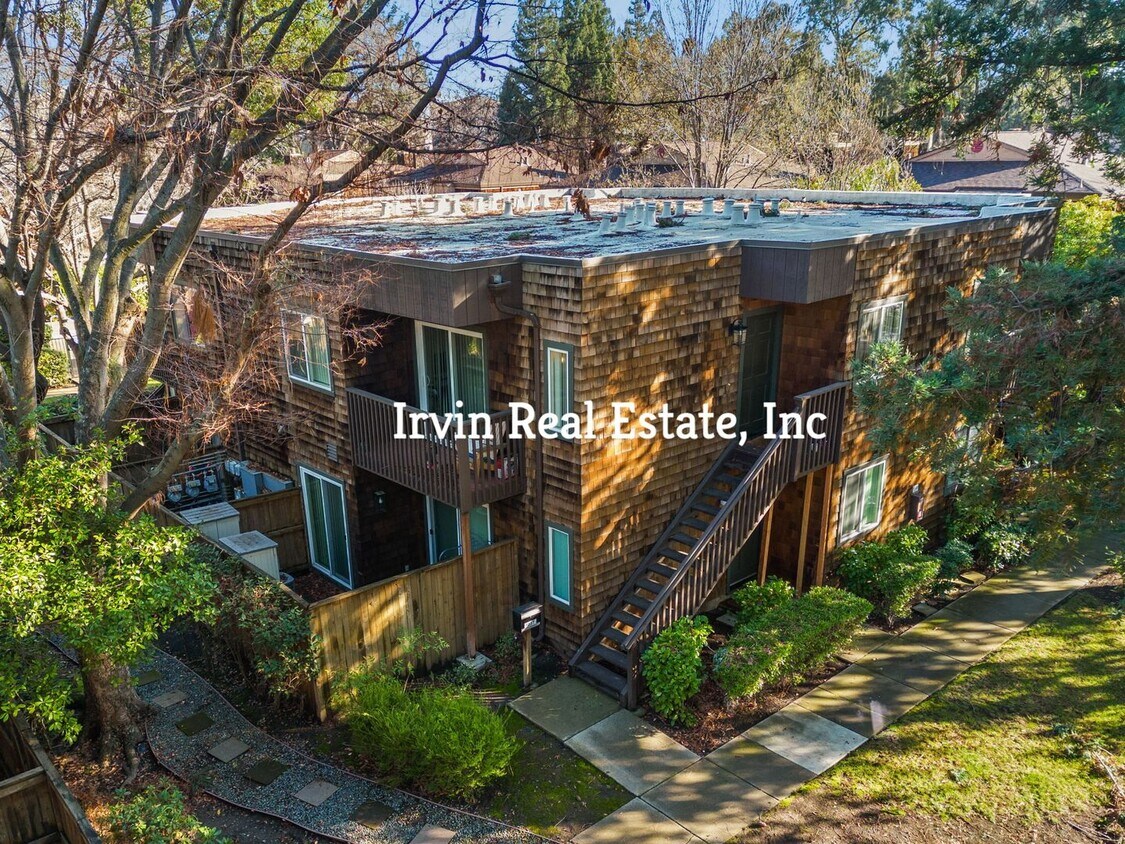
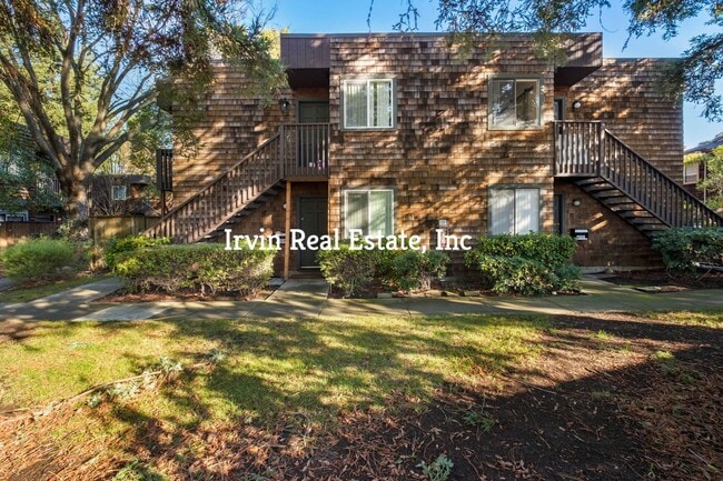
1238 Honey Trail
Walnut Creek, CA 94597
2 Weeks Ago
|
Edit
Favorites
1238 Honey Trail

Favorites
Check Back Soon for Upcoming Availability
| Beds | Baths | Average SF |
|---|---|---|
| 1 Bedroom 1 Bedroom 1 Br | 1 Bath 1 Bath 1 Ba | 708 SF |
About This Property
Cute 1 Bedroom and 1 Bath Condo in the quaint Honey Trail neighborhood. There is a living room and a dining room There is a sliding glass door to an outdoor patio with lots of storage. The unit has indoor laundry. The Honey Trail community has many beautiful common areas and a pool. 5 minute walk to BART. parks, hiking trails, shopping, restaurants, and more. Please visit our website for criteria and qualifications. To view it we will need one rental application. Section 8 Welcome
1238 Honey Trail is a condo located in Contra Costa County and the 94597 ZIP Code. This area is served by the Walnut Creek Elementary attendance zone.
Condo Features
- Dishwasher
Location
Get Directions
Nestled in the East Bay region of the San Francisco Bay Area, Walnut Creek combines suburban comfort with city amenities. The city encompasses 1,800 acres of open space, featuring Shell Ridge and Lime Ridge trails for hiking and outdoor recreation. Downtown Walnut Creek features Broadway Plaza shopping district, while the Lesher Center for the Arts hosts performances and cultural events. The rental market shows a 1.7% annual increase, with one-bedroom units averaging $2,476 and two-bedroom homes typically renting for $2,953. Notable areas include Parkmead, Walnut Heights, and the Northgate district.
Established in 1849 along what early settlers called "Nuts Creek," Walnut Creek has grown into a community of over 70,000 residents. The Mediterranean climate makes it ideal for exploring outdoor spaces like Heather Farm Park and the Ruth Bancroft Garden.
Learn more about living in Walnut Creek
Amenities
- Dishwasher
Education
| Colleges & Universities | Distance | ||
|---|---|---|---|
| Colleges & Universities | Distance | ||
| Drive: | 10 min | 4.1 mi | |
| Drive: | 19 min | 8.9 mi | |
| Drive: | 27 min | 16.0 mi | |
| Drive: | 26 min | 17.5 mi |
1238 Honey Trail is within 10 minutes or 4.1 miles from Diablo Valley, Pleasant Hill. It is also near Saint Marys Coll. of Calif. and Los Medanos College, Pittsburg.
Schools


Public Elementary School
Grades K-5
497 Students
Nearby
Public Elementary School
Grades K-5
356 Students
Attendance Zone
Public Middle School
Grades 6-8
985 Students
Attendance Zone
Public High School
Grades 9-12
1,571 Students
Attendance Zone
Private Elementary & Middle School
Grades PK-8
499 Students
Nearby
Private Elementary & Middle School
Grades PK-8
408 Students
Nearby
Private Middle & High School
Grades 6-12
49 Students
Nearby
School data provided by
 The GreatSchools Rating helps parents compare schools within a state based on a variety of school quality indicators and provides a helpful picture of how effectively each school serves all of its students. Ratings are on a scale of 1 (below average) to 10 (above average) and can include test scores, college readiness, academic progress, advanced courses, equity, discipline and attendance data. We also advise parents to visit schools, consider other information on school performance and programs, and consider family needs as part of the school selection process.
View GreatSchools Rating Methodology
Data provided by GreatSchools.org © 2025. All rights reserved.
View GreatSchools Rating Methodology
Data provided by GreatSchools.org © 2025. All rights reserved.
Transportation options available in Walnut Creek include Pleasant Hill Station, located 0.4 mile from 1238 Honey Trail. 1238 Honey Trail is near Metro Oakland International, located 25.8 miles or 37 minutes away, and San Francisco International, located 37.8 miles or 55 minutes away.
| Transit / Subway | Distance | ||
|---|---|---|---|
| Transit / Subway | Distance | ||
|
|
Walk: | 7 min | 0.4 mi |
|
|
Drive: | 5 min | 2.2 mi |
|
|
Drive: | 10 min | 5.0 mi |
|
|
Drive: | 9 min | 5.8 mi |
|
|
Drive: | 10 min | 6.6 mi |
| Commuter Rail | Distance | ||
|---|---|---|---|
| Commuter Rail | Distance | ||
|
|
Drive: | 15 min | 10.5 mi |
|
|
Drive: | 27 min | 17.2 mi |
|
|
Drive: | 26 min | 19.0 mi |
|
|
Drive: | 26 min | 19.3 mi |
|
|
Drive: | 30 min | 20.9 mi |
| Airports | Distance | ||
|---|---|---|---|
| Airports | Distance | ||
|
Metro Oakland International
|
Drive: | 37 min | 25.8 mi |
|
San Francisco International
|
Drive: | 55 min | 37.8 mi |
Time and distance from 1238 Honey Trail.
| Shopping Centers | Distance | ||
|---|---|---|---|
| Shopping Centers | Distance | ||
| Walk: | 4 min | 0.2 mi | |
| Walk: | 12 min | 0.6 mi | |
| Walk: | 14 min | 0.7 mi |
1238 Honey Trail has 3 shopping centers within 0.7 mile, which is about a 14-minute walk. The miles and minutes will be for the farthest away property.
| Parks and Recreation | Distance | ||
|---|---|---|---|
| Parks and Recreation | Distance | ||
|
The Ruth Bancroft Garden
|
Drive: | 4 min | 1.4 mi |
|
Larkey Park
|
Drive: | 4 min | 1.5 mi |
|
Lindsay Wildlife Museum
|
Drive: | 4 min | 1.6 mi |
|
Heather Farm Park
|
Drive: | 6 min | 2.0 mi |
|
Gardens at Heather Farm
|
Drive: | 6 min | 2.2 mi |
1238 Honey Trail has 5 parks within 2.2 miles, including Gardens at Heather Farm, Heather Farm Park, and The Ruth Bancroft Garden.
| Hospitals | Distance | ||
|---|---|---|---|
| Hospitals | Distance | ||
| Drive: | 5 min | 2.1 mi | |
| Drive: | 7 min | 3.0 mi | |
| Drive: | 9 min | 5.5 mi |
1238 Honey Trail has 3 hospitals within 5.5 miles, the nearest is John Muir Medical Center - Walnut Creek Campus which is 2.1 miles away and a 5 minute drive.
You May Also Like
Similar Rentals Nearby


What Are Walk Score®, Transit Score®, and Bike Score® Ratings?
Walk Score® measures the walkability of any address. Transit Score® measures access to public transit. Bike Score® measures the bikeability of any address.
What is a Sound Score Rating?
A Sound Score Rating aggregates noise caused by vehicle traffic, airplane traffic and local sources

1238 Honey Trail
Walnut Creek, CA 94597