

$1,000
/ Month
1235 W Hazzard St
Philadelphia, PA 19133
2 Weeks Ago
|
Edit
Favorites
-
Bedrooms
2
-
Bathrooms
1
-
Square Feet
1,024 sq ft
1235 W Hazzard St

Favorites
About This Home
$1,000 deposit
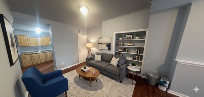
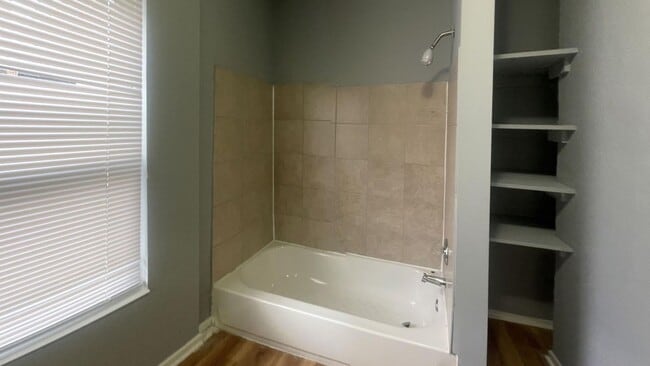
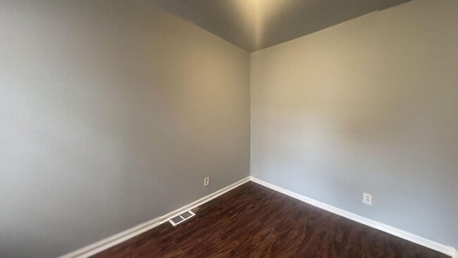
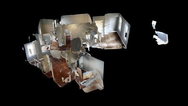
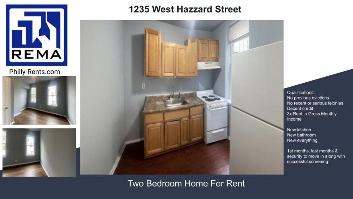
Virtual Tour: This Philadelphia residence at 1235 W Hazzard St offers a thoughtful layout across two floors, totaling 610 sq. ft. The ground floor spans 310 sq. ft., while the upper level provides 300 sq. ft. of living space. The home features two bedrooms, including a spacious primary bedroom of 160 sq. ft., and one bathroom. The interior boasts modern finishes throughout, with a cohesive color scheme of soft gray walls and rich, dark wood flooring. Large windows in the bedrooms allow ample natural light, creating a bright and airy atmosphere. The kitchen, though compact, is efficiently designed with wooden cabinetry, a granite-like countertop, and essential appliances including a sink and stove. The bathroom features a full-sized bathtub with tiled surroundings, demonstrating a practical use of space. The overall design aesthetic is clean and contemporary, with attention to detail evident in elements like the white baseboards that contrast nicely with the flooring. This property combines functionality with style, making efficient use of its 610 sq. ft. to provide comfortable urban living in the heart of Philadelphia. Qualifications / General Screening Criteria: • Rental applications must be complete, correct and verified. • Gross monthly income must provable and be at least 3 times rent or tenant must have a housing choice voucher. • Applicants must have a proven history of on-time rental payments not including the COVID-19 emergency period. • Applicants must have a good relevant credit history or tenant must have a housing choice voucher. • Applicants must have no evictions in the last 4 years except during the COVID-19 emergency period.
1235 W Hazzard St is a house located in Philadelphia County and the 19133 ZIP Code. This area is served by the The School District of Philadelphia attendance zone.
* Price shown is base rent. Excludes user-selected optional fees and variable or usage-based fees and required charges due at or prior to move-in or at move-out. Price, availability, fees, and any applicable rent special are subject to change without notice.
* Square footage definitions vary. Displayed square footage is approximate.
Contact
- Listed by Real | Real Estate Management Advisors LLC
Location
Get Directions
Not to be confused with Northeast Philadelphia, North Philadelphia East encompasses the smaller subsets of Ludlow, Yorktown, West Kensington, Poplar, and Callowhill. This composite area runs from the Vine Street Expressway, stretching north to Erie Avenue. Broad Street acts as its eastern border, and the western edge runs a jagged line separating North Philadelphia East from the nearby Kensington, Port Richmond, and Fishtown neighborhoods. With such a long stretch of city, the neighborhood offers a diverse blend of important city landmarks, such as renowned musical venues the Electric Factory and Union Transfer, and Temple University, North Philadelphia's premiere site of higher learning.
Learn more about living in North Philadelphia East
Education
| Colleges & Universities | Distance | ||
|---|---|---|---|
| Colleges & Universities | Distance | ||
| Drive: | 3 min | 1.3 mi | |
| Drive: | 4 min | 1.4 mi | |
| Drive: | 6 min | 2.7 mi | |
| Drive: | 8 min | 2.8 mi |
1235 W Hazzard St is within 3 minutes or 1.3 miles from Temple University, Main Campus. It is also near Temple Univ., Health Center and C.C. of Philadelphia.
Schools


Public Elementary & Middle School
Grades PK-8
355 Students
Nearby
Charter Elementary School
Grades K-6
448 Students
Attendance Zone
Charter Middle & High School
Grades 7-12
1,160 Students
Attendance Zone
Private Elementary & Middle School
Grades 5-8
52 Students
Nearby
Private High School
Grades 9-12
Nearby
School data provided by
 The GreatSchools Rating helps parents compare schools within a state based on a variety of school quality indicators and provides a helpful picture of how effectively each school serves all of its students. Ratings are on a scale of 1 (below average) to 10 (above average) and can include test scores, college readiness, academic progress, advanced courses, equity, discipline and attendance data. We also advise parents to visit schools, consider other information on school performance and programs, and consider family needs as part of the school selection process.
View GreatSchools Rating Methodology
Data provided by GreatSchools.org © 2025. All rights reserved.
View GreatSchools Rating Methodology
Data provided by GreatSchools.org © 2025. All rights reserved.
Transportation options available in Philadelphia include Susquehanna-Dauphin, located 0.5 mile from 1235 W Hazzard St. 1235 W Hazzard St is near Philadelphia International, located 14.8 miles or 27 minutes away, and Trenton Mercer, located 33.1 miles or 50 minutes away.
| Transit / Subway | Distance | ||
|---|---|---|---|
| Transit / Subway | Distance | ||
|
|
Walk: | 9 min | 0.5 mi |
|
|
Drive: | 3 min | 1.2 mi |
|
|
Drive: | 3 min | 1.2 mi |
|
|
Drive: | 5 min | 1.6 mi |
|
|
Drive: | 5 min | 1.9 mi |
| Commuter Rail | Distance | ||
|---|---|---|---|
| Commuter Rail | Distance | ||
|
|
Walk: | 7 min | 0.4 mi |
|
|
Walk: | 7 min | 0.4 mi |
|
|
Walk: | 18 min | 0.9 mi |
|
|
Drive: | 4 min | 1.3 mi |
|
|
Drive: | 5 min | 2.0 mi |
| Airports | Distance | ||
|---|---|---|---|
| Airports | Distance | ||
|
Philadelphia International
|
Drive: | 27 min | 14.8 mi |
|
Trenton Mercer
|
Drive: | 50 min | 33.1 mi |
Time and distance from 1235 W Hazzard St.
| Shopping Centers | Distance | ||
|---|---|---|---|
| Shopping Centers | Distance | ||
| Walk: | 11 min | 0.6 mi | |
| Walk: | 13 min | 0.7 mi | |
| Drive: | 4 min | 1.4 mi |
1235 W Hazzard St has 3 shopping centers within 1.4 miles, which is about a 4-minute drive. The miles and minutes will be for the farthest away property.
| Parks and Recreation | Distance | ||
|---|---|---|---|
| Parks and Recreation | Distance | ||
|
Wagner Free Institute of Science
|
Drive: | 4 min | 1.3 mi |
|
Edgar Allan Poe Nat'l Historic Site
|
Drive: | 7 min | 2.3 mi |
|
The Academy of Natural Sciences
|
Drive: | 7 min | 3.2 mi |
|
Franklin Institute
|
Drive: | 8 min | 3.5 mi |
|
Fels Planetarium
|
Drive: | 8 min | 3.5 mi |
1235 W Hazzard St has 5 parks within 3.5 miles, including Wagner Free Institute of Science, Edgar Allan Poe Nat'l Historic Site, and The Academy of Natural Sciences.
| Hospitals | Distance | ||
|---|---|---|---|
| Hospitals | Distance | ||
| Drive: | 4 min | 1.5 mi | |
| Drive: | 4 min | 1.7 mi | |
| Drive: | 6 min | 2.3 mi |
1235 W Hazzard St has 3 hospitals within 2.3 miles, the nearest is Temple University Hospital which is 1.5 miles away and a 4 minute drive.
| Military Bases | Distance | ||
|---|---|---|---|
| Military Bases | Distance | ||
| Drive: | 17 min | 9.2 mi |
1235 W Hazzard St is 9.2 miles and a 17 minute drive from Philadelphia Naval Busi Center.
You May Also Like
Similar Rentals Nearby


What Are Walk Score®, Transit Score®, and Bike Score® Ratings?
Walk Score® measures the walkability of any address. Transit Score® measures access to public transit. Bike Score® measures the bikeability of any address.
What is a Sound Score Rating?
A Sound Score Rating aggregates noise caused by vehicle traffic, airplane traffic and local sources
1235 W Hazzard St
Philadelphia, PA 19133