
$1,625 / Month
1235 S Westgate Ave
Los Angeles, CA 90025
2 Weeks Ago
Favorites
1235 S Westgate Ave

Favorites
Check Back Soon for Upcoming Availability
| Beds | Baths | Average SF |
|---|---|---|
| Studio Studio 0 Br | 1 Bath 1 Bath 1 Ba | — |
About This Property
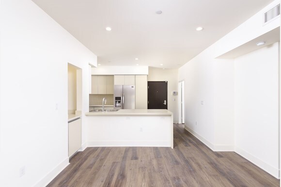
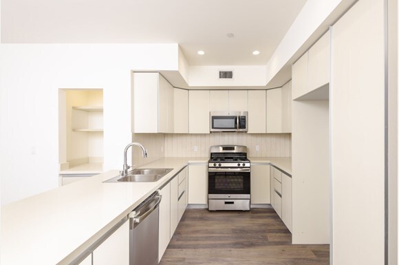
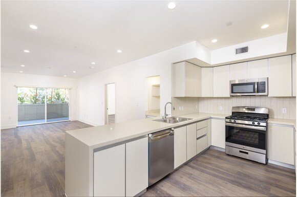
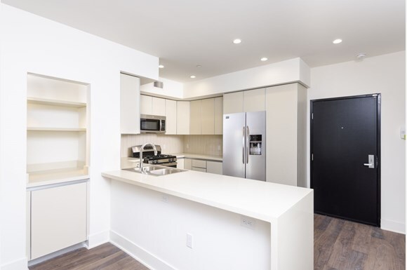
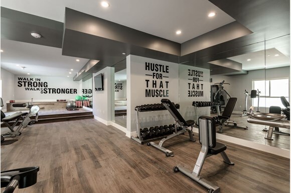
ROOM FOR RENT! Private Bedroom and Bathroom in a Shared Living Apartment. Facilities: Private room fully furnished with a bed, bed frame, desk, chair, bookshelf, floor lamp. Common area and kitchen are shared with Free Gym Access. Roommates: This is a Shared Living Apartment. Everyone in the house shares a kitchen, common areas, and a living room. Neighborhood: Westwood is a commercial and residential neighborhood in the northern central portion of the Westside region of Los Angeles, California. It is the home of the University of California, Los Angeles (UCLA). The 2000 census found the forty-seven thousand people living in the neighborhood were generally young and moderately diverse ethnically, with a generally high level of income and education. For young people with high aspirations for life, this is definitely a spot where your heart could belong. UCLA Transportation: Super close to 405, which can take to UCLA and Smc area quickly. Bus stations are right at the corner, quite a lot of lines which can take you to most of the destinations in LA. If you like biking or jogging, just take the Santa Monica Blvd and it takes you right to the beach. FRIENDLY REMINDERS: Bedding's, pillows, bedding decor, utensils, and some appliances are NOT INCLUDED just for picture decoration purposes only!! All images used are for illustrative purposes. These and the dimensions are given are illustrative for this Apartment and individual properties may differ.
1235 S Westgate Ave is a townhome located in Los Angeles County and the 90025 ZIP Code. This area is served by the Los Angeles Unified attendance zone.
Location
Get Directions
There are numerous nicknames for Los Angeles, just as there are various vibes within this sprawling city. Between rugged mountains and sandy shorelines, a laid-back surf culture and a high-powered commercial district, and food trucks and some of the world’s top-rated restaurants, Los Angeles features diversity in every aspect possible. Somehow, all the pieces of this city fit together seamlessly, making Los Angeles the unique destination we know and love. From Rodeo Drive and Beverly Hills to Hollywood and Chinatown, there is the perfect neighborhood for everyone in Los Angeles.
From celebrity sightings to unbeatable shopping destinations, Los Angeles is hard to beat. Enjoy a hike in the Santa Monica Mountains, Griffith Park, or Topanga State Park, enjoy the famous entertainment at Universal Studios Hollywood, see the stars along the legendary Hollywood Walk of Fame, or stop into the Los Angeles County Museum of Art.
Learn more about living in Los Angeles
Education
| Colleges & Universities | Distance | ||
|---|---|---|---|
| Colleges & Universities | Distance | ||
| Drive: | 4 min | 1.6 mi | |
| Drive: | 6 min | 2.2 mi | |
| Drive: | 8 min | 2.9 mi | |
| Drive: | 8 min | 3.0 mi |
1235 S Westgate Ave is within 4 minutes or 1.6 miles from Santa Monica Coll., Academy. It is also near UCLA and The Art Inst., Los Angeles.
Schools


Public Elementary School
Grades K-5
403 Students
Nearby
Public Elementary School
Grades K-5
214 Students
Attendance Zone
Charter Middle School
Grades 6-8
492 Students
Attendance Zone
Charter High School
Grades 9-12
1,338 Students
Attendance Zone
Private Elementary & Middle School
Grades PK-8
158 Students
Nearby
Private Middle & High School
Grades 6-12
16 Students
Nearby
School data provided by
 The GreatSchools Rating helps parents compare schools within a state based on a variety of school quality indicators and provides a helpful picture of how effectively each school serves all of its students. Ratings are on a scale of 1 (below average) to 10 (above average) and can include test scores, college readiness, academic progress, advanced courses, equity, discipline and attendance data. We also advise parents to visit schools, consider other information on school performance and programs, and consider family needs as part of the school selection process.
View GreatSchools Rating Methodology
Data provided by GreatSchools.org © 2025. All rights reserved.
View GreatSchools Rating Methodology
Data provided by GreatSchools.org © 2025. All rights reserved.
Transportation options available in Los Angeles include Expo/Bundy, located 1.6 miles from 1235 S Westgate Ave. 1235 S Westgate Ave is near Los Angeles International, located 10.7 miles or 17 minutes away, and Bob Hope, located 18.2 miles or 28 minutes away.
| Transit / Subway | Distance | ||
|---|---|---|---|
| Transit / Subway | Distance | ||
|
|
Drive: | 4 min | 1.6 mi |
|
|
Drive: | 6 min | 2.4 mi |
|
|
Drive: | 7 min | 2.5 mi |
| Drive: | 6 min | 3.0 mi | |
|
|
Drive: | 8 min | 3.7 mi |
| Commuter Rail | Distance | ||
|---|---|---|---|
| Commuter Rail | Distance | ||
|
|
Drive: | 21 min | 14.6 mi |
|
|
Drive: | 28 min | 18.2 mi |
|
|
Drive: | 29 min | 19.0 mi |
|
|
Drive: | 27 min | 19.0 mi |
| Drive: | 29 min | 19.1 mi |
| Airports | Distance | ||
|---|---|---|---|
| Airports | Distance | ||
|
Los Angeles International
|
Drive: | 17 min | 10.7 mi |
|
Bob Hope
|
Drive: | 28 min | 18.2 mi |
Time and distance from 1235 S Westgate Ave.
| Shopping Centers | Distance | ||
|---|---|---|---|
| Shopping Centers | Distance | ||
| Walk: | 3 min | 0.2 mi | |
| Walk: | 3 min | 0.2 mi | |
| Walk: | 6 min | 0.3 mi |
1235 S Westgate Ave has 3 shopping centers within 0.3 mile, which is about a 6-minute walk. The miles and minutes will be for the farthest away property.
| Parks and Recreation | Distance | ||
|---|---|---|---|
| Parks and Recreation | Distance | ||
|
Mathias Botanical Garden
|
Drive: | 5 min | 2.0 mi |
|
Hannah Carter Japanese Garden
|
Drive: | 10 min | 3.6 mi |
|
Santa Monica Pier Aquarium
|
Drive: | 10 min | 4.2 mi |
|
Santa Monica State Beach
|
Drive: | 10 min | 4.5 mi |
|
Will Rogers State Historic Park
|
Drive: | 15 min | 5.5 mi |
1235 S Westgate Ave has 5 parks within 5.5 miles, including Mathias Botanical Garden, Santa Monica State Beach, and Hannah Carter Japanese Garden.
| Hospitals | Distance | ||
|---|---|---|---|
| Hospitals | Distance | ||
| Drive: | 4 min | 1.7 mi | |
| Drive: | 6 min | 2.0 mi | |
| Drive: | 6 min | 2.1 mi |
1235 S Westgate Ave has 3 hospitals within 2.1 miles, the nearest is Providence Saint John's Health Center which is 1.7 miles away and a 4 minute drive.
| Military Bases | Distance | ||
|---|---|---|---|
| Military Bases | Distance | ||
| Drive: | 18 min | 13.3 mi |
1235 S Westgate Ave is 13.3 miles and a 18 minute drive from Los Angeles Air Force Base.
You May Also Like
Similar Rentals Nearby


What Are Walk Score®, Transit Score®, and Bike Score® Ratings?
Walk Score® measures the walkability of any address. Transit Score® measures access to public transit. Bike Score® measures the bikeability of any address.
What is a Sound Score Rating?
A Sound Score Rating aggregates noise caused by vehicle traffic, airplane traffic and local sources
1235 S Westgate Ave
Los Angeles, CA 90025