

$2,100 / Month
12330 Shropshire Blvd
Austin, TX 78753
Today
Favorites
512-775-3965
-
Bedrooms
3
-
Bathrooms
2
-
Square Feet
1,247 sq ft
-
Available
Available Now
Highlights
- Pets Allowed
- Hardwood Floors
12330 Shropshire Blvd

Favorites
About This Home
Available Now
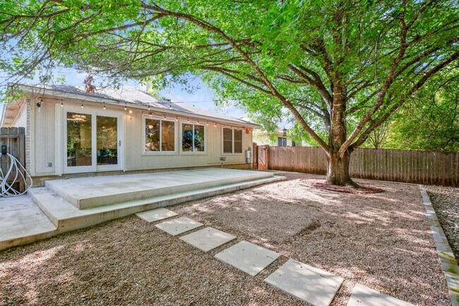
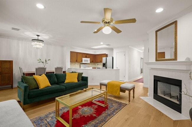
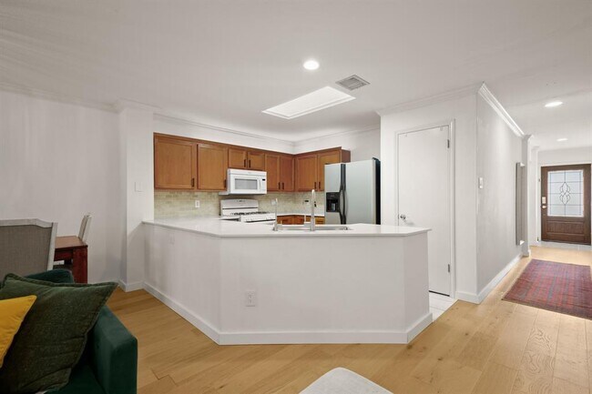
Open floorplan with updated kitchen quartz counter tops overlooking large family and dining areas with views of a gorgeous tree covered, low-maintenance backyard recently updated with extended patio, rock work and terracing. Updated hardwood flooring throughout. No carpet! Primary bedroom at rear of house with two showers, walk in closet & dual vanity. MIL plan with additional two beds/full bath at front. No HOA. Some SMART home features. Pflugerville ISD. Close to major employers, shopping & I-35. Renter to verify all schools. Pets considered, max 2, $250 pet deposit+$250 non refundable pet fee, per pet. Cats/dogs only. No aquatic tanks. Renter's Insurance required.
12330 Shropshire Blvd is a house located in Travis County and the 78753 ZIP Code. This area is served by the Pflugerville Independent attendance zone.
* Price shown is base rent and may not include non-optional fees and utilities.
Price, availability, fees, and any applicable rent special are subject to change without notice.
* Square footage definitions vary. Displayed square footage is approximate.
House Features
Dishwasher
Hardwood Floors
Microwave
Refrigerator
- Dishwasher
- Microwave
- Refrigerator
- Hardwood Floors
- Tile Floors
Fees and Policies
The fees below are based on community-supplied data and may exclude additional fees and utilities.
- Dogs Allowed
-
Fees not specified
- Cats Allowed
-
Fees not specified
Contact
- Listed by Mark Storer | Compass RE Texas, LLc
- Phone Number
- Contact
-
Source
 Austin Board of REALTORS®
The information included in this listing is provided exclusively for consumers’ personal, non-commercial use and may not be used for any purpose other than to identify prospective properties consumers may be interested in purchasing. The information on each listing is furnished by the owner and deemed reliable to the best of his/her knowledge, but should be verified by the purchaser. ABoR, ACTRIS and Estately assume no responsibility for typographical errors, misprints or misinformation. This property listing is offered without respect to any protected classes in accordance with the law. Copyright © 2025.
Location
Get Directions
Amenities
- Dishwasher
- Microwave
- Refrigerator
- Hardwood Floors
- Tile Floors
Extending northward from Parmer Lane to Howard Lane, and from I-35 on the west side to Harris Ridge Road on the east, Parmer includes the smaller communities of Parmer Center, Tech Ridge Center, Parmer North, Dell Parmer South Campus, and crossing at Parmer Lane. The Parmer neighborhood is about 10 miles northeast of Downtown Austin and nine miles from the University of Texas at Austin.
Parmer contains several shopping plazas along I-35, with plenty of additional businesses scattered throughout this busy area. Nearby parks include Walnut Creek Metropolitan Park and Stoney Creek Park, both of which provide hiking trails and picnic areas. Walnut Creek includes the Walnut Creek Municipal Pool and the BMX Pump Track.
Learn more about living in Parmer
Education
| Colleges & Universities | Distance | ||
|---|---|---|---|
| Colleges & Universities | Distance | ||
| Drive: | 10 min | 4.5 mi | |
| Drive: | 13 min | 7.4 mi | |
| Drive: | 16 min | 9.9 mi | |
| Drive: | 20 min | 11.5 mi |
12330 Shropshire Blvd is within 10 minutes or 4.5 miles from Austin C.C., Northridge Campus. It is also near The Art Institute of Austin and University of Texas at Austin.
Schools


Public Elementary School
Grades PK-5
502 Students
Attendance Zone
Public Middle School
Grades 6-8
718 Students
Attendance Zone
Public High School
Grades 9-12
1,663 Students
Attendance Zone
Private Elementary School
Grades PK-5
53 Students
Nearby
Private Elementary, Middle & High School
Grades PK-12
651 Students
Nearby
School data provided by
 The GreatSchools Rating helps parents compare schools within a state based on a variety of school quality indicators and provides a helpful picture of how effectively each school serves all of its students. Ratings are on a scale of 1 (below average) to 10 (above average) and can include test scores, college readiness, academic progress, advanced courses, equity, discipline and attendance data. We also advise parents to visit schools, consider other information on school performance and programs, and consider family needs as part of the school selection process.
View GreatSchools Rating Methodology
Data provided by GreatSchools.org © 2025. All rights reserved.
View GreatSchools Rating Methodology
Data provided by GreatSchools.org © 2025. All rights reserved.
Transportation options available in Austin include Kramer Station, located 5.3 miles from 12330 Shropshire Blvd. 12330 Shropshire Blvd is near Austin-Bergstrom International, located 19.9 miles or 34 minutes away.
| Transit / Subway | Distance | ||
|---|---|---|---|
| Transit / Subway | Distance | ||
| Drive: | 11 min | 5.3 mi | |
| Drive: | 12 min | 5.6 mi | |
| Drive: | 12 min | 5.9 mi | |
| Drive: | 13 min | 6.8 mi | |
| Drive: | 12 min | 6.9 mi |
| Commuter Rail | Distance | ||
|---|---|---|---|
| Commuter Rail | Distance | ||
|
|
Drive: | 21 min | 12.6 mi |
|
|
Drive: | 34 min | 22.8 mi |
| Airports | Distance | ||
|---|---|---|---|
| Airports | Distance | ||
|
Austin-Bergstrom International
|
Drive: | 34 min | 19.9 mi |
Time and distance from 12330 Shropshire Blvd.
| Shopping Centers | Distance | ||
|---|---|---|---|
| Shopping Centers | Distance | ||
| Walk: | 9 min | 0.5 mi | |
| Drive: | 4 min | 1.7 mi | |
| Drive: | 4 min | 1.8 mi |
12330 Shropshire Blvd has 3 shopping centers within 1.8 miles, which is about a 4-minute walk. The miles and minutes will be for the farthest away property.
| Parks and Recreation | Distance | ||
|---|---|---|---|
| Parks and Recreation | Distance | ||
|
Copperfield Nature Trail and Park
|
Walk: | 8 min | 0.4 mi |
|
Jourdan-Bachman Pioneer Farms
|
Drive: | 5 min | 1.9 mi |
|
Walnut Creek Park
|
Drive: | 5 min | 2.2 mi |
|
Balcones District Park
|
Drive: | 12 min | 5.8 mi |
|
The Stephen F. Austin Planetarium
|
Drive: | 14 min | 7.1 mi |
12330 Shropshire Blvd has 5 parks within 7.1 miles, including Copperfield Nature Trail and Park, Jourdan-Bachman Pioneer Farms, and Walnut Creek Park.
| Hospitals | Distance | ||
|---|---|---|---|
| Hospitals | Distance | ||
| Drive: | 9 min | 4.3 mi | |
| Drive: | 10 min | 5.1 mi | |
| Drive: | 15 min | 7.4 mi |
12330 Shropshire Blvd has 3 hospitals within 7.4 miles, the nearest is Cross Creek Hospital which is 4.3 miles away and a 9 minute drive.
| Military Bases | Distance | ||
|---|---|---|---|
| Military Bases | Distance | ||
| Drive: | 82 min | 65.1 mi | |
| Drive: | 95 min | 76.7 mi |
12330 Shropshire Blvd is 65.1 miles from Fort Hood, and is convenient to other military bases, including Randolph Air Force Base.
You May Also Like
Similar Rentals Nearby


What Are Walk Score®, Transit Score®, and Bike Score® Ratings?
Walk Score® measures the walkability of any address. Transit Score® measures access to public transit. Bike Score® measures the bikeability of any address.
What is a Sound Score Rating?
A Sound Score Rating aggregates noise caused by vehicle traffic, airplane traffic and local sources
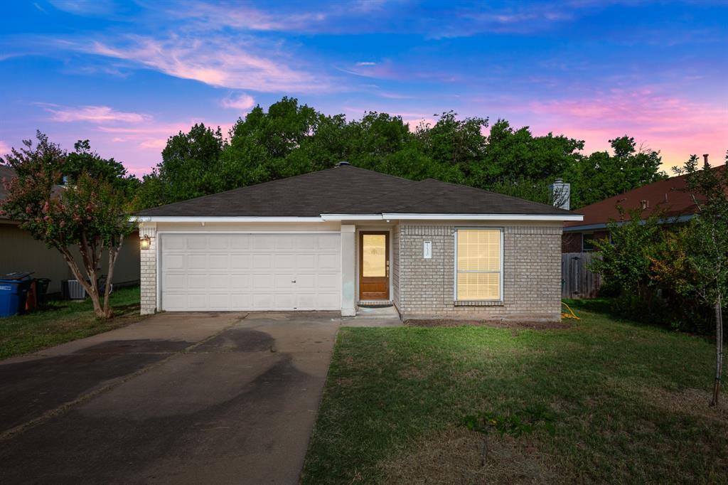
12330 Shropshire Blvd
Austin, TX 78753