
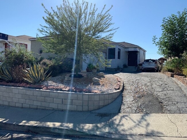
1233 Atwood St
Los Angeles, CA 90063
-
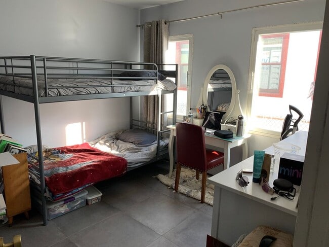
Bedrooms
2
-
Bathrooms
1
-
Square Feet
903 sq ft
-
Available
Available Jul 1
Highlight
- Pets Allowed

About This Home
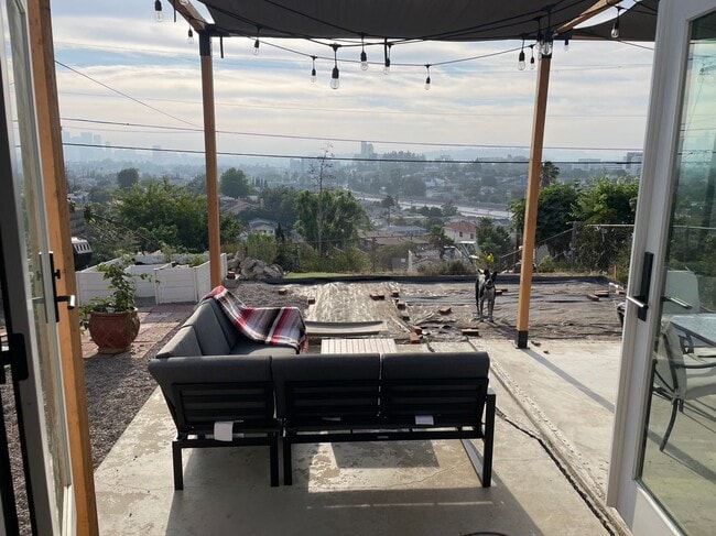
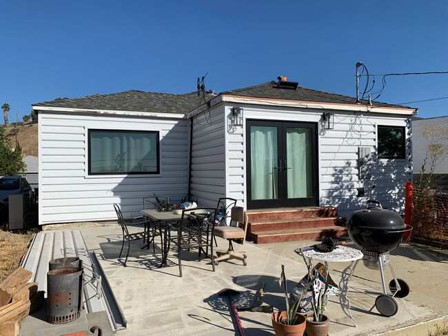
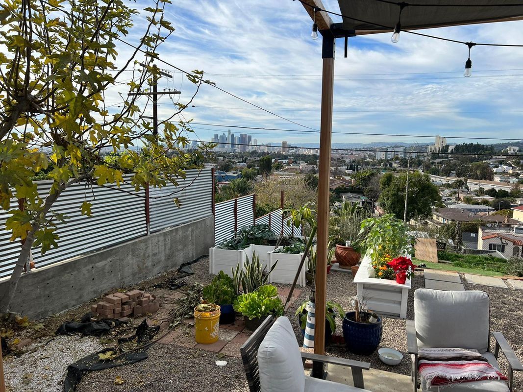
Welcome to your future home in Boyle Heights! This charming 2-bedroom, 1-bath single-family residence offers 903 square feet of cozy living space perfect for individuals or small families. Enjoy the modern kitchen with stainless steel appliances, including a Electric range, paired with ample counter space and open shelving. The comfortable living room features large windows that invite in plenty of natural light, and the updated bathroom boasts contemporary fixtures. Step outside to a spacious outdoor patio with a lovely city skyline view, complete with a covered seating area adorned with string lights, ideal for evenings of relaxation. Conveniently, this home comes with a dedicated parking spot and includes essential unit amenities like a washer and dryer. With nearby parks and a number of excellent restaurants just moments away, this location offers both convenience and community. Don’t miss your chance to experience this lovely home—schedule a viewing today!
1233 Atwood St is a house located in Los Angeles County and the 90063 ZIP Code. This area is served by the Los Angeles Unified attendance zone.
House Features
- Washer/Dryer
- Dishwasher
- Refrigerator
- Renters Insurance Program
Fees and Policies
The fees below are based on community-supplied data and may exclude additional fees and utilities.
- Dogs Allowed
-
Fees not specified
- Cats Allowed
-
Fees not specified
- Parking
-
Other--Assigned Parking
Details
Lease Options
-
12 Months
Contact
- Phone Number
- Website View Property Website
- Contact
-
Source

- Washer/Dryer
- Dishwasher
- Refrigerator
- Renters Insurance Program
Southeast Los Angeles is directly south of the Fashion District and east of the University of Southern California (USC). This large neighborhood is minutes from downtown Los Angeles, Hollywood, and Beverly Hills, with easy access to the 110 Freeway. This great location places you near sunny beaches, nature trails, and a bevy of leading employers. Students can access both USC and California State University Long Beach from their Southeast LA apartment.
This densely populated, diverse neighborhood features everything from food trucks and corner markets to wide sidewalks and residential areas filled with bungalows, ranch, and Spanish Colonial architecture. Southeast LA features palm trees and mountain views, tampered with gritty undertones to give it a cool, funky vibe.
As for outdoor fun, take your pick between Catalina Island, Venus Beach, or the Santa Monica Pier. Nearby, you’ll find more sunny beaches like White Point, Cabrillo, and Long Beach.
Learn more about living in Southeast Los Angeles| Colleges & Universities | Distance | ||
|---|---|---|---|
| Colleges & Universities | Distance | ||
| Drive: | 5 min | 1.7 mi | |
| Drive: | 6 min | 2.6 mi | |
| Drive: | 8 min | 3.5 mi | |
| Drive: | 11 min | 6.5 mi |


View GreatSchools Rating Methodology
Data provided by GreatSchools.org © 2025. All rights reserved.
Transportation options available in Los Angeles include Soto Station, located 1.8 miles from 1233 Atwood St. 1233 Atwood St is near Bob Hope, located 17.9 miles or 26 minutes away, and Los Angeles International, located 20.0 miles or 33 minutes away.
| Transit / Subway | Distance | ||
|---|---|---|---|
| Transit / Subway | Distance | ||
| Drive: | 4 min | 1.8 mi | |
| Drive: | 5 min | 2.1 mi | |
| Drive: | 5 min | 2.4 mi | |
| Drive: | 7 min | 2.9 mi | |
| Drive: | 7 min | 3.0 mi |
| Commuter Rail | Distance | ||
|---|---|---|---|
| Commuter Rail | Distance | ||
| Drive: | 7 min | 3.2 mi | |
|
|
Drive: | 8 min | 4.6 mi |
| Drive: | 14 min | 6.6 mi | |
| Drive: | 14 min | 7.7 mi | |
| Drive: | 11 min | 8.6 mi |
| Airports | Distance | ||
|---|---|---|---|
| Airports | Distance | ||
|
Bob Hope
|
Drive: | 26 min | 17.9 mi |
|
Los Angeles International
|
Drive: | 33 min | 20.0 mi |
Time and distance from 1233 Atwood St.
| Shopping Centers | Distance | ||
|---|---|---|---|
| Shopping Centers | Distance | ||
| Drive: | 5 min | 1.5 mi | |
| Drive: | 5 min | 2.0 mi | |
| Drive: | 5 min | 2.1 mi |
| Parks and Recreation | Distance | ||
|---|---|---|---|
| Parks and Recreation | Distance | ||
|
Hollenbeck Lake
|
Drive: | 6 min | 2.4 mi |
|
Audubon Center at Debs Park
|
Drive: | 11 min | 5.2 mi |
|
Elysian Park
|
Drive: | 14 min | 5.3 mi |
|
Chavez Ravine Arboretum
|
Drive: | 11 min | 6.2 mi |
|
Vista Hermosa Natural Park
|
Drive: | 11 min | 6.3 mi |
| Hospitals | Distance | ||
|---|---|---|---|
| Hospitals | Distance | ||
| Drive: | 5 min | 1.7 mi | |
| Drive: | 5 min | 2.0 mi | |
| Drive: | 7 min | 3.1 mi |
| Military Bases | Distance | ||
|---|---|---|---|
| Military Bases | Distance | ||
| Drive: | 31 min | 22.2 mi | |
| Drive: | 36 min | 23.8 mi |
You May Also Like
What Are Walk Score®, Transit Score®, and Bike Score® Ratings?
Walk Score® measures the walkability of any address. Transit Score® measures access to public transit. Bike Score® measures the bikeability of any address.
What is a Sound Score Rating?
A Sound Score Rating aggregates noise caused by vehicle traffic, airplane traffic and local sources
1233 Atwood St
Los Angeles, CA 90063