

$7,500
/ Month
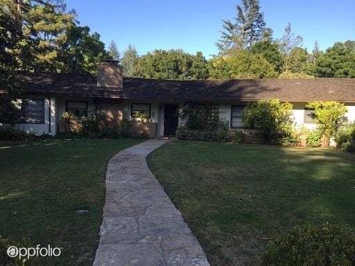
123 Hawthorne Dr
Atherton, CA 94027
2 Weeks Ago
|
Edit
Favorites
123 Hawthorne Dr

Favorites
Check Back Soon for Upcoming Availability
| Beds | Baths | Average SF |
|---|---|---|
| 4 Bedrooms 4 Bedrooms 4 Br | 3 Baths 3 Baths 3 Ba | 2,160 SF |
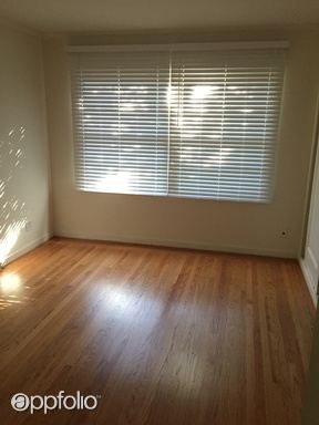
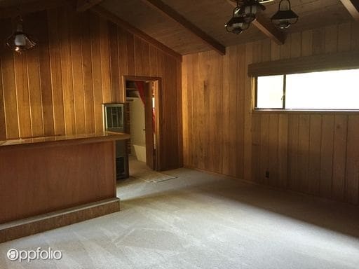
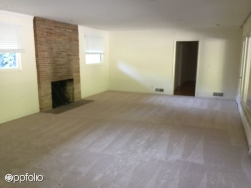
About This Property
(650) 521-2001 - Ranch style home in Lindenwood with pool plus additional pool house with mini bar and bathroom. Pool and monthly garden service included. Pets ok (RLNE1861822)
123 Hawthorne Dr is a house located in San Mateo County and the 94027 ZIP Code. This area is served by the Menlo Park City Elementary attendance zone.
Location
Get Directions
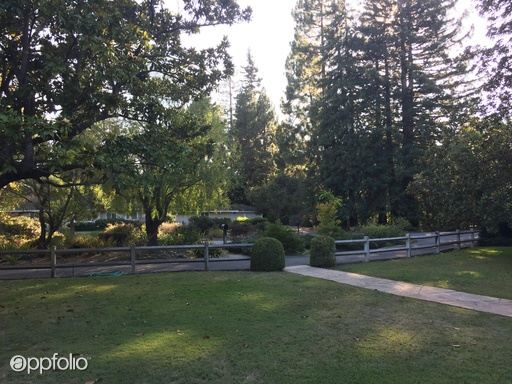
Minutes north of the Stanford University campus and just a couple blocks from the 101, Lindenwood is a charming suburban community offering something for all walks of life. The local division of the Palo Alto VA Hospital sits just a few blocks east of the neighborhood, making it a highly convenient location for healthcare professional.
Trees and greenery surround you everywhere in the neighborhood, particularly in public recreation areas like Flood Park and Holbrook-Palmer Park, which feature networks of trails that are perfect for jogging or just a leisurely stroll through the foliage. Numerous public and private schools can be found throughout the community and just beyond, giving students the option to walk to class easily.
In addition to the local bus system, rail service from Menlo Park Station makes it easy to get to work without a personal vehicle – be sure to grab a cup of coffee at Café Borrone before you catch your train.
Learn more about living in LindenwoodBelow are rent ranges for similar nearby apartments
Education
| Colleges & Universities | Distance | ||
|---|---|---|---|
| Colleges & Universities | Distance | ||
| Drive: | 4 min | 1.4 mi | |
| Drive: | 13 min | 4.7 mi | |
| Drive: | 17 min | 7.0 mi | |
| Drive: | 15 min | 8.6 mi |
123 Hawthorne Dr is within 4 minutes or 1.4 miles from Menlo College. It is also near Stanford University and Foothill College, Middlefield.
Schools


Public Elementary School
Grades K-5
270 Students
Nearby
Public Elementary School
Grades K-5
602 Students
Attendance Zone
Public Middle School
Grades 6-8
867 Students
Attendance Zone
Public High School
Grades 9-12
2,125 Students
Attendance Zone
Private Elementary & Middle School
Grades PK-8
Nearby
Private Elementary & Middle School
Grades PK-8
239 Students
Nearby
Private Middle & High School
Grades 6-12
797 Students
Nearby
School data provided by
 The GreatSchools Rating helps parents compare schools within a state based on a variety of school quality indicators and provides a helpful picture of how effectively each school serves all of its students. Ratings are on a scale of 1 (below average) to 10 (above average) and can include test scores, college readiness, academic progress, advanced courses, equity, discipline and attendance data. We also advise parents to visit schools, consider other information on school performance and programs, and consider family needs as part of the school selection process.
View GreatSchools Rating Methodology
Data provided by GreatSchools.org © 2025. All rights reserved.
View GreatSchools Rating Methodology
Data provided by GreatSchools.org © 2025. All rights reserved.
Transportation options available in Atherton include Bayshore Nasa Station, located 10.9 miles from 123 Hawthorne Dr. 123 Hawthorne Dr is near San Francisco International, located 18.0 miles or 25 minutes away, and Norman Y Mineta San Jose International, located 18.5 miles or 25 minutes away.
| Transit / Subway | Distance | ||
|---|---|---|---|
| Transit / Subway | Distance | ||
| Drive: | 15 min | 10.9 mi | |
|
|
Drive: | 16 min | 11.0 mi |
| Drive: | 16 min | 11.3 mi | |
|
|
Drive: | 16 min | 11.3 mi |
|
|
Drive: | 17 min | 11.5 mi |
| Commuter Rail | Distance | ||
|---|---|---|---|
| Commuter Rail | Distance | ||
| Drive: | 4 min | 1.2 mi | |
| Drive: | 7 min | 2.8 mi | |
| Drive: | 8 min | 3.0 mi | |
| Drive: | 12 min | 4.6 mi | |
| Drive: | 11 min | 4.6 mi |
| Airports | Distance | ||
|---|---|---|---|
| Airports | Distance | ||
|
San Francisco International
|
Drive: | 25 min | 18.0 mi |
|
Norman Y Mineta San Jose International
|
Drive: | 25 min | 18.5 mi |
Time and distance from 123 Hawthorne Dr.
| Shopping Centers | Distance | ||
|---|---|---|---|
| Shopping Centers | Distance | ||
| Drive: | 4 min | 1.3 mi | |
| Drive: | 5 min | 1.7 mi | |
| Drive: | 5 min | 1.8 mi |
123 Hawthorne Dr has 3 shopping centers within 1.8 miles, which is about a 5-minute drive. The miles and minutes will be for the farthest away property.
| Parks and Recreation | Distance | ||
|---|---|---|---|
| Parks and Recreation | Distance | ||
|
Holbrook-Palmer Park
|
Walk: | 12 min | 0.6 mi |
|
Hopkins Creekside Park
|
Drive: | 5 min | 1.7 mi |
|
Burgess Park
|
Drive: | 5 min | 1.8 mi |
|
Seminary Oaks Park
|
Drive: | 6 min | 1.9 mi |
|
Fremont Park
|
Drive: | 5 min | 1.9 mi |
123 Hawthorne Dr has 5 parks within 1.9 miles, including Holbrook-Palmer Park, Burgess Park, and Hopkins Creekside Park.
| Hospitals | Distance | ||
|---|---|---|---|
| Hospitals | Distance | ||
| Drive: | 8 min | 3.2 mi | |
| Drive: | 9 min | 3.4 mi | |
| Drive: | 10 min | 3.7 mi |
123 Hawthorne Dr has 3 hospitals within 3.7 miles, the nearest is Kaiser Foundation Hospital - Redwood City which is 3.2 miles away and a 8 minute drive.
| Military Bases | Distance | ||
|---|---|---|---|
| Military Bases | Distance | ||
| Drive: | 19 min | 11.4 mi |
123 Hawthorne Dr is 11.4 miles and a 19 minute drive from Ames Research Center.
You May Also Like
Similar Rentals Nearby


What Are Walk Score®, Transit Score®, and Bike Score® Ratings?
Walk Score® measures the walkability of any address. Transit Score® measures access to public transit. Bike Score® measures the bikeability of any address.
What is a Sound Score Rating?
A Sound Score Rating aggregates noise caused by vehicle traffic, airplane traffic and local sources
123 Hawthorne Dr
Atherton, CA 94027