$4,150 / Month
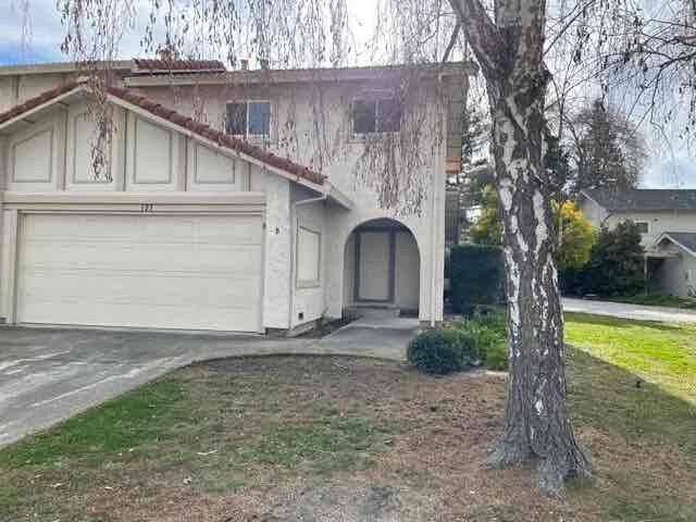
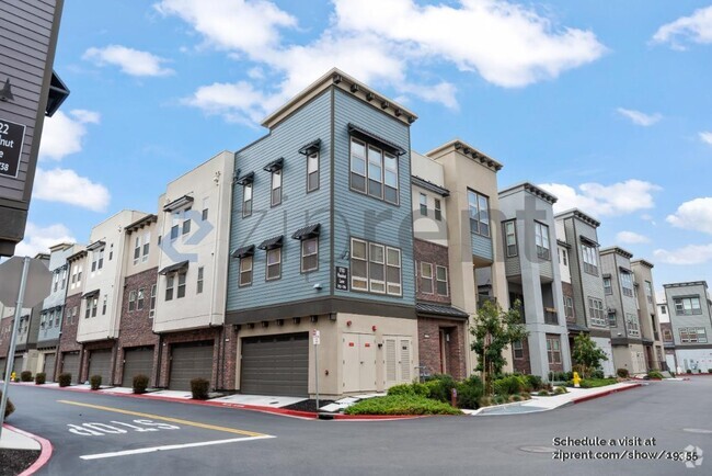
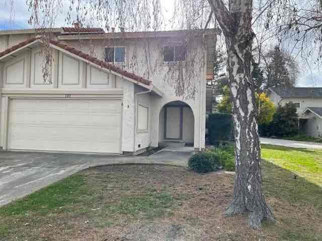
123 Brenton Ct
Mountain View, CA 94043
2 Weeks Ago
Favorites
123 Brenton Ct

Favorites
Check Back Soon for Upcoming Availability
| Beds | Baths | Average SF |
|---|---|---|
| 3 Bedrooms 3 Bedrooms 3 Br | 2.5 Baths 2.5 Baths 2.5 Ba | — |
Fees and Policies
The fees below are based on community-supplied data and may exclude additional fees and utilities.
- Dogs Allowed
-
Fees not specified
- Cats Allowed
-
Fees not specified
- Parking
-
Garage--
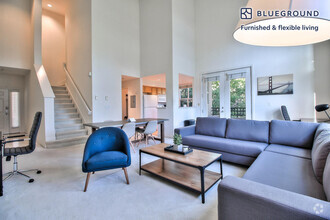
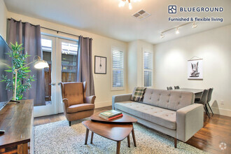
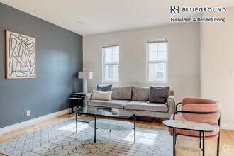
About This Property
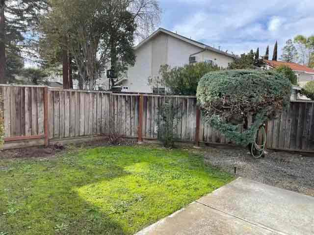
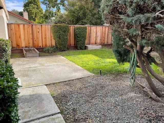
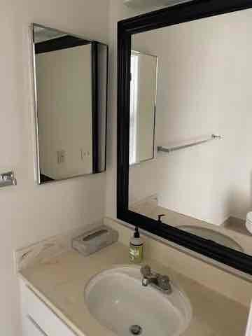
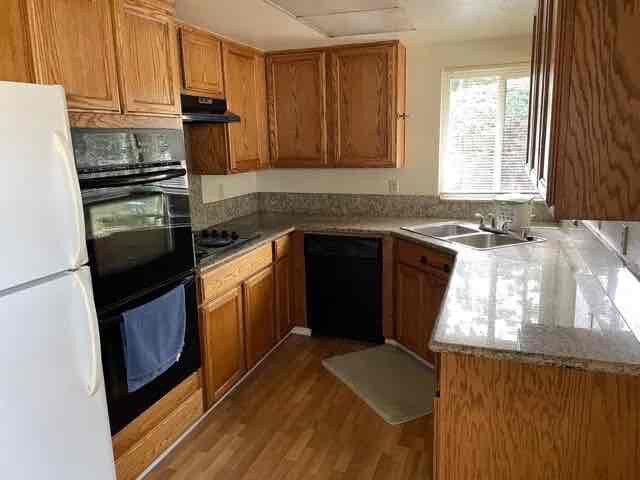
Property Id: 1138298 This lovely duplex home is nestled in a quiet tree-lined neighborhood court, close to local amenities - shopping and food, located near the intersections of freeways 85, 237, 101 and Central Expressway, The Mountain View Whisman station is also very close, for ease of commuting to all areas of the bay area. A quick Google search finds your new home centrally located near the campuses of Google, Microsoft, Linkedin and others. This home comes freshly painted with granite counter tops, new tile flooring in restrooms and new carpeting throughout. Unit comes with a private 2 car garage with ample storage and space and washer/dryer. Entire house has been refreshed and is ready for a new family. The local schools come highly rated in this area and for those outdoor enthusiasts hiking and biking trails at Shoreline and San Antonio park are just a few minutes away. a location rarely available don't miss out on this great opportunity Pet policy - $1,000 per pet deposit.
123 Brenton Ct is a townhome located in Santa Clara County and the 94043 ZIP Code. This area is served by the Mountain View Whisman attendance zone.
Townhome Features
Washer/Dryer
Dishwasher
Refrigerator
Disposal
- Washer/Dryer
- Cable Ready
- Fireplace
- Dishwasher
- Disposal
- Oven
- Refrigerator
- Fenced Lot
- Lawn
Location
Get Directions
Known for its fantastic views of the Santa Cruz Mountains, the Wagon Wheel neighborhood of Mountain View, California lies 12 miles southeast of Palo Alto via US-101S. Residents of Wagon Wheel's apartments and home rentals enjoy convenient transportation via light rail, bus, and private shuttle. Featuring an online chat group, this community values resident participation in planning activities such as ice cream socials, community breakfasts, and pumpkin festivals at the local park.
Two parks serve this neighborhood where residents can picnic, relax in an arbor, or join a pick-up baseball game. Whisman Park provides access to the Stevens Creek Trail, with its paved paths for walking, biking, or jogging through scenic natural areas.
Learn more about living in Wagon WheelBelow are rent ranges for similar nearby apartments
Amenities
- Washer/Dryer
- Cable Ready
- Fireplace
- Dishwasher
- Disposal
- Oven
- Refrigerator
- Fenced Lot
- Lawn
Education
| Colleges & Universities | Distance | ||
|---|---|---|---|
| Colleges & Universities | Distance | ||
| Drive: | 8 min | 3.7 mi | |
| Drive: | 14 min | 5.6 mi | |
| Drive: | 11 min | 6.7 mi | |
| Drive: | 17 min | 7.1 mi |
123 Brenton Ct is within 8 minutes or 3.7 miles from Foothill College, Middlefield. It is also near Foothill Coll., Los Altos and De Anza College.
Schools


Public Elementary School
Grades K-5
367 Students
Nearby
Public Elementary School
Grades K-5
374 Students
Attendance Zone
Public Middle School
Grades 6-8
537 Students
Attendance Zone
Public High School
Grades 9-12
2,220 Students
Attendance Zone
Private Elementary School
Grades PK-6
108 Students
Nearby
Private Elementary, Middle & High School
Grades K-12
597 Students
Nearby
School data provided by
 The GreatSchools Rating helps parents compare schools within a state based on a variety of school quality indicators and provides a helpful picture of how effectively each school serves all of its students. Ratings are on a scale of 1 (below average) to 10 (above average) and can include test scores, college readiness, academic progress, advanced courses, equity, discipline and attendance data. We also advise parents to visit schools, consider other information on school performance and programs, and consider family needs as part of the school selection process.
View GreatSchools Rating Methodology
View GreatSchools Rating Methodology
Transportation options available in Mountain View include Whisman Station, located 0.7 mile from 123 Brenton Ct. 123 Brenton Ct is near Norman Y Mineta San Jose International, located 9.2 miles or 15 minutes away, and San Francisco International, located 25.6 miles or 33 minutes away.
| Transit / Subway | Distance | ||
|---|---|---|---|
| Transit / Subway | Distance | ||
|
|
Walk: | 14 min | 0.7 mi |
|
|
Drive: | 3 min | 1.1 mi |
|
|
Drive: | 3 min | 1.2 mi |
|
Bayshore/Nasa Station
|
Drive: | 4 min | 1.8 mi |
|
|
Drive: | 6 min | 2.6 mi |
| Commuter Rail | Distance | ||
|---|---|---|---|
| Commuter Rail | Distance | ||
| Drive: | 5 min | 2.0 mi | |
| Drive: | 7 min | 2.9 mi | |
| Drive: | 8 min | 3.6 mi | |
| Drive: | 10 min | 4.9 mi | |
| Drive: | 12 min | 5.6 mi |
| Airports | Distance | ||
|---|---|---|---|
| Airports | Distance | ||
|
Norman Y Mineta San Jose International
|
Drive: | 15 min | 9.2 mi |
|
San Francisco International
|
Drive: | 33 min | 25.6 mi |
Time and distance from 123 Brenton Ct.
| Shopping Centers | Distance | ||
|---|---|---|---|
| Shopping Centers | Distance | ||
| Drive: | 3 min | 1.1 mi | |
| Drive: | 4 min | 1.6 mi | |
| Drive: | 4 min | 1.9 mi |
123 Brenton Ct has 3 shopping centers within 1.9 miles, which is about a 4-minute drive. The miles and minutes will be for the farthest away property.
| Parks and Recreation | Distance | ||
|---|---|---|---|
| Parks and Recreation | Distance | ||
|
Stevens Creek Shoreline Nature Study Area
|
Drive: | 9 min | 3.5 mi |
|
J. Pearce Mitchell Park
|
Drive: | 10 min | 4.5 mi |
|
Terman Park
|
Drive: | 11 min | 4.8 mi |
|
Redwood Grove
|
Drive: | 13 min | 5.0 mi |
|
Esther Clark Nature Preserve
|
Drive: | 14 min | 5.8 mi |
123 Brenton Ct has 5 parks within 5.8 miles, including Stevens Creek Shoreline Nature Study Area, J. Pearce Mitchell Park, and Terman Park.
| Hospitals | Distance | ||
|---|---|---|---|
| Hospitals | Distance | ||
| Drive: | 5 min | 2.6 mi | |
| Drive: | 13 min | 7.4 mi | |
| Drive: | 14 min | 7.6 mi |
123 Brenton Ct has 3 hospitals within 7.6 miles, the nearest is El Camino Hospital which is 2.6 miles away and a 5 minute drive.
| Military Bases | Distance | ||
|---|---|---|---|
| Military Bases | Distance | ||
| Drive: | 7 min | 2.6 mi |
123 Brenton Ct is 2.6 miles and a 7 minute drive from Ames Research Center.
You May Also Like
Similar Rentals Nearby


What Are Walk Score®, Transit Score®, and Bike Score® Ratings?
Walk Score® measures the walkability of any address. Transit Score® measures access to public transit. Bike Score® measures the bikeability of any address.
What is a Sound Score Rating?
A Sound Score Rating aggregates noise caused by vehicle traffic, airplane traffic and local sources
123 Brenton Ct
Mountain View, CA 94043