

$3,195 / Month
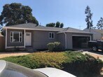
1224 Westwood St
Hayward, CA 94544
2 Weeks Ago
Favorites
1224 Westwood St

Favorites
Check Back Soon for Upcoming Availability
| Beds | Baths | Average SF |
|---|---|---|
| 3 Bedrooms 3 Bedrooms 3 Br | 1 Bath 1 Bath 1 Ba | 1,383 SF |
About This Property
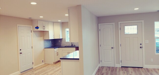
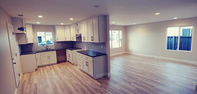
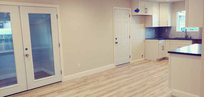
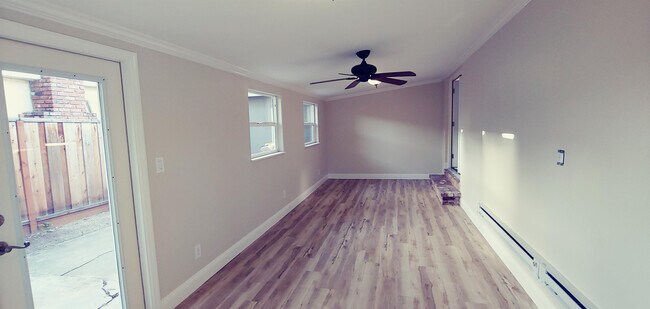
House description- Naturally lit spacious updated home with all new interior. Freshly painted, new laminate flooring, recessed lighting, central heat, and window coverings throughout. Large living room opens to an eat-in kitchen with brand new cabinets, tiled backsplash and fixtures. Stove, refrigerator, hood, and dishwasher included. Sunporch/playroom opens off of the kitchen with tons of natural light and a separate exit to the backyard patio area. Generous bathroom with modern tiled tub/shower enclosure. Bedrooms set back from street at rear of house with view of landscaped backyard Two car garage with built in shelving and laundry hookups.
1224 Westwood St is a house located in Alameda County and the 94544 ZIP Code. This area is served by the Hayward Unified attendance zone.
Location
Get Directions
Harder-Tennyson is a quaint, Bay Area neighborhood in the city of Hayward. The neighborhood is conveniently located along Interstate 880 and is about 10 minutes from the parks and beaches along the San Francisco Bay, such as the Eden Landing Ecological Reserve. Hayward Executive Airport is just a short drive away, as is Southland Mall and sprawling golf courses. Inside the neighborhood, ranch-style houses and green spaces like Weekes Community Center Park make up the area. While residents can easily travel to world-class restaurants in the Bay Area, the neighborhood has a variety of restaurants situated along Tennyson Road. Harder-Tennyson’s rental market is made up of a variety of low-rise apartments as well as a few condos situated along the eastern side of town.
Learn more about living in Harder-TennysonBelow are rent ranges for similar nearby apartments
Education
| Colleges & Universities | Distance | ||
|---|---|---|---|
| Colleges & Universities | Distance | ||
| Drive: | 7 min | 2.7 mi | |
| Drive: | 6 min | 2.8 mi | |
| Drive: | 15 min | 10.6 mi | |
| Drive: | 23 min | 14.7 mi |
1224 Westwood St is within 7 minutes or 2.7 miles from Chabot College. It is also near Cal State East Bay and Ohlone College, Newark.
Schools


Public Elementary School
Grades K-6
301 Students
Attendance Zone
Charter Elementary School
Grades K-5
483 Students
Nearby
Public Middle School
Grades 7-8
711 Students
Attendance Zone
Public High School
Grades 9-12
1,551 Students
Attendance Zone
Private Elementary & Middle School
Grades PK-8
228 Students
Nearby
Private Elementary, Middle & High School
Grades K-12
7 Students
Nearby
Private Elementary School
Grades PK-3
18 Students
Nearby
School data provided by
 The GreatSchools Rating helps parents compare schools within a state based on a variety of school quality indicators and provides a helpful picture of how effectively each school serves all of its students. Ratings are on a scale of 1 (below average) to 10 (above average) and can include test scores, college readiness, academic progress, advanced courses, equity, discipline and attendance data. We also advise parents to visit schools, consider other information on school performance and programs, and consider family needs as part of the school selection process.
View GreatSchools Rating Methodology
Data provided by GreatSchools.org © 2025. All rights reserved.
View GreatSchools Rating Methodology
Data provided by GreatSchools.org © 2025. All rights reserved.
Transportation options available in Hayward include South Hayward, located 2.0 miles from 1224 Westwood St. 1224 Westwood St is near Metro Oakland International, located 12.4 miles or 17 minutes away, and San Francisco International, located 23.0 miles or 30 minutes away.
| Transit / Subway | Distance | ||
|---|---|---|---|
| Transit / Subway | Distance | ||
|
|
Drive: | 5 min | 2.0 mi |
|
|
Drive: | 8 min | 3.3 mi |
|
|
Drive: | 11 min | 5.7 mi |
|
|
Drive: | 13 min | 6.0 mi |
|
|
Drive: | 10 min | 6.3 mi |
| Commuter Rail | Distance | ||
|---|---|---|---|
| Commuter Rail | Distance | ||
| Drive: | 7 min | 4.2 mi | |
|
|
Drive: | 7 min | 4.2 mi |
| Drive: | 13 min | 7.9 mi | |
| Drive: | 27 min | 17.9 mi | |
| Drive: | 28 min | 17.9 mi |
| Airports | Distance | ||
|---|---|---|---|
| Airports | Distance | ||
|
Metro Oakland International
|
Drive: | 17 min | 12.4 mi |
|
San Francisco International
|
Drive: | 30 min | 23.0 mi |
Time and distance from 1224 Westwood St.
| Shopping Centers | Distance | ||
|---|---|---|---|
| Shopping Centers | Distance | ||
| Walk: | 11 min | 0.6 mi | |
| Walk: | 13 min | 0.7 mi | |
| Drive: | 3 min | 1.2 mi |
1224 Westwood St has 3 shopping centers within 1.2 miles, which is about a 3-minute walk. The miles and minutes will be for the farthest away property.
| Parks and Recreation | Distance | ||
|---|---|---|---|
| Parks and Recreation | Distance | ||
|
Sulphur Creek Nature Center
|
Drive: | 11 min | 4.4 mi |
|
Garin/Dry Creek Pioneer Parks
|
Drive: | 10 min | 4.9 mi |
|
Hayward Shoreline Interpretive Center
|
Drive: | 10 min | 5.1 mi |
|
Don Castro Regional Recreation Area
|
Drive: | 11 min | 5.3 mi |
|
Hayward Regional Shoreline
|
Drive: | 16 min | 8.1 mi |
1224 Westwood St has 5 parks within 8.1 miles, including Sulphur Creek Nature Center, Hayward Shoreline Interpretive Center, and Don Castro Regional Recreation Area.
| Hospitals | Distance | ||
|---|---|---|---|
| Hospitals | Distance | ||
| Drive: | 3 min | 1.2 mi | |
| Drive: | 11 min | 7.2 mi | |
| Drive: | 12 min | 8.7 mi |
1224 Westwood St has 3 hospitals within 8.7 miles, the nearest is St. Rose Hospital which is 1.2 miles away and a 3 minute drive.
| Military Bases | Distance | ||
|---|---|---|---|
| Military Bases | Distance | ||
| Drive: | 29 min | 19.8 mi | |
| Drive: | 35 min | 24.0 mi |
1224 Westwood St is 19.8 miles from Alameda/US Naval Air Station Alameda, and is convenient to other military bases, including Ames Research Center.
You May Also Like
Similar Rentals Nearby


What Are Walk Score®, Transit Score®, and Bike Score® Ratings?
Walk Score® measures the walkability of any address. Transit Score® measures access to public transit. Bike Score® measures the bikeability of any address.
What is a Sound Score Rating?
A Sound Score Rating aggregates noise caused by vehicle traffic, airplane traffic and local sources
1224 Westwood St
Hayward, CA 94544