
22023 Violeta Ave
22023 Violeta Ave,
Hawaiian Gardens, CA 90716
$4,630
5 Beds
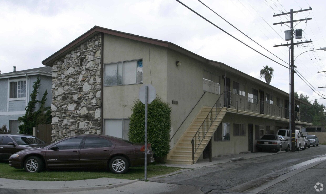

Experience Hawaiian Gardens living at 12147 215th St. The address for this community is at 12147 215th St. in Hawaiian Gardens. Be sure to check out the apartment floorplan options. From availability to location, the leasing staff is ready to help you find the perfect new place. Drop by the leasing office to find out the current pricing.
12147 215th St is an apartment community located in Los Angeles County and the 90716 ZIP Code. This area is served by the ABC Unified attendance zone.
ABC is a lively neighborhood conveniently located 15 miles north of Long Beach and 20 miles south of Los Angeles. The area has a dense population with an abundance of apartments and single-family homes for rent, as well as premier shopping destinations. The Los Cerritos Center, conveniently situated off Interstate 605, attracts shoppers from the surrounding areas. On the other side of town off Highway 91, Cerritos Towne Center provides more retail and dining choices. Quaint boutiques and local eateries are located off Pioneer Boulevard, offering a nice contrast to the large retail centers. More great amenities in town include a few peaceful parks and trails that dot the neighborhood like Liberty Park and Fitness Center.
Learn more about living in ABC| Colleges & Universities | Distance | ||
|---|---|---|---|
| Colleges & Universities | Distance | ||
| Drive: | 7 min | 3.7 mi | |
| Drive: | 8 min | 4.3 mi | |
| Drive: | 10 min | 5.8 mi | |
| Drive: | 10 min | 7.1 mi |


Transportation options available in Hawaiian Gardens include Norwalk, located 6.8 miles from 12147 215th St. 12147 215th St is near Long Beach (Daugherty Field), located 7.2 miles or 13 minutes away, and John Wayne/Orange County, located 19.1 miles or 26 minutes away.
| Transit / Subway | Distance | ||
|---|---|---|---|
| Transit / Subway | Distance | ||
|
|
Drive: | 8 min | 6.8 mi |
|
|
Drive: | 17 min | 8.5 mi |
|
|
Drive: | 12 min | 9.2 mi |
|
|
Drive: | 15 min | 9.2 mi |
|
|
Drive: | 15 min | 9.5 mi |
| Commuter Rail | Distance | ||
|---|---|---|---|
| Commuter Rail | Distance | ||
|
|
Drive: | 13 min | 6.7 mi |
|
|
Drive: | 14 min | 8.1 mi |
|
|
Drive: | 18 min | 11.6 mi |
|
|
Drive: | 21 min | 12.9 mi |
| Drive: | 21 min | 13.0 mi |
| Airports | Distance | ||
|---|---|---|---|
| Airports | Distance | ||
|
Long Beach (Daugherty Field)
|
Drive: | 13 min | 7.2 mi |
|
John Wayne/Orange County
|
Drive: | 26 min | 19.1 mi |
Time and distance from 12147 215th St.
| Shopping Centers | Distance | ||
|---|---|---|---|
| Shopping Centers | Distance | ||
| Walk: | 3 min | 0.2 mi | |
| Walk: | 7 min | 0.4 mi | |
| Walk: | 7 min | 0.4 mi |
| Parks and Recreation | Distance | ||
|---|---|---|---|
| Parks and Recreation | Distance | ||
|
El Dorado Nature Center
|
Drive: | 6 min | 3.4 mi |
|
El Dorado East Regional Park
|
Drive: | 9 min | 4.6 mi |
|
Earl Burns Miller Japanese Garden
|
Drive: | 11 min | 6.4 mi |
|
Colorado Lagoon
|
Drive: | 12 min | 8.0 mi |
|
Los Cerritos Wetlands Trust
|
Drive: | 12 min | 8.2 mi |
| Hospitals | Distance | ||
|---|---|---|---|
| Hospitals | Distance | ||
| Drive: | 5 min | 2.6 mi | |
| Drive: | 5 min | 3.0 mi | |
| Drive: | 8 min | 5.5 mi |
| Military Bases | Distance | ||
|---|---|---|---|
| Military Bases | Distance | ||
| Drive: | 12 min | 6.3 mi | |
| Drive: | 33 min | 17.2 mi |
What Are Walk Score®, Transit Score®, and Bike Score® Ratings?
Walk Score® measures the walkability of any address. Transit Score® measures access to public transit. Bike Score® measures the bikeability of any address.
What is a Sound Score Rating?
A Sound Score Rating aggregates noise caused by vehicle traffic, airplane traffic and local sources

12147 215th St
Hawaiian Gardens, CA 90716


 - Violet on Virgil")