
$2,400
/ Month
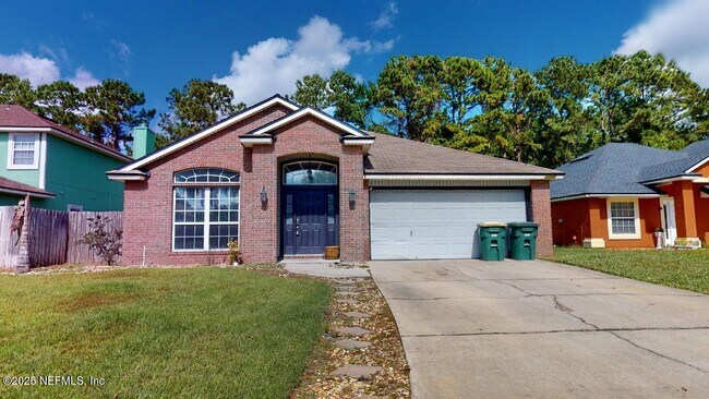
12107 Livery Dr
Jacksonville, FL 32246
1 Day Ago
Favorites
904-551-7903
-
Bedrooms
4
-
Bathrooms
2
-
Square Feet
1,922 sq ft
-
Available
Available Now
Highlights
- Open Floorplan
- Traditional Architecture
- 1 Fireplace
- Split Bedroom Floorplan
- Porch
- Walk-In Closet
12107 Livery Dr

Favorites
Matterport 3D Tour
About This Home
$2,400 deposit,
Available Now
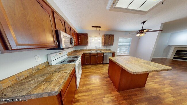
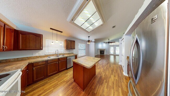
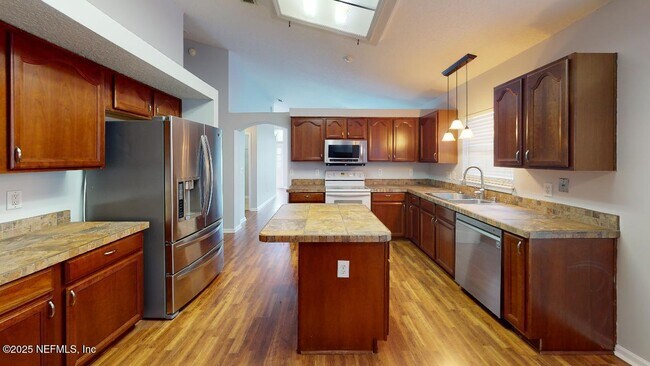
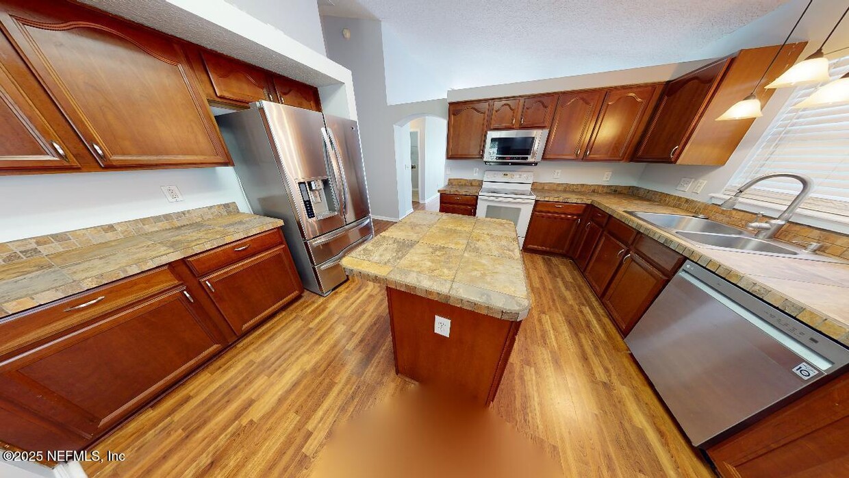
Beautiful 4 bedroom,2 bathrooms. Gorgeous 4 bedrooms 2 bathrooms 1922 SqFt home . Split bedrooms,Great floor plan .Very spacious Livingroom. Kitchen with a lot of cabinets,cooking island and stainless steel appliances . Hardwood floors throughout the common areas and new carpet in the bedrooms only . Large master bedroom with walking closet and spacious bathroom with separate shower and tub. Large size back yard with pergola and fire pit for relaxing evenings.
12107 Livery Dr is a house located in Duval County and the 32246 ZIP Code. This area is served by the Duval County Public Schools attendance zone.
* Price shown is base rent. Excludes user-selected optional fees and variable or usage-based fees and required charges due at or prior to move-in or at move-out. Price, availability, fees, and any applicable rent special are subject to change without notice.
* Square footage definitions vary. Displayed square footage is approximate.
Home Details
Home Type
Single Family Detached Home
Year Built
Built in 2003
Bedrooms and Bathrooms
Split Bedroom Floorplan
Walk-In Closet
2 Full Bathrooms
4 Bedrooms
Bathtub With Separate Shower Stall
Home Design
Traditional Architecture
Interior Spaces
Open Floorplan
1 Fireplace
Ceiling Fan
1,922 Sq Ft Home
1-Story Property
Kitchen
Electric Range
Ice Maker
Microwave
Dishwasher
Disposal
Laundry
Washer and Electric Dryer Hookup
Listing and Financial Details
12 Months Lease Term
Assessor Parcel Number 1652863320
Tenant pays for all utilities
Lot Details
8,276 Sq Ft Lot
Property is Fully Fenced
Outdoor Features
Porch
Fire Pit
Parking
2 Car Garage
Utilities
Cooling Available
Heating Available
Community Details
Overview
No Home Owners Association
Coachman Meadows Subdivision
Pet Policy
No Pets Allowed
Contact
- Listed by VIOLETA STAYKOVA | VS REALTY
- Phone Number
- Contact
-
Source
Northeast Florida Multiple Listing Service, Inc.
Copyright 2025 realMLS. All rights reserved. Information is deemed reliable but not guaranteed.
Location
Get Directions
Development on the Sandalwood neighborhood began in the spring of 1960. Designed to provide inhabitants with the ideal balance of work and play, Sandalwood sits approximately half way between Jacksonville city center and its nearest beach, which lies roughly six miles east of the neighborhood.
Developer Pearce-Uible's primary Sandalwood concept contained 500 houses. To give the neighborhood an exotic ambiance, Sandalwood's original streets were all named after Pacific Islands. Mindanao Drive, Hawaii Drive East, and Kusai Drive are three of those original roadways. Two more streets, Majuro Drive and Luana Drive, were added to the neighborhood in 1969.
Nearly half the houses in the modern Sandalwood neighborhood are quite new. The original 1960s properties reside in the northern half of the area, whereas newer houses extend to the southern part of the neighborhood. Several educational establishments call the area home, including Sandalwood High School, established in 1971.
Learn more about living in Sandalwood
Education
| Colleges & Universities | Distance | ||
|---|---|---|---|
| Colleges & Universities | Distance | ||
| Drive: | 10 min | 3.4 mi | |
| Drive: | 20 min | 9.4 mi | |
| Drive: | 23 min | 11.1 mi | |
| Drive: | 22 min | 11.8 mi |
12107 Livery Dr is within 10 minutes or 3.4 miles from University of North Florida. It is also near Jacksonville University and Florida Coastal School of Law.
Schools


Public Elementary School
Grades K-5
646 Students
Attendance Zone
Public Middle School
Grades 6-8
1,136 Students
Attendance Zone
Public High School
Grades 9-12
2,771 Students
Attendance Zone
Private Elementary, Middle & High School
Grades PK-11
254 Students
Nearby
Private Elementary, Middle & High School
Grades PK-12
221 Students
Nearby
School data provided by
 The GreatSchools Rating helps parents compare schools within a state based on a variety of school quality indicators and provides a helpful picture of how effectively each school serves all of its students. Ratings are on a scale of 1 (below average) to 10 (above average) and can include test scores, college readiness, academic progress, advanced courses, equity, discipline and attendance data. We also advise parents to visit schools, consider other information on school performance and programs, and consider family needs as part of the school selection process.
View GreatSchools Rating Methodology
Data provided by GreatSchools.org © 2025. All rights reserved.
View GreatSchools Rating Methodology
Data provided by GreatSchools.org © 2025. All rights reserved.
Transportation options available in Jacksonville include Rosa L. Parks/Fccj, located 10.8 miles from 12107 Livery Dr. 12107 Livery Dr is near Jacksonville International, located 20.6 miles or 34 minutes away.
| Transit / Subway | Distance | ||
|---|---|---|---|
| Transit / Subway | Distance | ||
|
|
Drive: | 22 min | 10.8 mi |
| Drive: | 23 min | 11.3 mi | |
|
|
Drive: | 23 min | 11.5 mi |
|
|
Drive: | 23 min | 11.7 mi |
|
|
Drive: | 24 min | 11.9 mi |
| Commuter Rail | Distance | ||
|---|---|---|---|
| Commuter Rail | Distance | ||
|
|
Drive: | 31 min | 16.7 mi |
| Airports | Distance | ||
|---|---|---|---|
| Airports | Distance | ||
|
Jacksonville International
|
Drive: | 34 min | 20.6 mi |
Time and distance from 12107 Livery Dr.
| Shopping Centers | Distance | ||
|---|---|---|---|
| Shopping Centers | Distance | ||
| Drive: | 5 min | 1.7 mi | |
| Drive: | 5 min | 2.0 mi | |
| Drive: | 8 min | 2.6 mi |
12107 Livery Dr has 3 shopping centers within 2.6 miles, which is about a 8-minute drive. The miles and minutes will be for the farthest away property.
| Parks and Recreation | Distance | ||
|---|---|---|---|
| Parks and Recreation | Distance | ||
|
Beach and Peach Park
|
Drive: | 11 min | 4.8 mi |
|
Touchton Road Park
|
Drive: | 13 min | 6.0 mi |
|
Ed Austin Regional Park
|
Drive: | 14 min | 6.1 mi |
|
Jacksonville Arboretum and Gardens
|
Drive: | 13 min | 6.4 mi |
|
Castaway Island Preserve
|
Drive: | 15 min | 6.9 mi |
12107 Livery Dr has 5 parks within 6.9 miles, including Beach and Peach Park, Jacksonville Arboretum and Gardens, and Touchton Road Park.
| Hospitals | Distance | ||
|---|---|---|---|
| Hospitals | Distance | ||
| Drive: | 14 min | 7.0 mi | |
| Drive: | 15 min | 7.4 mi | |
| Drive: | 16 min | 7.7 mi |
12107 Livery Dr has 3 hospitals within 7.7 miles, the nearest is River Point Behavioral Health which is 7.0 miles away and a 14 minute drive.
| Military Bases | Distance | ||
|---|---|---|---|
| Military Bases | Distance | ||
| Drive: | 23 min | 11.5 mi | |
| Drive: | 37 min | 25.7 mi |
12107 Livery Dr is 11.5 miles from Mayport Naval Air Station, and is convenient to other military bases, including Jacksonville Naval Air Station.
You May Also Like
Similar Rentals Nearby


What Are Walk Score®, Transit Score®, and Bike Score® Ratings?
Walk Score® measures the walkability of any address. Transit Score® measures access to public transit. Bike Score® measures the bikeability of any address.
What is a Sound Score Rating?
A Sound Score Rating aggregates noise caused by vehicle traffic, airplane traffic and local sources
12107 Livery Dr
Jacksonville, FL 32246