$5,750
Total Monthly Price
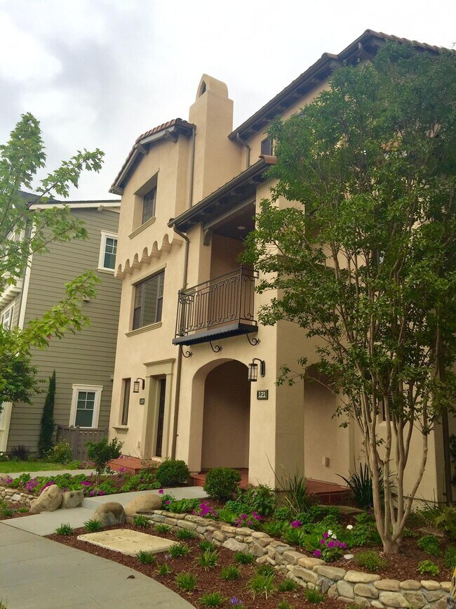
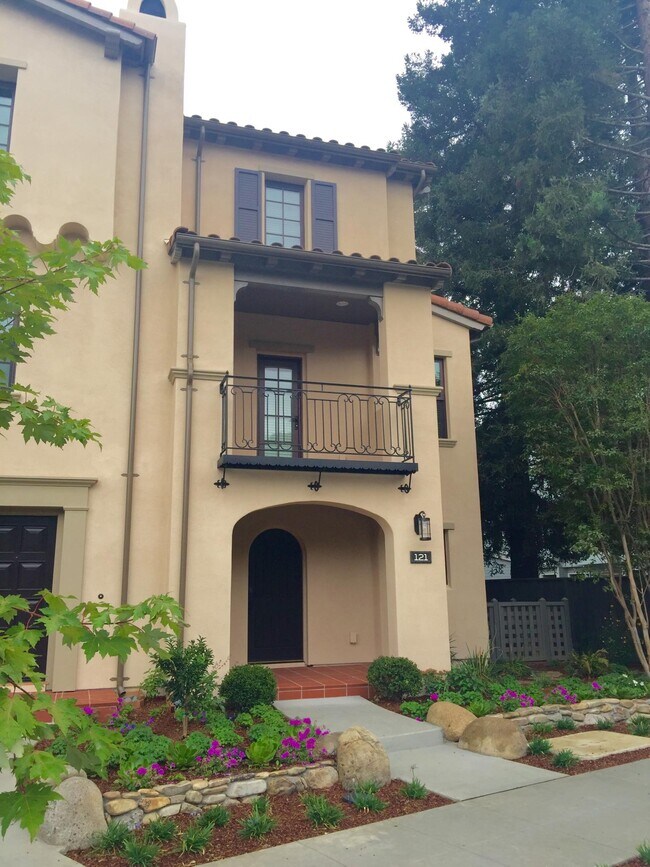
121 Easy St
Mountain View, CA 94043
Favorites
121 Easy St

Favorites
Check Back Soon for Upcoming Availability
| Beds | Baths | Average SF |
|---|---|---|
| 3 Bedrooms 3 Bedrooms 3 Br | 3.5 Baths 3.5 Baths 3.5 Ba | 1,593 SF |
Fees and Policies
The fees listed below are community-provided and may exclude utilities or add-ons. All payments are made directly to the property and are non-refundable unless otherwise specified.
- Dogs Allowed
-
Fees not specified
- Cats Allowed
-
Fees not specified
- Parking
-
Garage--
About This Property
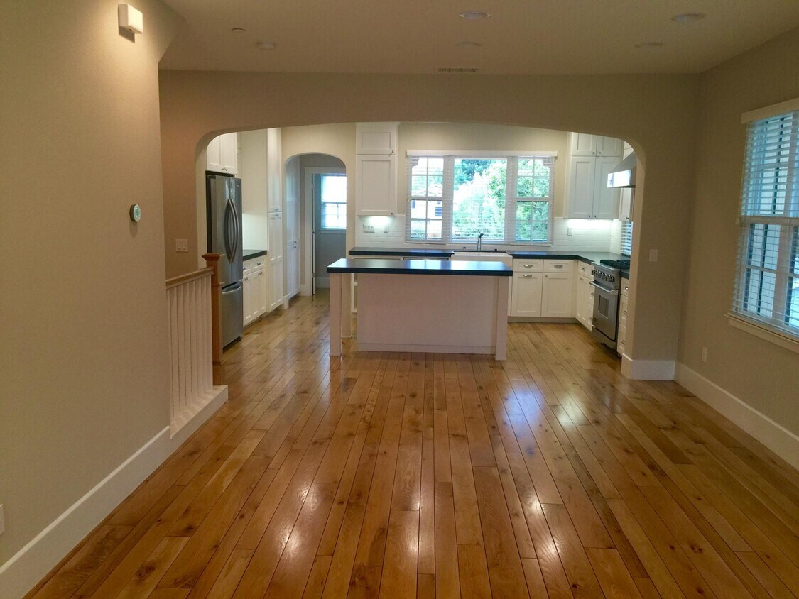
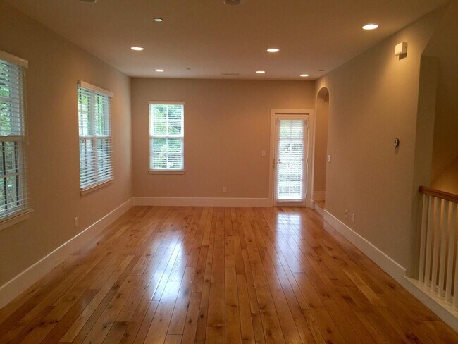
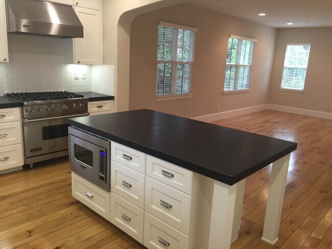
COMING SOON! Charming, light-filled corner townhouse with spacious floor plan. Finely crafted high –end features and finishes including: hardwood floors, granite counters, upgraded stainless steel appliances (6 burner gas stove). Spacious 2-car garage, three bedrooms with en-suite bathrooms, ample storage, and a full size washer/dryer. Only a short 1-1.5 mile walk to all your favorite Downtown Mountain View spots + access to the highly desirable Mountain View school district! Located in the quaint neighborhood of Apricot Commons built by Robson Homes where bungalow architecture reflects the historic character of the town, including a mix of arts and crafts Spanish style homes. Enjoy a morning stroll through a lush courtyard in the middle of the neighborhood or a day out exploring Downtown Mountain View.
121 Easy St is a townhome located in Santa Clara County and the 94043 ZIP Code.
Townhome Features
Washer/Dryer
Air Conditioning
Dishwasher
Hardwood Floors
- Washer/Dryer
- Air Conditioning
- Smoke Free
- Dishwasher
- Stainless Steel Appliances
- Hardwood Floors
- Courtyard
121 Easy St,
Mountain View,
CA
94043
Known for its fantastic views of the Santa Cruz Mountains, the Wagon Wheel neighborhood of Mountain View, California lies 12 miles southeast of Palo Alto via US-101S. Residents of Wagon Wheel's apartments and home rentals enjoy convenient transportation via light rail, bus, and private shuttle. Featuring an online chat group, this community values resident participation in planning activities such as ice cream socials, community breakfasts, and pumpkin festivals at the local park.
Two parks serve this neighborhood where residents can picnic, relax in an arbor, or join a pick-up baseball game. Whisman Park provides access to the Stevens Creek Trail, with its paved paths for walking, biking, or jogging through scenic natural areas.
Learn more about living in Wagon WheelBelow are rent ranges for similar nearby apartments
Amenities
- Washer/Dryer
- Air Conditioning
- Smoke Free
- Dishwasher
- Stainless Steel Appliances
- Hardwood Floors
- Courtyard
Education
| Colleges & Universities | Distance | ||
|---|---|---|---|
| Colleges & Universities | Distance | ||
| Drive: | 7 min | 3.4 mi | |
| Drive: | 14 min | 5.7 mi | |
| Drive: | 16 min | 6.9 mi | |
| Drive: | 12 min | 7.4 mi |
121 Easy St is within 7 minutes or 3.4 miles from Foothill College, Middlefield. It is also near Foothill Coll., Los Altos and De Anza College.
Transportation options available in Mountain View include Whisman Station, located 0.8 mile from 121 Easy St. 121 Easy St is near Norman Y Mineta San Jose International, located 9.6 miles or 14 minutes away, and San Francisco International, located 25.3 miles or 32 minutes away.
| Transit / Subway | Distance | ||
|---|---|---|---|
| Transit / Subway | Distance | ||
|
|
Walk: | 16 min | 0.8 mi |
| Walk: | 23 min | 1.2 mi | |
|
|
Drive: | 4 min | 1.4 mi |
| Drive: | 4 min | 2.1 mi | |
| Drive: | 6 min | 3.0 mi |
| Commuter Rail | Distance | ||
|---|---|---|---|
| Commuter Rail | Distance | ||
| Drive: | 5 min | 2.0 mi | |
| Drive: | 8 min | 3.0 mi | |
| Drive: | 7 min | 3.1 mi | |
| Drive: | 12 min | 5.7 mi | |
| Drive: | 10 min | 6.5 mi |
| Airports | Distance | ||
|---|---|---|---|
| Airports | Distance | ||
|
Norman Y Mineta San Jose International
|
Drive: | 14 min | 9.6 mi |
|
San Francisco International
|
Drive: | 32 min | 25.3 mi |
Walkability Near 121 Easy St Mountain View, CA 94043
Getting Around
 What do Walkability, Transit, Drivability, and Bikeability mean?
Walkability measures the walking distance to day-to-day needs.
Transit measures access to public transportation.
Drivability measures congestion, parking availability, and access to major roads.
Bikeability measures the suitability for cycling.
How It Works
What do Walkability, Transit, Drivability, and Bikeability mean?
Walkability measures the walking distance to day-to-day needs.
Transit measures access to public transportation.
Drivability measures congestion, parking availability, and access to major roads.
Bikeability measures the suitability for cycling.
How It Works
Fairly Walkable
Walkability
40
/ 100
Some Public Transit
Transit
50
/ 100
Exceptionally Drivable
Drivability
100
/ 100
Very Bikeable
Bikeability
80
/ 100
Scores provided by
-
Soundscore™
-
/ 100
Traffic
-Airport
-Businesses
-Scores provided by
HowLoud What is a Sound Score Rating? A Sound Score Rating aggregates noise caused by vehicle traffic, airplane traffic and local sources. How It WorksTime and distance from 121 Easy St.
| Shopping Centers | Distance | ||
|---|---|---|---|
| Shopping Centers | Distance | ||
| Walk: | 20 min | 1.1 mi | |
| Drive: | 4 min | 1.5 mi | |
| Drive: | 5 min | 2.1 mi |
121 Easy St has 3 shopping centers within 2.1 miles, which is about a 5-minute drive. The miles and minutes will be for the farthest away property.
| Parks and Recreation | Distance | ||
|---|---|---|---|
| Parks and Recreation | Distance | ||
|
Stevens Creek Shoreline Nature Study Area
|
Drive: | 8 min | 3.2 mi |
|
J. Pearce Mitchell Park
|
Drive: | 10 min | 4.2 mi |
|
Terman Park
|
Drive: | 10 min | 4.6 mi |
|
Redwood Grove
|
Drive: | 13 min | 5.8 mi |
|
Foothill College Observatory
|
Drive: | 15 min | 5.9 mi |
121 Easy St has 5 parks within 5.9 miles, including Stevens Creek Shoreline Nature Study Area, J. Pearce Mitchell Park, and Terman Park.
| Hospitals | Distance | ||
|---|---|---|---|
| Hospitals | Distance | ||
| Drive: | 6 min | 2.8 mi | |
| Drive: | 13 min | 8.8 mi | |
| Drive: | 14 min | 9.0 mi |
121 Easy St has 3 hospitals within 9.0 miles, the nearest is El Camino Hospital which is 2.8 miles away and a 6 minute drive.
| Military Bases | Distance | ||
|---|---|---|---|
| Military Bases | Distance | ||
| Drive: | 7 min | 2.3 mi | |
| Drive: | 56 min | 41.5 mi | |
| Drive: | 57 min | 41.7 mi |
121 Easy St has 3 military bases within 41.7 miles, the nearest is Ames Research Center which is 2.3 miles away and a 7 minute drive.
You May Also Like
Similar Rentals Nearby
-
-
-
-
-
-
 3 Beds$5,990Total Monthly PriceTotal Monthly Price NewPrices include all required monthly fees.Townhome for Rent
 -
 3 Beds$5,820Total Monthly PriceTotal Monthly Price NewPrices include all required monthly fees.Townhome for Rent
 -
 3 Beds$4,990Total Monthly PriceTotal Monthly Price NewPrices include all required monthly fees.Townhome for Rent
 -
 3 Beds$3,480Total Monthly PriceTotal Monthly Price NewPrices include all required monthly fees.Townhome for Rent
 -
 3 Beds$3,820Total Monthly PriceTotal Monthly Price NewPrices include all required monthly fees.Townhome for Rent


What Are Walk Score®, Transit Score®, and Bike Score® Ratings?
Walk Score® measures the walkability of any address. Transit Score® measures access to public transit. Bike Score® measures the bikeability of any address.
What is a Sound Score Rating?
A Sound Score Rating aggregates noise caused by vehicle traffic, airplane traffic and local sources.

121 Easy St
Mountain View, CA 94043