
$2,800
/ Month
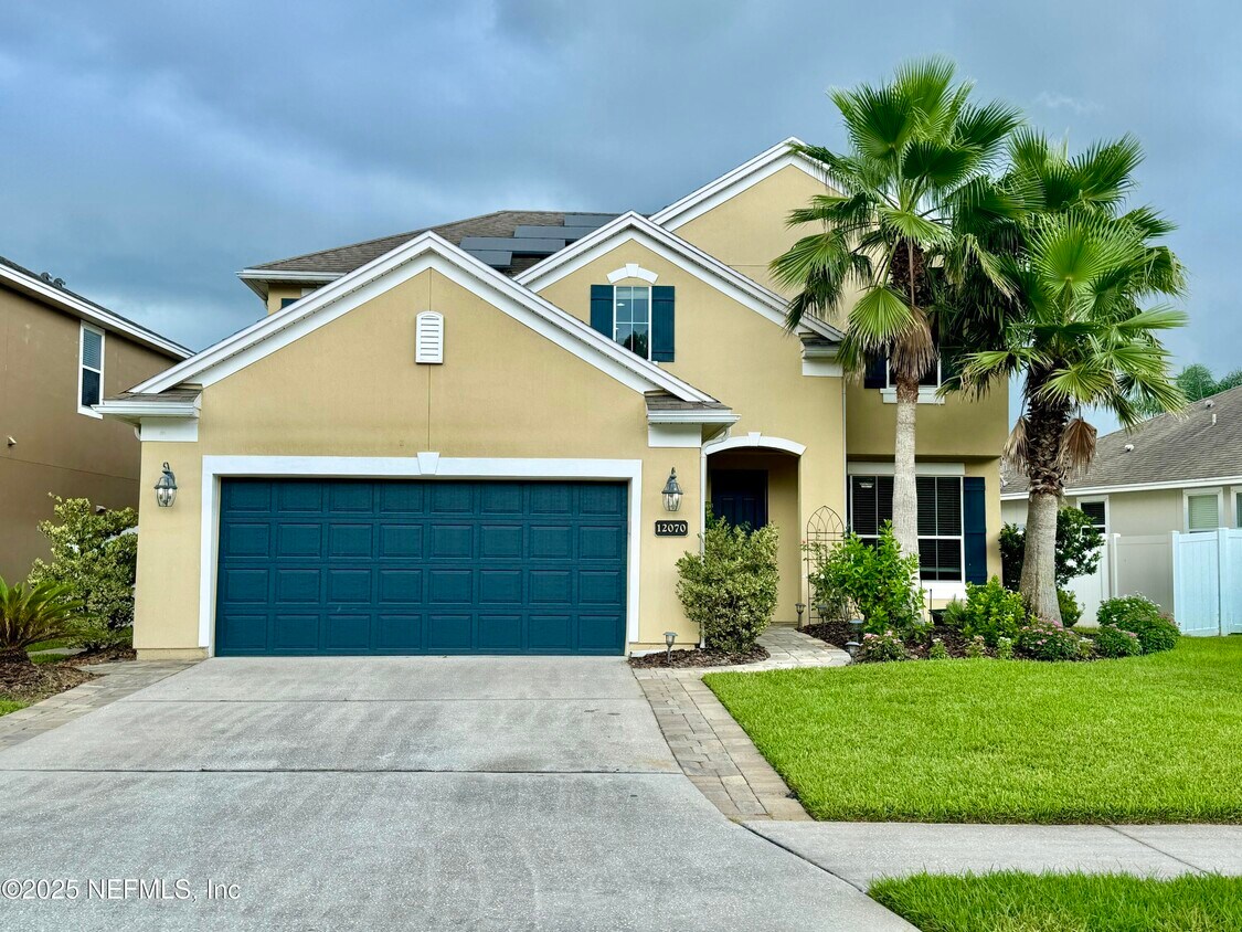
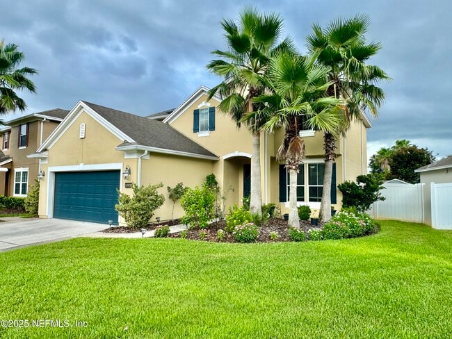
12070 Wynnfield Lakes Cir
Jacksonville, FL 32246
Today
|
Edit
Favorites
904-900-4766
-
Bedrooms
4
-
Bathrooms
2.5
-
Square Feet
2,252 sq ft
-
Available
Available Nov 8
12070 Wynnfield Lakes Cir

Favorites
About This Home
$2,800 deposit,
Available Nov 8
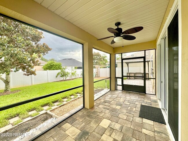
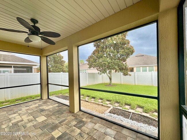
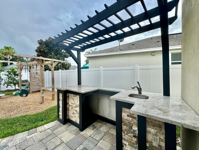
his impressive 4-bedroom,2.5-bathroom,two-story home is located in the highly sought-after Wynnfield Lakes community. The spacious layout includes a large screened patio,perfect for outdoor dining and relaxation,complete with an outdoor kitchen area ready for your bbq grill for added convenience. The backyard features a playground,making it a fun space for all ages. Centrally located,this property is just a short drive from Jacksonville Beach,St. Johns Town Center,and NS Mayport,offering easy access to shopping,dining,and the coast. APPROVED PETS WELCOMED!!! MLS# 2116275
12070 Wynnfield Lakes Cir is a house located in Duval County and the 32246 ZIP Code.
* Price shown is base rent. Excludes user-selected optional fees and variable or usage-based fees and required charges due at or prior to move-in or at move-out. Price, availability, fees, and any applicable rent special are subject to change without notice.
* Square footage definitions vary. Displayed square footage is approximate.
Fees and Policies
The fees below are based on community-supplied data and may exclude additional fees and utilities.
- One-Time Basics
- Due at Application
- Application Fee Per Applicant$75
- Due at Move-In
- Security Deposit - Refundable$2,800
- Due at Application
Property Fee Disclaimer: Based on community-supplied data and independent market research. Subject to change without notice. May exclude fees for mandatory or optional services and usage-based utilities.
Contact
- Listed by JENNIFER BRAY | Navy to Navy Homes LLC
- Phone Number
- Contact
-
Source
Northeast Florida Multiple Listing Service, Inc.
Copyright 2025 realMLS. All rights reserved. Information is deemed reliable but not guaranteed.
Location
Get Directions
Development on the Sandalwood neighborhood began in the spring of 1960. Designed to provide inhabitants with the ideal balance of work and play, Sandalwood sits approximately half way between Jacksonville city center and its nearest beach, which lies roughly six miles east of the neighborhood.
Developer Pearce-Uible's primary Sandalwood concept contained 500 houses. To give the neighborhood an exotic ambiance, Sandalwood's original streets were all named after Pacific Islands. Mindanao Drive, Hawaii Drive East, and Kusai Drive are three of those original roadways. Two more streets, Majuro Drive and Luana Drive, were added to the neighborhood in 1969.
Nearly half the houses in the modern Sandalwood neighborhood are quite new. The original 1960s properties reside in the northern half of the area, whereas newer houses extend to the southern part of the neighborhood. Several educational establishments call the area home, including Sandalwood High School, established in 1971.
Learn more about living in Sandalwood
Education
| Colleges & Universities | Distance | ||
|---|---|---|---|
| Colleges & Universities | Distance | ||
| Drive: | 10 min | 5.0 mi | |
| Drive: | 21 min | 9.8 mi | |
| Drive: | 24 min | 11.5 mi | |
| Drive: | 24 min | 12.9 mi |
12070 Wynnfield Lakes Cir is within 10 minutes or 5.0 miles from University of North Florida. It is also near Jacksonville University and Fla. State Coll. Jacksonville.
Transportation options available in Jacksonville include Rosa L. Parks/Fccj, located 11.2 miles from 12070 Wynnfield Lakes Cir. 12070 Wynnfield Lakes Cir is near Jacksonville International, located 21.0 miles or 34 minutes away.
| Transit / Subway | Distance | ||
|---|---|---|---|
| Transit / Subway | Distance | ||
|
|
Drive: | 22 min | 11.2 mi |
| Drive: | 25 min | 11.4 mi | |
|
|
Drive: | 26 min | 11.6 mi |
|
|
Drive: | 25 min | 11.8 mi |
|
|
Drive: | 26 min | 12.3 mi |
| Commuter Rail | Distance | ||
|---|---|---|---|
| Commuter Rail | Distance | ||
|
|
Drive: | 32 min | 17.1 mi |
| Airports | Distance | ||
|---|---|---|---|
| Airports | Distance | ||
|
Jacksonville International
|
Drive: | 34 min | 21.0 mi |
Time and distance from 12070 Wynnfield Lakes Cir.
| Shopping Centers | Distance | ||
|---|---|---|---|
| Shopping Centers | Distance | ||
| Walk: | 19 min | 1.0 mi | |
| Drive: | 5 min | 1.1 mi | |
| Drive: | 6 min | 1.3 mi |
12070 Wynnfield Lakes Cir has 3 shopping centers within 1.3 miles, which is about a 6-minute walk. The miles and minutes will be for the farthest away property.
| Parks and Recreation | Distance | ||
|---|---|---|---|
| Parks and Recreation | Distance | ||
|
Castaway Island Preserve
|
Drive: | 11 min | 4.7 mi |
|
Ed Austin Regional Park
|
Drive: | 11 min | 5.0 mi |
|
Beach and Peach Park
|
Drive: | 14 min | 6.4 mi |
|
Jacksonville Arboretum and Gardens
|
Drive: | 14 min | 6.8 mi |
|
Touchton Road Park
|
Drive: | 16 min | 7.6 mi |
12070 Wynnfield Lakes Cir has 5 parks within 7.6 miles, including Castaway Island Preserve, Ed Austin Regional Park, and Jacksonville Arboretum and Gardens.
| Hospitals | Distance | ||
|---|---|---|---|
| Hospitals | Distance | ||
| Drive: | 15 min | 7.1 mi | |
| Drive: | 18 min | 8.7 mi | |
| Drive: | 19 min | 8.9 mi |
12070 Wynnfield Lakes Cir has 3 hospitals within 8.9 miles, the nearest is Mayo Clinic Florida which is 7.1 miles away and a 15 minute drive.
| Military Bases | Distance | ||
|---|---|---|---|
| Military Bases | Distance | ||
| Drive: | 19 min | 9.9 mi | |
| Drive: | 40 min | 27.3 mi |
12070 Wynnfield Lakes Cir is 9.9 miles from Mayport Naval Air Station, and is convenient to other military bases, including Jacksonville Naval Air Station.
You May Also Like
Similar Rentals Nearby


What Are Walk Score®, Transit Score®, and Bike Score® Ratings?
Walk Score® measures the walkability of any address. Transit Score® measures access to public transit. Bike Score® measures the bikeability of any address.
What is a Sound Score Rating?
A Sound Score Rating aggregates noise caused by vehicle traffic, airplane traffic and local sources

12070 Wynnfield Lakes Cir
Jacksonville, FL 32246