
$2,795 / Month
12 Day St
San Francisco, CA 94110
2 Weeks Ago
Favorites
12 Day St

Favorites
Check Back Soon for Upcoming Availability
| Beds | Baths | Average SF |
|---|---|---|
| 2 Bedrooms 2 Bedrooms 2 Br | 1 Bath 1 Bath 1 Ba | — |
About This Property
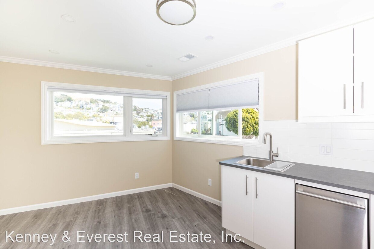
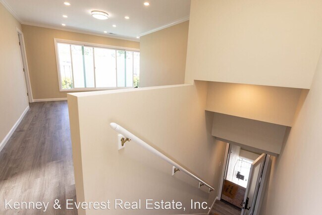
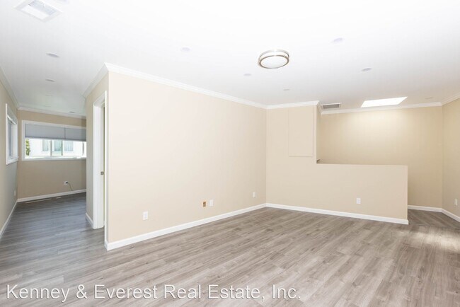
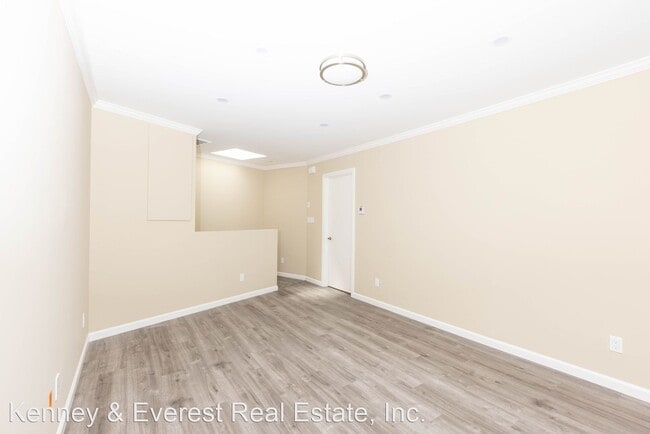
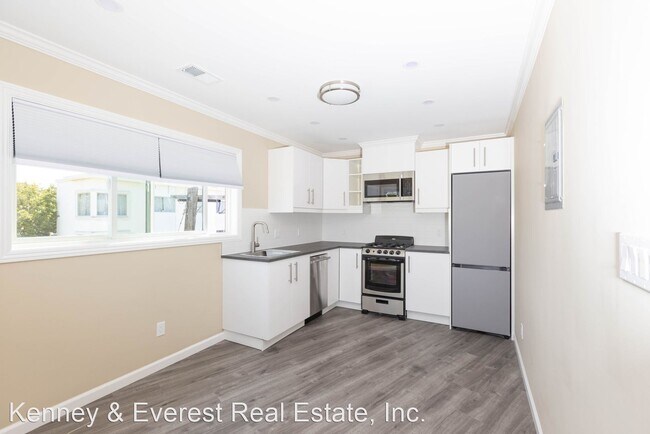
- OPEN HOUSE SUNDAY 7/31 12:45-1:15 PM Gorgeous Top Floor 2BR/1BA, Gorgeous Panoramic Views, On-Site Laundry, Shared Backyard (12 Day Street) - Large Top, 2nd Floor 2BR/1BA Apartment * $2,795/month annual lease * Panoramic view * On-site laundry * Skylights * Backyard w/BBQ area * Available: Now Open House: SUNDAY 7/31 12:45-1:15PM ADDRESS: 12 Day Street An amazing opportunity to live in this centrally located and newly remodeled Bernal Heights apartment! Views of the city, from this super light and sunny, top floor, Bernal Heights remodeled two bedroom. Two large closets in the primary bedroom and large closet in the secondary bedroom. Large bathroom with double sink and walk-in shower. With an oversized open living and dining room (southern exposure), newly remodeled eat-in kitchen with new appliances and views, washer dryer on-site, skylights and recessed lighting throughout. There is a beautiful backyard with a BBQ and more than enough room to entertain. A very rare offering if you want a bright apartment across the street from Safeway and steps away from SF's famous, Mitchell's Ice Cream Building is located on the corner of Day Street and San Jose Avenue. Bernal Heights dining and shopping are two blocks away. Walk Score is 98. Transit Score is 75. Bike score 83. 1 block from the J Church metro stop. Tenant pays a one-time broker's fee. Everest Mwamba DRE# 01717299 Kenney & Everest Real Estate DRE# 01984640 office Apply at: Leasing and Real Estate: Our Family Business for Over 100 Years. This unit is a rental unit subject to the San Francisco Rent Ordinance, which limits evictions without just cause, and which states that any waiver by a tenant of their rights under the Rent Ordinance is void as contrary to public policy. (RLNE7453470)
12 Day St is a house located in San Francisco County and the 94110 ZIP Code. This area is served by the San Francisco Unified attendance zone.
Location
Get Directions
Noe Valley is in central San Francisco, encompassed by modern comforts. Many renters choose Noe Valley apartments because of the convenient access to city transit. The SFMTA Light Rails pick up along Church Street, and BART 24th Street Mission Station is a short walk away.
Most of the neighborhood’s bars, eateries, and bakeries are found along 24th Street. A couple of green spaces are in Noe Valley, such as Upper Noe Recreation Center and Noe Valley Courts. Residents enjoy hiking along the trails at nearby Twin Peaks and perusing the luxury jewelry shops and boutiques in town3.
Learn more about living in Noe ValleyBelow are rent ranges for similar nearby apartments
Education
| Colleges & Universities | Distance | ||
|---|---|---|---|
| Colleges & Universities | Distance | ||
| Drive: | 5 min | 2.5 mi | |
| Drive: | 11 min | 3.9 mi | |
| Drive: | 8 min | 5.5 mi | |
| Drive: | 9 min | 5.9 mi |
12 Day St is within 5 minutes or 2.5 miles from City College of San Francisco. It is also near California College of the Arts and UC San Francisco, Mission Bay.
Schools

Public Elementary School
Grades K-5
Nearby
Public Elementary School
Grades K-5
308 Students
Attendance Zone
Public Middle & High School
Grades 8-12
401 Students
Nearby
Public Middle School
Grades 6-8
485 Students
Attendance Zone
Private Elementary & Middle School
Grades PK-8
476 Students
Nearby
Private Elementary & Middle School
Grades K-8
Nearby
Private High School
Grades 9-12
364 Students
Nearby
School data provided by
 The GreatSchools Rating helps parents compare schools within a state based on a variety of school quality indicators and provides a helpful picture of how effectively each school serves all of its students. Ratings are on a scale of 1 (below average) to 10 (above average) and can include test scores, college readiness, academic progress, advanced courses, equity, discipline and attendance data. We also advise parents to visit schools, consider other information on school performance and programs, and consider family needs as part of the school selection process.
View GreatSchools Rating Methodology
Data provided by GreatSchools.org © 2025. All rights reserved.
View GreatSchools Rating Methodology
Data provided by GreatSchools.org © 2025. All rights reserved.
Transportation options available in San Francisco include 30Th Street And Dolores, located 0.1 mile from 12 Day St. 12 Day St is near San Francisco International, located 12.6 miles or 19 minutes away, and Metro Oakland International, located 23.0 miles or 37 minutes away.
| Transit / Subway | Distance | ||
|---|---|---|---|
| Transit / Subway | Distance | ||
|
|
Walk: | 2 min | 0.1 mi |
|
|
Walk: | 4 min | 0.2 mi |
|
|
Walk: | 5 min | 0.3 mi |
|
|
Walk: | 5 min | 0.3 mi |
| Walk: | 7 min | 0.4 mi |
| Commuter Rail | Distance | ||
|---|---|---|---|
| Commuter Rail | Distance | ||
| Drive: | 8 min | 4.7 mi | |
| Drive: | 8 min | 5.7 mi | |
| Drive: | 8 min | 5.8 mi | |
| Drive: | 9 min | 6.6 mi | |
| Drive: | 9 min | 6.6 mi |
| Airports | Distance | ||
|---|---|---|---|
| Airports | Distance | ||
|
San Francisco International
|
Drive: | 19 min | 12.6 mi |
|
Metro Oakland International
|
Drive: | 37 min | 23.0 mi |
Time and distance from 12 Day St.
| Shopping Centers | Distance | ||
|---|---|---|---|
| Shopping Centers | Distance | ||
| Walk: | 9 min | 0.5 mi | |
| Drive: | 4 min | 1.2 mi | |
| Drive: | 6 min | 2.0 mi |
12 Day St has 3 shopping centers within 2.0 miles, which is about a 6-minute walk. The miles and minutes will be for the farthest away property.
| Parks and Recreation | Distance | ||
|---|---|---|---|
| Parks and Recreation | Distance | ||
|
Buena Vista Park
|
Drive: | 8 min | 2.7 mi |
|
Randall Museum
|
Drive: | 9 min | 2.9 mi |
|
Heron's Head Park
|
Drive: | 9 min | 3.4 mi |
|
Children's Creativity Museum
|
Drive: | 10 min | 3.7 mi |
|
Conservatory of Flowers
|
Drive: | 10 min | 4.1 mi |
12 Day St has 5 parks within 4.1 miles, including Randall Museum, Buena Vista Park, and Heron's Head Park.
| Hospitals | Distance | ||
|---|---|---|---|
| Hospitals | Distance | ||
| Walk: | 7 min | 0.4 mi | |
| Drive: | 3 min | 1.5 mi | |
| Drive: | 6 min | 1.9 mi |
12 Day St has 3 hospitals within 1.9 miles, the nearest is California Pacific Medical Center - Mission Bernal which is 0.4 mile away and a 7 minute walk.
| Military Bases | Distance | ||
|---|---|---|---|
| Military Bases | Distance | ||
| Drive: | 19 min | 6.9 mi | |
| Drive: | 19 min | 7.5 mi |
12 Day St is 6.9 miles from East Fort Miley, and is convenient to other military bases, including West Fort Miley.
You May Also Like
Similar Rentals Nearby


What Are Walk Score®, Transit Score®, and Bike Score® Ratings?
Walk Score® measures the walkability of any address. Transit Score® measures access to public transit. Bike Score® measures the bikeability of any address.
What is a Sound Score Rating?
A Sound Score Rating aggregates noise caused by vehicle traffic, airplane traffic and local sources

12 Day St
San Francisco, CA 94110