

$1,850
/ Month
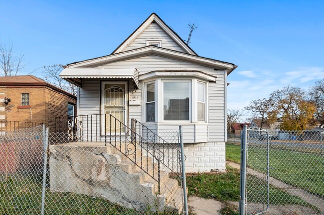
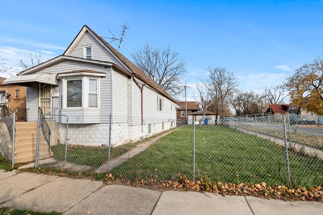
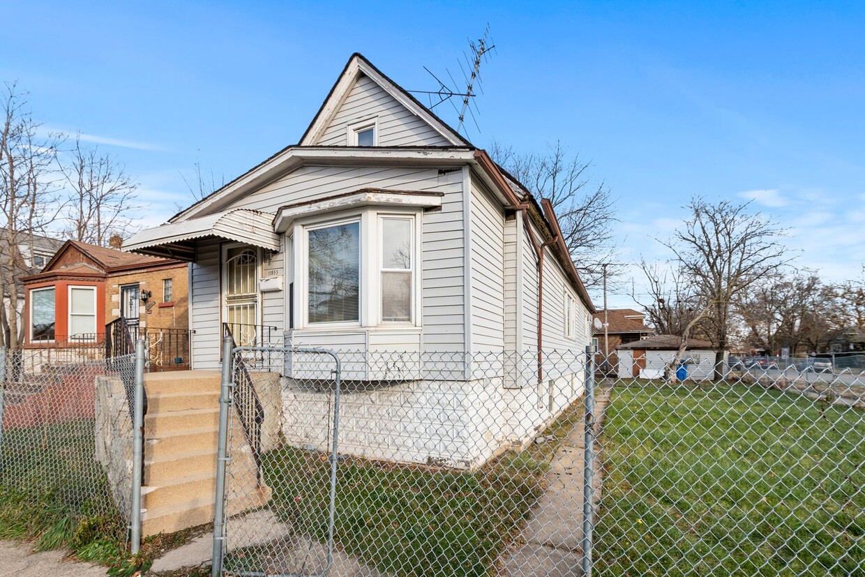
11955 S State St
Chicago, IL 60628
Favorites
11955 S State St

Favorites
Check Back Soon for Upcoming Availability
| Beds | Baths | Average SF |
|---|---|---|
| 4 Bedrooms 4 Bedrooms 4 Br | 1 Bath 1 Bath 1 Ba | 1,220 SF |
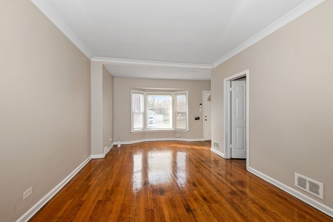
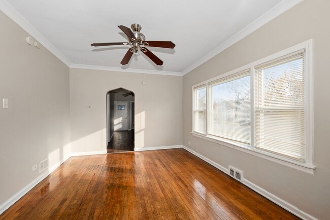
About This Property
Introducing 11955 S State St, a charming 4-bedroom, 1-bathroom house located in the heart of Chicago, IL. This lovely home boasts a spacious back yard, perfect for outdoor entertaining or simply enjoying the fresh air. Inside, you'll find new appliances in the kitchen, making meal preparation a breeze. With multiple levels, there is plenty of space for everyone to spread out and relax. Don't miss out on the opportunity to make this house your new home. Contact us today to schedule a viewing!
11955 S State St is a house located in Cook County and the 60628 ZIP Code. This area is served by the Chicago Public Schools attendance zone.
11955 S State St,
Chicago,
IL
60628
West Pullman is an urban neighborhood in Southside Chicago about 15 miles from the city’s center via Interstate 94 or public transit. West Pullman is bounded by the Little Calumet River to the south, making riverfront parks like Whistler Woods Forest Preserve accessible from the neighborhood. The community itself is filled with residential areas with a variety of affordable apartments, condos, and homes for rent. Shops and restaurants as well as community parks like West Pullman Park dot the area as well. Features outside of town include golf courses, plazas like Marshfield Plaza, and the parks and trails around Lake Michigan that are located less than 10 miles west.
Learn more about living in West PullmanBelow are rent ranges for similar nearby apartments
Education
| Colleges & Universities | Distance | ||
|---|---|---|---|
| Colleges & Universities | Distance | ||
| Drive: | 9 min | 3.5 mi | |
| Drive: | 11 min | 5.3 mi | |
| Drive: | 17 min | 7.6 mi | |
| Drive: | 20 min | 10.8 mi |
11955 S State St is within 9 minutes or 3.5 miles from Chicago State University. It is also near South Suburban College and Saint Xavier University.
Schools


Public Elementary & Middle School
Grades PK-8
356 Students
Attendance Zone
Public High School
Grades 9-12
366 Students
Attendance Zone
Private Elementary, Middle & High School
Grades PK-12
Nearby
Private Elementary & Middle School
Grades PK-8
Nearby
School data provided by
 The GreatSchools Rating helps parents compare schools within a state based on a variety of school quality indicators and provides a helpful picture of how effectively each school serves all of its students. Ratings are on a scale of 1 (below average) to 10 (above average) and can include test scores, college readiness, academic progress, advanced courses, equity, discipline and attendance data. We also advise parents to visit schools, consider other information on school performance and programs, and consider family needs as part of the school selection process.
View GreatSchools Rating Methodology
Data provided by GreatSchools.org © 2026. All rights reserved.
View GreatSchools Rating Methodology
Data provided by GreatSchools.org © 2026. All rights reserved.
Transportation options available in Chicago include 87Th Street Station, located 4.3 miles from 11955 S State St. 11955 S State St is near Chicago Midway International, located 15.0 miles or 26 minutes away, and Chicago O'Hare International, located 31.9 miles or 48 minutes away.
| Transit / Subway | Distance | ||
|---|---|---|---|
| Transit / Subway | Distance | ||
|
|
Drive: | 7 min | 4.3 mi |
|
|
Drive: | 10 min | 5.4 mi |
|
|
Drive: | 11 min | 6.2 mi |
|
|
Drive: | 10 min | 6.6 mi |
|
|
Drive: | 14 min | 8.3 mi |
| Commuter Rail | Distance | ||
|---|---|---|---|
| Commuter Rail | Distance | ||
|
|
Walk: | 3 min | 0.2 mi |
|
|
Walk: | 12 min | 0.6 mi |
|
|
Drive: | 3 min | 1.2 mi |
|
|
Drive: | 3 min | 1.4 mi |
|
|
Drive: | 3 min | 1.8 mi |
| Airports | Distance | ||
|---|---|---|---|
| Airports | Distance | ||
|
Chicago Midway International
|
Drive: | 26 min | 15.0 mi |
|
Chicago O'Hare International
|
Drive: | 48 min | 31.9 mi |
Walkability Near 11955 S State St Chicago, IL 60628
Getting Around
 What do Walkability, Transit, Drivability, and Bikeability mean?
Walkability measures the walking distance to day-to-day needs.
Transit measures access to public transportation.
Drivability measures congestion, parking availability, and access to major roads.
Bikeability measures the suitability for cycling.
How It Works
What do Walkability, Transit, Drivability, and Bikeability mean?
Walkability measures the walking distance to day-to-day needs.
Transit measures access to public transportation.
Drivability measures congestion, parking availability, and access to major roads.
Bikeability measures the suitability for cycling.
How It Works
Moderately Walkable
Walkability
60
/ 100
Good Public Transit
Transit
70
/ 100
Moderately Drivable
Drivability
70
/ 100
Fairly Bikeable
Bikeability
50
/ 100
Scores provided by
-
Soundscore™
-
/ 100
Traffic
-Airport
-Businesses
-Scores provided by
HowLoud What is a Sound Score Rating? A Sound Score Rating aggregates noise caused by vehicle traffic, airplane traffic and local sources. How It WorksTime and distance from 11955 S State St.
| Shopping Centers | Distance | ||
|---|---|---|---|
| Shopping Centers | Distance | ||
| Drive: | 3 min | 1.3 mi | |
| Drive: | 5 min | 1.9 mi | |
| Drive: | 5 min | 1.9 mi |
11955 S State St has 3 shopping centers within 1.9 miles, which is about a 5-minute drive. The miles and minutes will be for the farthest away property.
| Parks and Recreation | Distance | ||
|---|---|---|---|
| Parks and Recreation | Distance | ||
|
West Pullman Park
|
Walk: | 18 min | 1.0 mi |
|
Beaubien Woods
|
Drive: | 8 min | 3.2 mi |
|
Prospect Gardens Park
|
Drive: | 8 min | 3.8 mi |
|
Graver Park
|
Drive: | 9 min | 4.5 mi |
|
Calumet Woods
|
Drive: | 10 min | 4.8 mi |
11955 S State St has 5 parks within 4.8 miles, including West Pullman Park, Beaubien Woods, and Prospect Gardens Park.
| Hospitals | Distance | ||
|---|---|---|---|
| Hospitals | Distance | ||
| Drive: | 3 min | 1.4 mi | |
| Drive: | 10 min | 5.9 mi | |
| Drive: | 12 min | 6.8 mi |
11955 S State St has 3 hospitals within 6.8 miles, the nearest is Roseland Community Hospital which is 1.4 miles away and a 3 minute drive.
| Military Bases | Distance | ||
|---|---|---|---|
| Military Bases | Distance | ||
| Drive: | 57 min | 38.9 mi | |
| Drive: | 57 min | 39.5 mi | |
| Drive: | 68 min | 43.9 mi |
11955 S State St has 3 military bases within 43.9 miles, the nearest is US Military Reservation Naperville which is 38.9 miles away and a 57 minute drive.
You May Also Like
Similar Rentals Nearby


What Are Walk Score®, Transit Score®, and Bike Score® Ratings?
Walk Score® measures the walkability of any address. Transit Score® measures access to public transit. Bike Score® measures the bikeability of any address.
What is a Sound Score Rating?
A Sound Score Rating aggregates noise caused by vehicle traffic, airplane traffic and local sources.
11955 S State St
Chicago, IL 60628