
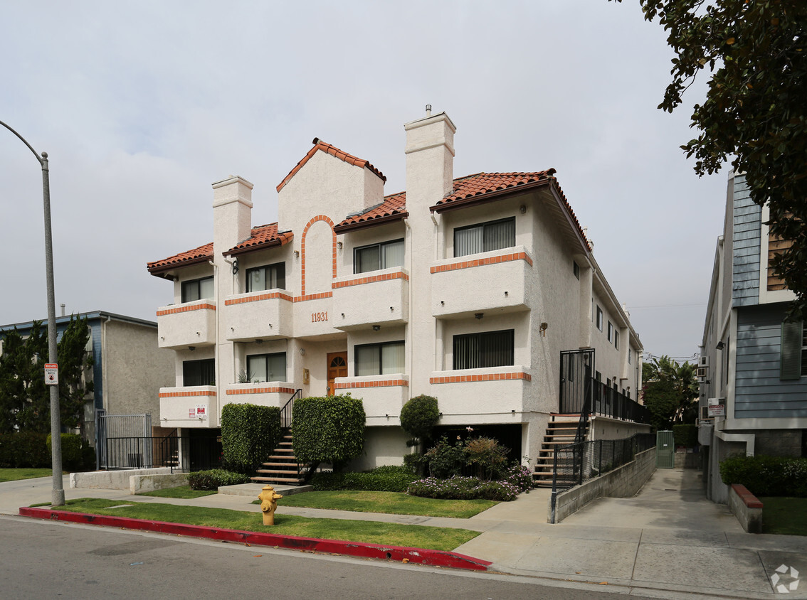
11931 Avon Way
11931 Avon Way,
Los Angeles,
CA
90066
-
Monthly Rent
$2,795
-
Bedrooms
2 bd
-
Bathrooms
2 ba
-
Square Feet
1,000 sq ft

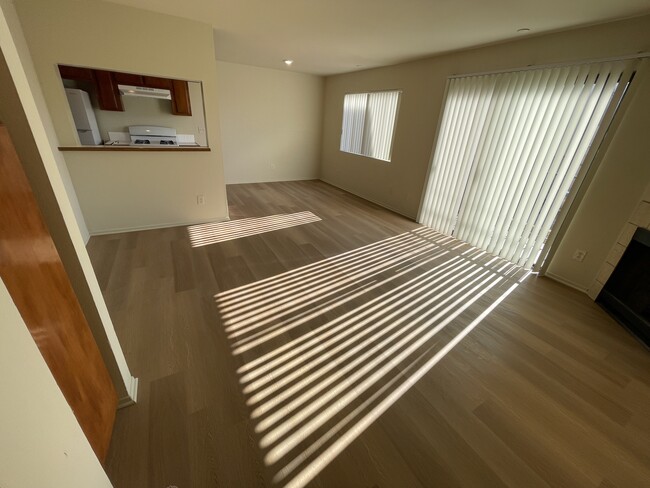
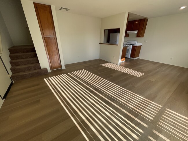
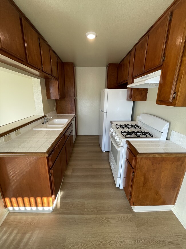
2-car Gated Parking. Unit has an alarm, Central Westside Location, Mar Vista (Just South of Washington Blvd.) Quick Access to the 10 & 405 Freeways, Near Santa Monica, Century City, Westwood, Brentwood & Beverly Hills, gated garage., Window Blinds, Newly Remodeled. Open House Daily 10 am to 4 pm. Virtual Tour: https://youtu.be/z9CuxnlUyd4
Highlights
- Bike-Friendly Area
- Fireplace
- Gated
- Balcony
Pricing & Floor Plans
Fees and Policies
The fees listed below are community-provided and may exclude utilities or add-ons. All payments are made directly to the property and are non-refundable unless otherwise specified.
-
One-Time Basics
-
Due at Application
-
Application Fee Per ApplicantCharged per applicant.$30
-
-
Due at Application
-
Covered
Property Fee Disclaimer: Based on community-supplied data and independent market research. Subject to change without notice. May exclude fees for mandatory or optional services and usage-based utilities.
Details
Property Information
-
Built in 1986
-
9 units/2 stories
About 11931 Avon Way Los Angeles, CA 90066
2-car Gated Parking. Unit has an alarm, Central Westside Location, Mar Vista (Just South of Washington Blvd.) Quick Access to the 10 & 405 Freeways, Near Santa Monica, Century City, Westwood, Brentwood & Beverly Hills, gated garage., Window Blinds, Newly Remodeled. Open House Daily 10 am to 4 pm. Virtual Tour: https://youtu.be/z9CuxnlUyd4
11931 Avon Way is an apartment community located in Los Angeles County and the 90066 ZIP Code. This area is served by the Los Angeles Unified attendance zone.
Contact
Community Amenities
- Gated
Apartment Features
- Heating
- Fireplace
- Dishwasher
- Balcony
Extending from the 405 to Marina Del Rey, Del Rey provides everything you love about LA: the gorgeous beaches, impossibly tall, skinny palm trees, and that laidback atmosphere that no other city does quite like LA. Del Rey is next door to some of the city's most-loved beaches, including Venice Beach and Muscle Beach. Go shopping along the Venice Beach Boardwalk or watch the sailboats from the Marina Del Rey Jetty.
Culver City surrounds Del Rey on three sides. Del Rey is convenient to the Los Angeles International Airport, Loyola Marymount University, and the Ballona Wetlands Ecological Reserve. Del Rey is roughly 12 miles southwest of Downtown Los Angeles, convenient for trips to Crypto.com Arena, Peacock Theater, and the Los Angeles Convention Center.
Learn more about living in Del ReyCompare neighborhood and city base rent averages by bedroom.
| Del Rey | Los Angeles, CA | |
|---|---|---|
| Studio | $2,300 | $1,706 |
| 1 Bedroom | $2,717 | $2,172 |
| 2 Bedrooms | $3,454 | $2,989 |
| 3 Bedrooms | $4,834 | $4,272 |
- Gated
- Heating
- Fireplace
- Dishwasher
- Balcony
| Monday | 12am - 12am |
|---|---|
| Tuesday | 12am - 12am |
| Wednesday | 12am - 12am |
| Thursday | 12am - 12am |
| Friday | 12am - 12am |
| Saturday | 12am - 12am |
| Sunday | 12am - 12am |
| Colleges & Universities | Distance | ||
|---|---|---|---|
| Colleges & Universities | Distance | ||
| Drive: | 6 min | 2.4 mi | |
| Drive: | 6 min | 2.8 mi | |
| Drive: | 6 min | 3.0 mi | |
| Drive: | 8 min | 3.1 mi |


View GreatSchools Rating Methodology
Data provided by GreatSchools.org © 2026. All rights reserved.
Transportation options available in Los Angeles include Culver City, located 3.1 miles from 11931 Avon Way. 11931 Avon Way is near Los Angeles International, located 5.1 miles or 11 minutes away, and Bob Hope, located 22.1 miles or 31 minutes away.
| Transit / Subway | Distance | ||
|---|---|---|---|
| Transit / Subway | Distance | ||
|
|
Drive: | 6 min | 3.1 mi |
|
|
Drive: | 7 min | 3.2 mi |
| Drive: | 6 min | 3.5 mi | |
|
|
Drive: | 8 min | 3.5 mi |
|
|
Drive: | 7 min | 3.9 mi |
| Commuter Rail | Distance | ||
|---|---|---|---|
| Commuter Rail | Distance | ||
|
|
Drive: | 22 min | 13.5 mi |
|
|
Drive: | 24 min | 13.6 mi |
|
|
Drive: | 28 min | 16.9 mi |
|
|
Drive: | 32 min | 22.1 mi |
|
|
Drive: | 31 min | 22.9 mi |
| Airports | Distance | ||
|---|---|---|---|
| Airports | Distance | ||
|
Los Angeles International
|
Drive: | 11 min | 5.1 mi |
|
Bob Hope
|
Drive: | 31 min | 22.1 mi |
Time and distance from 11931 Avon Way.
| Shopping Centers | Distance | ||
|---|---|---|---|
| Shopping Centers | Distance | ||
| Walk: | 7 min | 0.4 mi | |
| Walk: | 12 min | 0.6 mi | |
| Walk: | 12 min | 0.6 mi |
| Parks and Recreation | Distance | ||
|---|---|---|---|
| Parks and Recreation | Distance | ||
|
Ballona Creek Trail - Ballona Wetlands Ecological Reserve Access
|
Walk: | 16 min | 0.9 mi |
|
Santa Monica Pier Aquarium
|
Drive: | 12 min | 5.4 mi |
|
Kenneth Hahn State Recreation Area
|
Drive: | 14 min | 5.7 mi |
|
Mathias Botanical Garden
|
Drive: | 10 min | 6.1 mi |
|
Santa Monica State Beach
|
Drive: | 12 min | 7.8 mi |
| Hospitals | Distance | ||
|---|---|---|---|
| Hospitals | Distance | ||
| Drive: | 4 min | 2.1 mi | |
| Drive: | 9 min | 4.1 mi | |
| Drive: | 10 min | 6.0 mi |
| Military Bases | Distance | ||
|---|---|---|---|
| Military Bases | Distance | ||
| Drive: | 13 min | 8.7 mi |
11931 Avon Way Photos
-
Primary Photo
-
-
-
-
-
-
-
-
Nearby Apartments
Within 50 Miles of 11931 Avon Way Los Angeles, CA 90066
-
11748 Courtleigh Dr
Los Angeles, CA 90066
$2,795
2 Br 0.2 mi
-
12630 Mitchell Ave
Los Angeles, CA 90066
$2,795
2 Br 0.9 mi
-
12741 Mitchell Ave
Los Angeles, CA 90066
$2,795 - $3,696
2-3 Br 1.0 mi
-
12736 Caswell Ave
Los Angeles, CA 90066
$2,995
2 Br 1.1 mi
-
3670 Midvale Ave
Los Angeles, CA 90034
$4,495
4 Br 1.6 mi
-
3640 Westwood Blvd
Los Angeles, CA 90034
$4,495
4 Br 1.7 mi
11931 Avon Way does not offer in-unit laundry or shared facilities. Please contact the property to learn about nearby laundry options.
Utilities are not included in rent. Residents should plan to set up and pay for all services separately.
Parking is available at 11931 Avon Way. Contact this property for details.
11931 Avon Way has two-bedrooms apartments renting for $2,795/mo.
11931 Avon Way does not allow pets, though service animals are always welcome in accordance with applicable laws.
A good rule of thumb is to spend no more than 30% of your gross income on rent. Based on the lowest available rent of $2,795 for a two-bedrooms, you would need to earn about $111,800 per year to qualify. Want to double-check your budget? Calculate how much rent you can afford with our Rent Affordability Calculator.
11931 Avon Way is not currently offering any rent specials. Check back soon, as promotions change frequently.
While 11931 Avon Way does not offer Matterport 3D tours, renters can request a tour directly through our online platform.
What Are Walk Score®, Transit Score®, and Bike Score® Ratings?
Walk Score® measures the walkability of any address. Transit Score® measures access to public transit. Bike Score® measures the bikeability of any address.
What is a Sound Score Rating?
A Sound Score Rating aggregates noise caused by vehicle traffic, airplane traffic and local sources
11931 Avon Way
Los Angeles, CA 90066
Property Manager Responded