
$1,923
/ Month
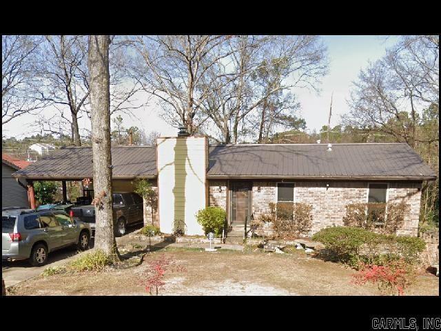
11808 Ashwood Dr
Little Rock, AR 72211
Today
|
Edit
Favorites
501-221-8888
-
Bedrooms
4
-
Bathrooms
3
-
Square Feet
2,189 sq ft
-
Available
Not Available
Highlight
- Central Heating and Cooling System
11808 Ashwood Dr

Favorites
About This Home
$1,923 deposit,
Not Available
*WEST LITTLE ROCK* ¡ESPACIOSA CASA EN LA SUBDIVISIÓN BIRCHWOOD! Esta casa de 4 dormitorios y 3 baños cuenta con casi 2200 pies cuadrados de espacio habitable. 3 dormitorios en la planta superior, incluyendo el principal con baño privado y vestidor con muebles empotrados, además de un baño completo para invitados. La planta baja cuenta con un cuarto dormitorio y un área adicional. Conexiones para lavadora y secadora incluidas en el tercer baño completo. El solárium en la parte trasera de la casa da a una amplia terraza y un patio cercado. ¡Cochera para 2 autos! ¡Se admiten mascotas! ¡Disponible a mediados de febrero de 2026!
11808 Ashwood Dr is a house located in Pulaski County and the 72211 ZIP Code. This area is served by the Little Rock attendance zone.
* Price shown is base rent. Excludes user-selected optional fees and variable or usage-based fees and required charges due at or prior to move-in or at move-out. Price, availability, fees, and any applicable rent special are subject to change without notice.
* Square footage definitions vary. Displayed square footage is approximate.
Home Details
Home Type
House
Year Built
Built in 1971
Bedrooms and Bathrooms
3 Full Bathrooms
4 Bedrooms
Interior Spaces
2,189 Sq Ft Home
Kitchen
Oven or Range
Dishwasher
Disposal
Laundry
Washer and Dryer Hookup
Listing and Financial Details
Security Deposit $1,923
Parking
2 Carport Spaces
2 Car Garage
Utilities
Central Heating and Cooling System
Community Details
Pet Policy
Call for details about the types of pets allowed
Pet Deposit $250
Fees and Policies
The fees listed below are community-provided and may exclude utilities or add-ons. All payments are made directly to the property and are non-refundable unless otherwise specified. Use the Cost Calculator to determine costs based on your needs.
-
One-Time Basics
-
Due at Move-In
-
Security Deposit - RefundableCharged per unit.$1,923
-
-
Due at Move-In
Property Fee Disclaimer: Based on community-supplied data and independent market research. Subject to change without notice. May exclude fees for mandatory or optional services and usage-based utilities.
Contact
- Listed by Roy Rainey Jr. | Rainey Realty, Inc.
- Phone Number
- Contact
-
Source
 Cooperative Arkansas Realtors® Multiple Listings Services, Inc.
Copyright ©2026 Cooperative Arkansas Realtors® Multiple Listings Services, Inc.
Location
Get Directions
Just a 12-minute drive west from Little Rock via Interstate 630, the Walnut Valley neighborhood features affordable home prices and average rental costs that make it an excellent place to live. A wide array of amenities and access to a highly-rated school system make this area attractive.
Low-rise, affordable apartments and single-family homes make up the bulk of the rental market in Walnut Valley, making it perfect for renters looking for a little more value while still being relatively close to Downtown Little Rock.
Learn more about living in Walnut Valley
Education
| Colleges & Universities | Distance | ||
|---|---|---|---|
| Colleges & Universities | Distance | ||
| Drive: | 10 min | 5.1 mi | |
| Drive: | 10 min | 5.7 mi | |
| Drive: | 12 min | 7.8 mi | |
| Drive: | 22 min | 14.6 mi |
11808 Ashwood Dr is within 10 minutes or 5.1 miles from Univ. of Ark. Medical Scis.. It is also near UA Little Rock and Philander Smith College.
Schools


Public Elementary School
Grades K-5
352 Students
Attendance Zone
Public Middle School
Grades 6-8
878 Students
Attendance Zone
Charter Middle School
Grades 6-8
503 Students
Nearby
Charter High School
Grades 9-12
412 Students
Nearby
Private Elementary School
Grades PK-6
73 Students
Nearby
Private Elementary, Middle & High School
Grades PK-12
1,323 Students
Nearby
School data provided by
 The GreatSchools Rating helps parents compare schools within a state based on a variety of school quality indicators and provides a helpful picture of how effectively each school serves all of its students. Ratings are on a scale of 1 (below average) to 10 (above average) and can include test scores, college readiness, academic progress, advanced courses, equity, discipline and attendance data. We also advise parents to visit schools, consider other information on school performance and programs, and consider family needs as part of the school selection process.
View GreatSchools Rating Methodology
Data provided by GreatSchools.org © 2026. All rights reserved.
View GreatSchools Rating Methodology
Data provided by GreatSchools.org © 2026. All rights reserved.
Transportation options available in Little Rock include 2Nd St & Center St, located 8.6 miles from 11808 Ashwood Dr. 11808 Ashwood Dr is near Bill and Hillary Clinton Ntl/Adams Field, located 12.5 miles or 19 minutes away.
| Transit / Subway | Distance | ||
|---|---|---|---|
| Transit / Subway | Distance | ||
| Drive: | 13 min | 8.6 mi | |
| Drive: | 12 min | 8.6 mi | |
| Drive: | 13 min | 8.9 mi | |
| Drive: | 13 min | 9.0 mi | |
| Drive: | 13 min | 9.3 mi |
| Commuter Rail | Distance | ||
|---|---|---|---|
| Commuter Rail | Distance | ||
|
|
Drive: | 13 min | 7.8 mi |
| Airports | Distance | ||
|---|---|---|---|
| Airports | Distance | ||
|
Bill and Hillary Clinton Ntl/Adams Field
|
Drive: | 19 min | 12.5 mi |
Time and distance from 11808 Ashwood Dr.
| Shopping Centers | Distance | ||
|---|---|---|---|
| Shopping Centers | Distance | ||
| Walk: | 6 min | 0.3 mi | |
| Walk: | 6 min | 0.3 mi | |
| Walk: | 7 min | 0.4 mi |
11808 Ashwood Dr has 3 shopping centers within 0.4 mile, which is about a 7-minute walk. The miles and minutes will be for the farthest away property.
| Parks and Recreation | Distance | ||
|---|---|---|---|
| Parks and Recreation | Distance | ||
|
Little Rock Zoo
|
Drive: | 8 min | 5.0 mi |
|
Central High School National Historic Site
|
Drive: | 11 min | 6.8 mi |
|
Museum of Discovery
|
Drive: | 13 min | 9.2 mi |
|
Pinnacle Mountain State Park
|
Drive: | 21 min | 9.6 mi |
|
Burns Park
|
Drive: | 17 min | 11.7 mi |
11808 Ashwood Dr has 5 parks within 11.7 miles, including Little Rock Zoo, Central High School National Historic Site, and Museum of Discovery.
| Hospitals | Distance | ||
|---|---|---|---|
| Hospitals | Distance | ||
| Drive: | 3 min | 1.8 mi | |
| Drive: | 8 min | 4.7 mi | |
| Drive: | 9 min | 4.9 mi |
11808 Ashwood Dr has 3 hospitals within 4.9 miles, the nearest is Arkansas Heart Hospital which is 1.8 miles away and a 3 minute drive.
| Military Bases | Distance | ||
|---|---|---|---|
| Military Bases | Distance | ||
| Drive: | 33 min | 18.9 mi | |
| Drive: | 38 min | 26.5 mi | |
| Drive: | 41 min | 26.7 mi |
11808 Ashwood Dr has 3 military bases within 26.7 miles, the nearest is Camp Joseph T. Robinson Hill which is 18.9 miles away and a 33 minute drive.
You May Also Like
Similar Rentals Nearby


What Are Walk Score®, Transit Score®, and Bike Score® Ratings?
Walk Score® measures the walkability of any address. Transit Score® measures access to public transit. Bike Score® measures the bikeability of any address.
What is a Sound Score Rating?
A Sound Score Rating aggregates noise caused by vehicle traffic, airplane traffic and local sources

11808 Ashwood Dr
Little Rock, AR 72211