
$1,800
Total Monthly Price
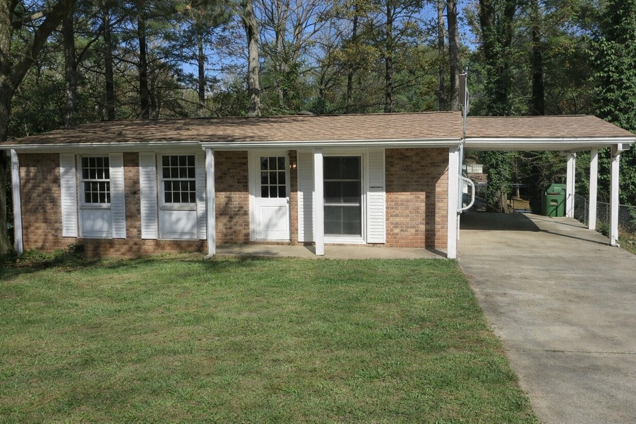
117 Glenrose Cir SW
Atlanta, GA 30354
Favorites
-
Bedrooms
3
-
Bathrooms
2
-
Square Feet
1,008 sq ft
-
Available
Available Now
Highlights
- Playground
- Tennis Court
- Basketball Court
117 Glenrose Cir SW

Favorites
About This Home
12 Month Lease,
$2,000 deposit,
Available Now
Welcome to Glenrose Circle SW, a well-located Atlanta home in the Glenrose Heights area of South Atlanta. This 3-bedroom home offers approximately 1,008 square feet of living space with a practical layout and central Atlanta convenience. The property is positioned near Hartsfield-Jackson Atlanta International Airport, major highways, neighborhood schools, parks, shopping, dining, and major employment corridors. Located in Fulton County and served by Atlanta Public Schools, the home offers convenient access to I-75, I-85, I-285, Downtown Atlanta, Hapeville, East Point, College Park, and the broader south metro area. Glenrose Circle SW provides a strong combination of location, affordability, and accessibility. Nearby Schools • Heritage Academy Elementary School — public elementary school; approximately 1.1–1.2 miles away. • Long Middle School — public middle school; approximately 0.3 miles away. • South Atlanta High School — public high school; approximately 1.7–1.8 miles away. • Hank Aaron New Beginnings Academy — nearby Atlanta Public Schools choice/program school. • Atlanta Public Schools — school assignments should be verified directly with the school district. Nearby Shopping • Camp Creek Marketplace — major shopping and dining destination near Hartsfield-Jackson, with a wide range of stores, restaurants, and services. • Camp Creek Marketplace anchor retailers — public center information lists major retailers including Marshalls, Ross, T.J. Maxx, PetSmart, Old Navy, Dollar Tree, Five Below, Shoe Carnival, with nearby/shadow anchors including Target, Publix, Lowe’s, and BJ’s Wholesale Club. • Hapeville commercial district — nearby local shopping, restaurants, coffee shops, and service businesses. • Cleveland Avenue / Metropolitan Parkway corridors — convenient access to everyday retail, gas, grocery, and service businesses. • Downtown Atlanta retail and services — accessible via I-75/I-85 and surface-street routes. Nearby Dining • Historic Hapeville restaurants — nearby dining district with local and casual options; Hapeville’s restaurant guide highlights spots including JPresso, The Brass Tap, Airport View, and American Deli. • Hapeville dining district — home to local favorites, ethnic cuisine, and the original Chick-fil-A Dwarf House area. • Volare Bistro — wine-focused Mediterranean dining in downtown Hapeville. • Folk Art — Hapeville — Southern-inspired restaurant with a Hapeville location. • Camp Creek Marketplace restaurants — convenient mix of casual dining and national restaurant options near the airport. • Downtown Atlanta restaurants — broader restaurant access within a short drive toward the city center. Nearby Parks & Recreation • Empire Park — located at 245 Oak Drive SE, Atlanta, GA 30354; City of Atlanta parks data lists it as an 11.8-acre neighborhood park. • Empire Park recreation amenities — public park listings describe amenities such as a playground, basketball court, baseball field, tennis courts, paved paths, picnic areas, and shaded green space. • Lake Charlotte Nature Preserve / Mount Zion Nature Preserve area — City of Atlanta parks data lists nature preserve acreage in the 30354 area. • Southside Park / Lakewood-area recreation access — additional southeast Atlanta green space and recreation options within the broader area. • Glenrose Heights neighborhood green space — neighborhood guides describe Glenrose Heights as having its own park, creek, playground, and after-school programming. Nearby Hospitals & Medical Centers • Southern Regional Medical Center — located at 11 Upper Riverdale Road SW, Riverdale, GA 30274; a 331-bed acute care hospital serving the south metro area. • Grady Memorial Hospital — located at 80 Jesse Hill Jr Drive SE, Atlanta, GA 30303, with 24-hour emergency care. • Emory University Hospital Midtown — located at 550 Peachtree Street NE, Atlanta, GA 30308; Emory describes it as a more than 600-bed specialized care hospital. • Children’s Hughes Spalding Hospital — located downtown near Grady Memorial Hospital; includes a 24-hour Emergency Department. • Grady South Emergency Department — Grady has announced/opened south Fulton emergency access, useful as a regional healthcare note for south metro residents. Nearby Military Bases / Military Facilities • Fort Gillem Enclave / Fort Gillem area — located in Forest Park; Army Reserve listings identify Fort Gillem Enclave facilities and units in the area. • Fort Gillem U.S. Army Reserve Center — military-related facility area in Forest Park, with Army Reserve units listed at Fort Gillem. • Dobbins Air Reserve Base — active Air Force Reserve installation in Marietta, home of the 94th Airlift Wing. • Clay National Guard Center — Georgia National Guard facility in Marietta; relevant as a regional military facility. • Important marketing note: The closest military-related facility is the Fort Gillem / Forest Park area; Dobbins and Clay National Guard Center are regional metro Atlanta facilities rather than immediate neighborhood amenities. Nearby Highways & Major Roads • I-75 — major north-south interstate access near the Glenrose Heights / Hapeville / airport area. • I-85 — major northeast-southwest interstate route serving Atlanta and the airport corridor. • I-285 — Atlanta’s perimeter highway, providing regional access around the metro area. • I-75 / I-85 Downtown Connector — direct route into Downtown and Midtown Atlanta. • Cleveland Avenue SW / SE — nearby local corridor with retail, services, and access toward Hapeville and East Point. • Metropolitan Parkway SW — major south Atlanta corridor connecting toward Downtown, College Park, and south metro areas. • Hutchens Road SE / Jonesboro Road SE — nearby local connectors serving the South Atlanta area. • Hartsfield-Jackson Atlanta International Airport — located nearby; the airport’s domestic terminal address is 6000 North Terminal Parkway, Atlanta, GA 30320, and the international terminal is on Maynard H. Jackson Jr. Boulevard in Atlanta 30354. Applicants should have: • No evictions or judgments within the past two years • Verifiable household income at least three times the monthly payment amount • Accurate information on the preliminary questionnaire and application Pets: Pets may be allowed with a pet fee and monthly pet rent per pet. Please discuss with us.
117 Glenrose Cir Sw is a house located in Fulton County and the 30354 ZIP Code. This area is served by the Atlanta Public Schools attendance zone.
* Price shown is total price based on community-supplied monthly required fees. Excludes user-selected optional fees and variable or usage-based fees and required charges due at or prior to move-in or at move-out. Price, availability, fees, and any applicable rent special are subject to change without notice.
* Square footage definitions vary. Displayed square footage is approximate.
House Features
- Range
- Playground
- Basketball Court
- Tennis Court
- Walking/Biking Trails
- Picnic Area
Contact
- Contact
Location
Get Directions
Southeast Atlanta is just one of the many major neighborhoods within the sprawling Atlanta metropolitan area. This area stretches along the east side of I-75, up from Mountain View to Ormewood Park. The neighborhood boasts a diverse mix of residents and offers a variety of rentals, from single-family homes to charming apartment complexes.
Faithful to Atlanta’s reputation as a “city within a forest,” Southeast Atlanta encompasses a large number of parks and green spaces along with its tree-lined streets. Lake Charlotte Nature Preserve and South Bend Park are all popular gathering spots for a breath of fresh air. There are local watering holes and soul food restaurants that serve the area, and the Starlight Drive-In Theatre lies on the neighborhood’s east border.
With I-75 and Moreland Ave. nearby, getting into the heart of the city or other popular areas like East Atlanta is simple.
Learn more about living in Southeast Atlanta
Education
| Colleges & Universities | Distance | ||
|---|---|---|---|
| Colleges & Universities | Distance | ||
| Drive: | 7 min | 3.7 mi | |
| Drive: | 11 min | 4.4 mi | |
| Drive: | 13 min | 6.3 mi | |
| Drive: | 14 min | 7.7 mi |
117 Glenrose Cir SW is within 7 minutes or 3.7 miles from Atlanta Metropolitan State. It is also near Atlanta Technical College and Morehouse School of Medicine.
Schools


Public Elementary School
Grades PK-5
351 Students
Attendance Zone
Public Middle & High School
Grades 6-12
212 Students
Nearby
Public Middle School
Grades 6-8
806 Students
Attendance Zone
Public Middle School
Grades 6-8
601 Students
Attendance Zone
Private Elementary, Middle & High School
Grades K-12
10 Students
Nearby
Private Elementary & Middle School
Grades PK-8
280 Students
Nearby
School data provided by
 The GreatSchools Rating helps parents compare schools within a state based on a variety of school quality indicators and provides a helpful picture of how effectively each school serves all of its students. Ratings are on a scale of 1 (below average) to 10 (above average) and can include test scores, college readiness, academic progress, advanced courses, equity, discipline and attendance data. We also advise parents to visit schools, consider other information on school performance and programs, and consider family needs as part of the school selection process.
View GreatSchools Rating Methodology
Data provided by GreatSchools.org © 2026. All rights reserved.
View GreatSchools Rating Methodology
Data provided by GreatSchools.org © 2026. All rights reserved.
Transportation options available in Atlanta include East Point, located 4.2 miles from 117 Glenrose Cir SW. 117 Glenrose Cir SW is near Hartsfield - Jackson Atlanta International, located 3.7 miles or 9 minutes away.
| Transit / Subway | Distance | ||
|---|---|---|---|
| Transit / Subway | Distance | ||
|
|
Drive: | 9 min | 4.2 mi |
|
|
Drive: | 9 min | 4.5 mi |
|
|
Drive: | 10 min | 5.0 mi |
|
|
Drive: | 9 min | 5.3 mi |
|
|
Drive: | 14 min | 6.5 mi |
| Commuter Rail | Distance | ||
|---|---|---|---|
| Commuter Rail | Distance | ||
|
|
Drive: | 17 min | 10.4 mi |
| Airports | Distance | ||
|---|---|---|---|
| Airports | Distance | ||
|
Hartsfield - Jackson Atlanta International
|
Drive: | 9 min | 3.7 mi |
Getting Around
 What do Walkability, Transit, Drivability, and Bikeability mean?
Walkability measures the walking distance to day-to-day needs.
Transit measures access to public transportation.
Drivability measures congestion, parking availability, and access to major roads.
Bikeability measures the suitability for cycling.
How It Works
What do Walkability, Transit, Drivability, and Bikeability mean?
Walkability measures the walking distance to day-to-day needs.
Transit measures access to public transportation.
Drivability measures congestion, parking availability, and access to major roads.
Bikeability measures the suitability for cycling.
How It Works
Fairly Walkable
Walkability
40
/ 100
Limited Public Transit
Transit
30
/ 100
Exceptionally Drivable
Drivability
100
/ 100
Fairly Bikeable
Bikeability
40
/ 100
Scores provided by
Active
Soundscore™
75
/ 100
Traffic
BusyAirport
BusyBusinesses
CalmScores provided by
HowLoud What is a Sound Score Rating? A Sound Score Rating aggregates noise caused by vehicle traffic, airplane traffic and local sources. How It WorksTime and distance from 117 Glenrose Cir SW.
| Shopping Centers | Distance | ||
|---|---|---|---|
| Shopping Centers | Distance | ||
| Walk: | 16 min | 0.8 mi | |
| Walk: | 18 min | 1.0 mi | |
| Drive: | 2 min | 1.1 mi |
117 Glenrose Cir SW has 3 shopping centers within 1.1 miles, which is about a 2-minute drive. The miles and minutes will be for the farthest away property.
| Parks and Recreation | Distance | ||
|---|---|---|---|
| Parks and Recreation | Distance | ||
|
The Georgia Capitol Museum
|
Drive: | 11 min | 6.1 mi |
|
Park Pride
|
Drive: | 11 min | 6.2 mi |
|
Zoo Atlanta
|
Drive: | 12 min | 6.3 mi |
|
West Atlanta Watershed Alliance (WAWA)
|
Drive: | 14 min | 6.8 mi |
|
Trees Atlanta
|
Drive: | 14 min | 7.7 mi |
117 Glenrose Cir SW has 5 parks within 7.7 miles, including Zoo Atlanta, The Georgia Capitol Museum, and West Atlanta Watershed Alliance (WAWA).
| Hospitals | Distance | ||
|---|---|---|---|
| Hospitals | Distance | ||
| Drive: | 12 min | 6.5 mi | |
| Drive: | 16 min | 7.2 mi | |
| Drive: | 13 min | 7.4 mi |
117 Glenrose Cir SW has 3 hospitals within 7.4 miles, the nearest is Grady Memorial Hospital which is 6.5 miles away and a 12 minute drive.
| Military Bases | Distance | ||
|---|---|---|---|
| Military Bases | Distance | ||
| Drive: | 10 min | 4.7 mi | |
| Drive: | 17 min | 7.9 mi | |
| Drive: | 38 min | 24.0 mi |
117 Glenrose Cir SW has 3 military bases within 24.0 miles, the nearest is Fort McPherson which is 4.7 miles away and a 10 minute drive.
Amenities
- Range
- Picnic Area
- Playground
- Basketball Court
- Tennis Court
- Walking/Biking Trails
117 Glenrose Cir SW Photos
117 Glenrose Cir SW
Atlanta, GA 30354