$1,945
Total Monthly Price
12 Month Lease
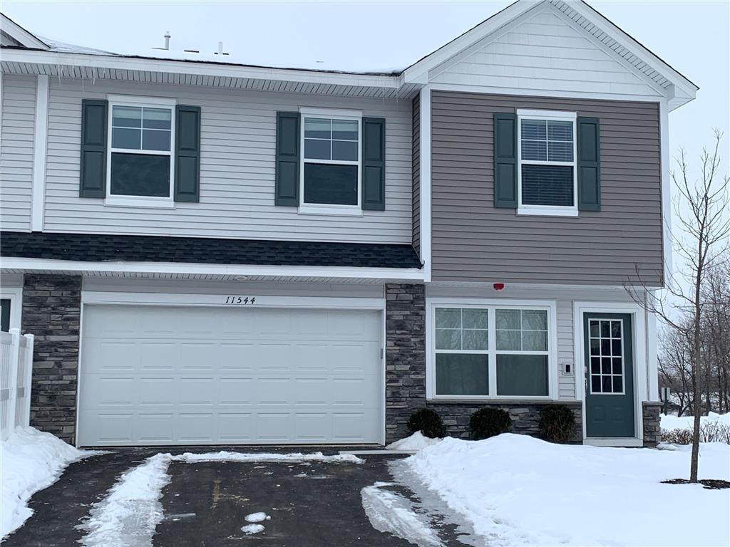
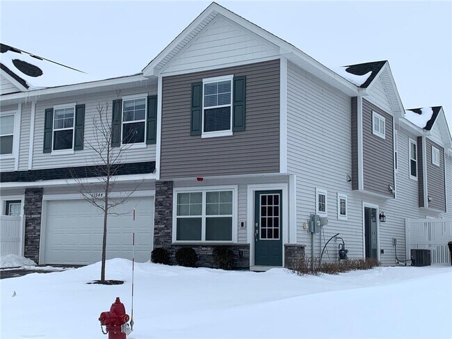
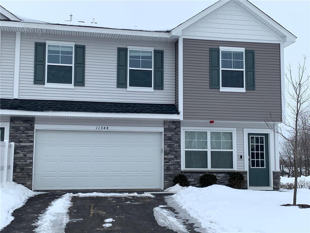
11544 Laurel Spgs Path
Maple Grove, MN 55311
Favorites
11544 Laurel Spgs Path

Favorites
Check Back Soon for Upcoming Availability
| Beds | Baths | Average SF |
|---|---|---|
| 3 Bedrooms 3 Bedrooms 3 Br | 2.5 Baths 2.5 Baths 2.5 Ba | 1,800 SF |
Fees and Policies
The fees listed below are community-provided and may exclude utilities or add-ons. All payments are made directly to the property and are non-refundable unless otherwise specified.
- Parking
-
Garage--
Details
Utilities Included
-
Trash Removal
Lease Options
-
12 Months
About This Property
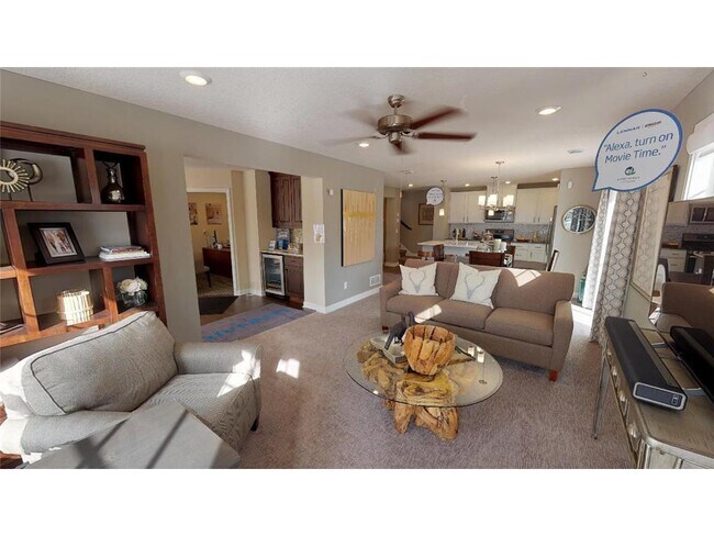
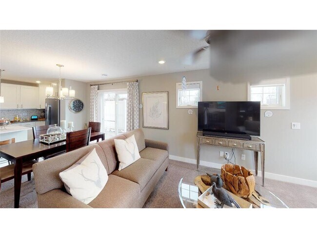
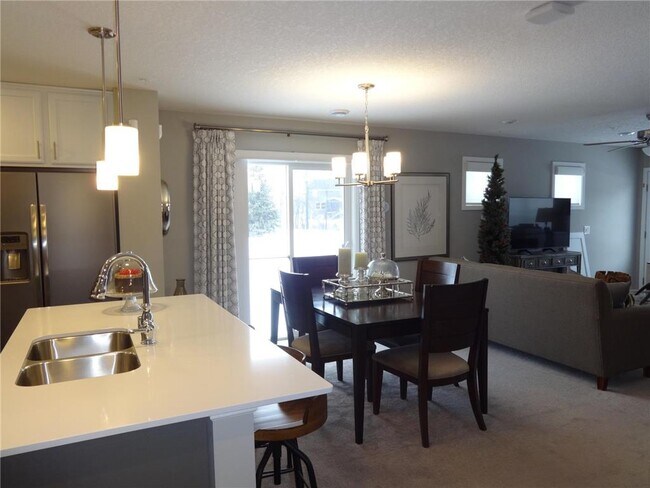
Available 4/1/2022. NO PHONE CALLS please. Request a showing online. Light filled, end unit, 2 story town home with white cabinetry in kitchen, 3 bedrooms upstairs, 2.5 bathroom and 2 car garage. Former model TH with custom paint and accents throughout. End unit with lots of windows and plenty of light. Near wooded walking trails with wetlands, ponds and mature trees around every corner.
11544 Laurel Spgs Path is a townhome located in Hennepin County and the 55311 ZIP Code. This area is served by the Elk River School District attendance zone.
Townhome Features
Dishwasher
Walk-In Closets
Island Kitchen
Microwave
- Ceiling Fans
- Smoke Free
- Dishwasher
- Disposal
- Island Kitchen
- Microwave
- Range
- Refrigerator
- Dining Room
- Walk-In Closets
- Laundry Facilities
11544 Laurel Spgs Path,
Maple Grove,
MN
55311
Maple Grove sits northwest of Minneapolis as Hennepin County's retail, medical, and cultural hub, drawing renters who want suburban space without losing easy access to a major city. Interstate 94 connects the city to downtown Minneapolis in roughly 20 minutes, and a commuter express bus makes car-free workday travel genuinely workable. Boston Scientific operates a significant regional facility here, and North Memorial Health Hospital anchors the local healthcare economy, giving the area a stable employment base beyond the metro core.
The city spans 36 square miles and holds more than 70,000 residents across several distinct areas. The Arbor Lakes and Main Street corridors offer walkable retail and dining within a well-planned mixed-use setting, while neighborhoods near Fish Lake and Weaver Lake put residents steps from beaches and paved shoreline trails.
Learn more about living in Maple GroveBelow are rent ranges for similar nearby apartments
| Beds | Average Size | Lowest | Typical | Premium |
|---|---|---|---|---|
| Studio Studio Studio | 518 Sq Ft | $2,467 | $2,770 | $3,086 |
| 1 Bed 1 Bed 1 Bed | 772 Sq Ft | $1,725 | $3,244 | $4,450 |
| 2 Beds 2 Beds 2 Beds | 1202-1203 Sq Ft | $3,050 | $4,127 | $6,821 |
| 3 Beds 3 Beds 3 Beds | 1979 Sq Ft | $3,500 | $4,727 | $5,553 |
| 4 Beds 4 Beds 4 Beds | 3754 Sq Ft | $3,750 | $5,890 | $7,500 |
Amenities
- Ceiling Fans
- Smoke Free
- Dishwasher
- Disposal
- Island Kitchen
- Microwave
- Range
- Refrigerator
- Dining Room
- Walk-In Closets
- Laundry Facilities
Expenses
Utilities Included
Trash Removal
Included
Education
| Colleges & Universities | Distance | ||
|---|---|---|---|
| Colleges & Universities | Distance | ||
| Drive: | 15 min | 9.5 mi | |
| Drive: | 25 min | 13.8 mi | |
| Drive: | 29 min | 22.0 mi | |
| Drive: | 30 min | 22.4 mi |
11544 Laurel Spgs Path is within 15 minutes or 9.5 miles from North Hennepin Comm. Coll.. It is also near Anoka-Ramsey C.C., Coon Rapids and University of St. Thomas.
Schools


Public Elementary School
Grades PK-5
774 Students
Nearby
Public Elementary & Middle School
Grades K-8
979 Students
Attendance Zone
Public Elementary School
Grades K-5
664 Students
Attendance Zone
Public High School
Grades 9-12
1,740 Students
Attendance Zone
Private Elementary, Middle & High School
Grades PK-12
453 Students
Nearby
Private Elementary School
Grades K-5
87 Students
Nearby
School data provided by
 The GreatSchools Rating helps parents compare schools within a state based on a variety of school quality indicators and provides a helpful picture of how effectively each school serves all of its students. Ratings are on a scale of 1 (below average) to 10 (above average) and can include test scores, college readiness, academic progress, advanced courses, equity, discipline and attendance data. We also advise parents to visit schools, consider other information on school performance and programs, and consider family needs as part of the school selection process.
View GreatSchools Rating Methodology
Data provided by GreatSchools.org © 2026. All rights reserved.
View GreatSchools Rating Methodology
Data provided by GreatSchools.org © 2026. All rights reserved.
Walkability Near 11544 Laurel Spgs Path Maple Grove, MN 55311
Getting Around
 What do Walkability, Transit, Drivability, and Bikeability mean?
Walkability measures the walking distance to day-to-day needs.
Transit measures access to public transportation.
Drivability measures congestion, parking availability, and access to major roads.
Bikeability measures the suitability for cycling.
How It Works
What do Walkability, Transit, Drivability, and Bikeability mean?
Walkability measures the walking distance to day-to-day needs.
Transit measures access to public transportation.
Drivability measures congestion, parking availability, and access to major roads.
Bikeability measures the suitability for cycling.
How It Works
Not Walkable
Walkability
10
/ 100
Minimal Public Transit
Transit
0
/ 100
Exceptionally Drivable
Drivability
100
/ 100
Somewhat Bikeable
Bikeability
20
/ 100
Scores provided by
-
Soundscore™
-
/ 100
Traffic
-Airport
-Businesses
-Scores provided by
HowLoud What is a Sound Score Rating? A Sound Score Rating aggregates noise caused by vehicle traffic, airplane traffic and local sources. How It WorksYou May Also Like
-
Saddlewood
16863 Saddlewood Trl
Minnetonka, MN 55345
$2,345 - $2,495 Total Monthly Price
3 Br 12 Month Lease 17.1 mi
-
Auburn Townhomes
601 N Van Buren Trl
Hopkins, MN 55343
$2,213 - $2,305 Plus Fees
3 Br 17.2 mi
-
Spectrum Apartments & Townhomes
815 9th Ave SE
Minneapolis, MN 55414
$3,129 Total Monthly Price
4 Br 18.5 mi
Similar Rentals Nearby
-
-
-
3 Beds$1,855+Total Monthly Price12 Month LeaseTotal Monthly Price NewPrices include base rent and required monthly fees of $9. Variable costs based on usage may apply.Base Rent:3 Beds$1,845+Specials
Dishwasher In Unit Washer & Dryer Walk-In Closets Disposal Lounge Courtyard Laundry Facilities
-
3 Beds$3,009+Total Monthly PriceTotal Monthly Price NewPrices include base rent and required monthly fees of $83. Variable costs based on usage may apply.Base Rent:3 Beds$2,925+Specials
Pets Allowed Fitness Center Pool In Unit Washer & Dryer Business Center Package Service
-
3 Beds$5,884Total Monthly PriceTotal Monthly Price NewPrices include required monthly fees of $4.Base Rent:3 Beds$5,880+1 Month Free
Pets Allowed Fitness Center Pool Dishwasher Refrigerator Clubhouse Maintenance on site
-
3 Beds$3,705+Total Monthly PriceTotal Monthly Price NewPrices include required monthly fees of $15.Base Rent:3 Beds$3,690+Specials
Pets Allowed Fitness Center In Unit Washer & Dryer Walk-In Closets Stainless Steel Appliances Business Center EV Charging
-
3 Beds$2,334Total Monthly PriceTotal Monthly Price NewPrices include required monthly fees of $4.Base Rent:3 Beds$2,330+
-
Plus Fees3 Beds$2,604+
-
-
Plus Fees3 Beds$2,405


What Are Walk Score®, Transit Score®, and Bike Score® Ratings?
Walk Score® measures the walkability of any address. Transit Score® measures access to public transit. Bike Score® measures the bikeability of any address.
What is a Sound Score Rating?
A Sound Score Rating aggregates noise caused by vehicle traffic, airplane traffic and local sources.
11544 Laurel Spgs Path
Maple Grove, MN 55311