


$2,650 / Month
1137 Miller Ave
Los Angeles, CA 90063
2 Weeks Ago
Favorites
1137 Miller Ave

Favorites
Check Back Soon for Upcoming Availability
| Beds | Baths | Average SF |
|---|---|---|
| 3 Bedrooms 3 Bedrooms 3 Br | 1 Bath 1 Bath 1 Ba | 1,000 SF |
Fees and Policies
The fees below are based on community-supplied data and may exclude additional fees and utilities.
- Parking
-
Garage--
Details
Utilities Included
-
Sewer
Lease Options
-
12 Months
About This Property
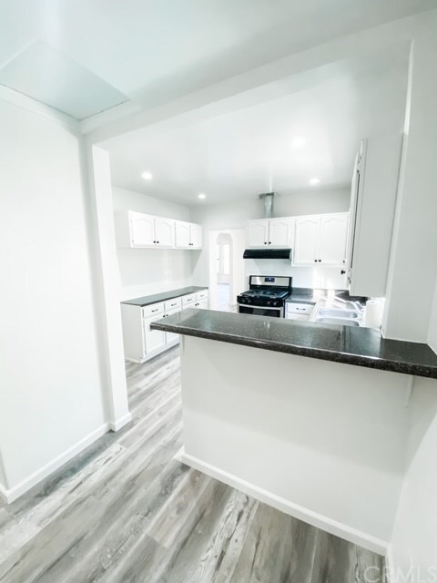
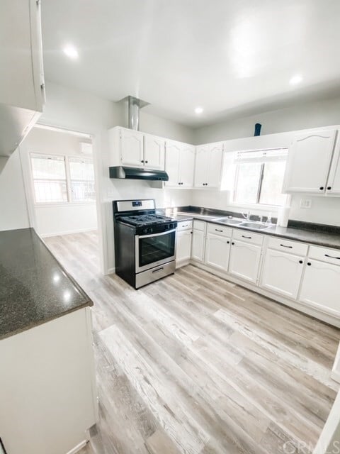
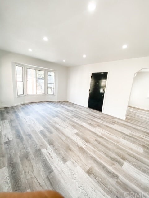
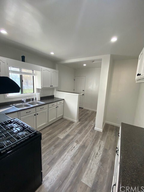
Here is your opportunity to live in the trending neighborhood of City Terrace near Keck School of Medicine, Cal State LA, Down Town L.A. and, L.A. Arts District. This rental features a remodeled 3 bedrooms/1 bathroom. New Flooring throughout, New Paint throughout, New Stove & New Air Conditioners/Heaters. Sit down, relax and look down on the street, at the neighborhood, and park from the living room bay windows as you enjoy your morning coffee. The kitchen is very functional for that aspiring chef with a window overlooking the park and neighborhood. Enjoy exercising across the street at City Terrance Park by walking, jogging, basketball, handball, and tennis. Walk to local Restaurants, Cafe's, convenience Markets, Bakery, Barbers, Laundry Mats, and public transportation. Don't forget the nearby Middle School, Robert F Kennedy Elementary. Enjoy grilling on your very own dedicated patio in the evenings and weekends that offers a view towards the park. There are 2 homes on this property detached from one another. This home is the front home for rent.
1137 Miller Ave is a house located in Los Angeles County and the 90063 ZIP Code. This area is served by the Los Angeles Unified attendance zone.
House Features
- Air Conditioning
- Heating
- Views
Location
Get Directions
Southeast Los Angeles is directly south of the Fashion District and east of the University of Southern California (USC). This large neighborhood is minutes from downtown Los Angeles, Hollywood, and Beverly Hills, with easy access to the 110 Freeway. This great location places you near sunny beaches, nature trails, and a bevy of leading employers. Students can access both USC and California State University Long Beach from their Southeast LA apartment.
This densely populated, diverse neighborhood features everything from food trucks and corner markets to wide sidewalks and residential areas filled with bungalows, ranch, and Spanish Colonial architecture. Southeast LA features palm trees and mountain views, tampered with gritty undertones to give it a cool, funky vibe.
As for outdoor fun, take your pick between Catalina Island, Venus Beach, or the Santa Monica Pier. Nearby, you’ll find more sunny beaches like White Point, Cabrillo, and Long Beach.
Learn more about living in Southeast Los AngelesBelow are rent ranges for similar nearby apartments
Amenities
- Air Conditioning
- Heating
- Views
Expenses
Utilities Included
Sewer
Included
Education
| Colleges & Universities | Distance | ||
|---|---|---|---|
| Colleges & Universities | Distance | ||
| Drive: | 4 min | 1.7 mi | |
| Drive: | 5 min | 2.3 mi | |
| Drive: | 6 min | 2.5 mi | |
| Drive: | 9 min | 6.0 mi |
1137 Miller Ave is within 4 minutes or 1.7 miles from Cal State Los Angeles. It is also near USC, Health Sciences Campus and East Los Angeles College.
Schools


Charter Elementary School
Grades K-5
75 Students
Nearby
Public Elementary School
Grades K-6
185 Students
Attendance Zone
Public Middle School
Grades 6-8
727 Students
Attendance Zone
Public High School
Grades 9-12
218 Students
Attendance Zone
Private Elementary & Middle School
Grades PK-8
245 Students
Nearby
Private Elementary, Middle & High School
Grades K-12
Nearby
Private Elementary & Middle School
Grades K-8
161 Students
Nearby
School data provided by
 The GreatSchools Rating helps parents compare schools within a state based on a variety of school quality indicators and provides a helpful picture of how effectively each school serves all of its students. Ratings are on a scale of 1 (below average) to 10 (above average) and can include test scores, college readiness, academic progress, advanced courses, equity, discipline and attendance data. We also advise parents to visit schools, consider other information on school performance and programs, and consider family needs as part of the school selection process.
View GreatSchools Rating Methodology
Data provided by GreatSchools.org © 2025. All rights reserved.
View GreatSchools Rating Methodology
Data provided by GreatSchools.org © 2025. All rights reserved.
Transportation options available in Los Angeles include Indiana, located 2.0 miles from 1137 Miller Ave. 1137 Miller Ave is near Bob Hope, located 18.7 miles or 26 minutes away, and Los Angeles International, located 20.1 miles or 32 minutes away.
| Transit / Subway | Distance | ||
|---|---|---|---|
| Transit / Subway | Distance | ||
|
|
Drive: | 4 min | 2.0 mi |
| Drive: | 4 min | 2.0 mi | |
|
|
Drive: | 5 min | 2.5 mi |
|
|
Drive: | 5 min | 2.7 mi |
|
|
Drive: | 6 min | 3.0 mi |
| Commuter Rail | Distance | ||
|---|---|---|---|
| Commuter Rail | Distance | ||
|
|
Drive: | 7 min | 4.1 mi |
|
|
Drive: | 9 min | 4.2 mi |
|
|
Drive: | 12 min | 5.6 mi |
|
|
Drive: | 12 min | 6.7 mi |
| Drive: | 10 min | 8.0 mi |
| Airports | Distance | ||
|---|---|---|---|
| Airports | Distance | ||
|
Bob Hope
|
Drive: | 26 min | 18.7 mi |
|
Los Angeles International
|
Drive: | 32 min | 20.1 mi |
Time and distance from 1137 Miller Ave.
| Shopping Centers | Distance | ||
|---|---|---|---|
| Shopping Centers | Distance | ||
| Drive: | 4 min | 1.8 mi | |
| Drive: | 4 min | 1.8 mi | |
| Drive: | 5 min | 2.2 mi |
1137 Miller Ave has 3 shopping centers within 2.2 miles, which is about a 5-minute drive. The miles and minutes will be for the farthest away property.
| Parks and Recreation | Distance | ||
|---|---|---|---|
| Parks and Recreation | Distance | ||
|
Hollenbeck Lake
|
Drive: | 7 min | 3.3 mi |
|
Audubon Center at Debs Park
|
Drive: | 11 min | 6.2 mi |
|
Elysian Park
|
Drive: | 14 min | 6.2 mi |
|
Elyria Canyon Park
|
Drive: | 13 min | 7.0 mi |
|
Chavez Ravine Arboretum
|
Drive: | 11 min | 7.1 mi |
1137 Miller Ave has 5 parks within 7.1 miles, including Hollenbeck Lake, Audubon Center at Debs Park, and Elysian Park.
| Hospitals | Distance | ||
|---|---|---|---|
| Hospitals | Distance | ||
| Drive: | 5 min | 2.4 mi | |
| Drive: | 5 min | 2.4 mi | |
| Drive: | 6 min | 2.7 mi |
1137 Miller Ave has 3 hospitals within 2.7 miles, the nearest is Keck Hospital of USC which is 2.4 miles away and a 5 minute drive.
| Military Bases | Distance | ||
|---|---|---|---|
| Military Bases | Distance | ||
| Drive: | 29 min | 21.7 mi | |
| Drive: | 34 min | 22.8 mi |
1137 Miller Ave is 21.7 miles from Los Angeles Air Force Base, and is convenient to other military bases, including Los Alamitos Army Airfield.
You May Also Like
Similar Rentals Nearby


What Are Walk Score®, Transit Score®, and Bike Score® Ratings?
Walk Score® measures the walkability of any address. Transit Score® measures access to public transit. Bike Score® measures the bikeability of any address.
What is a Sound Score Rating?
A Sound Score Rating aggregates noise caused by vehicle traffic, airplane traffic and local sources
1137 Miller Ave
Los Angeles, CA 90063