
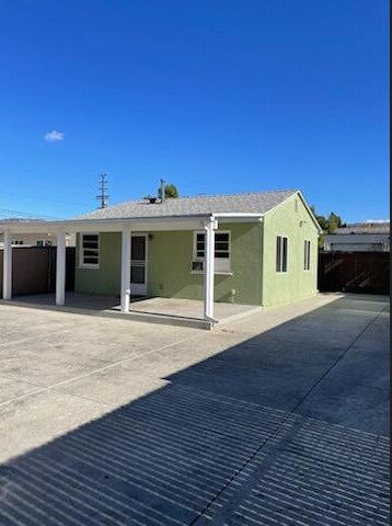
11266 Sheldon St
Sun Valley, CA 91352
-
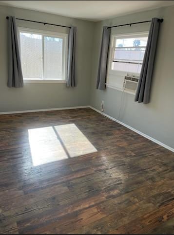
Bedrooms
1
-
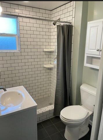
Bathrooms
1
-
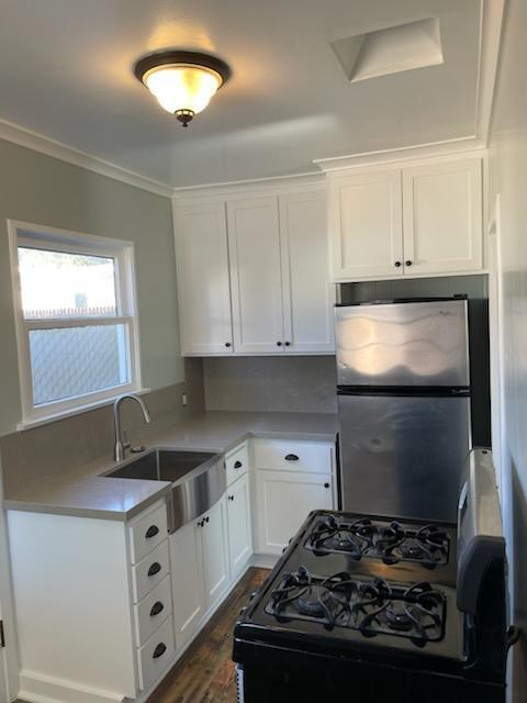
Square Feet
500 sq ft
-
Available
Available Now

Contact
- Contact
Sun Valley is a neighborhood in the San Fernando Valley section of Los Angeles, sitting at the crossroads of Highway 210 and Interstate 5 — a location that keeps it well-connected to the rest of the city without placing renters in the middle of its busiest corridors. The area carries a grounded, residential character, with a density that feels more like a self-contained community than a typical L.A. suburb. Its roots trace back to 1874, when Charles Maclay acquired tens of thousands of acres that eventually shaped the neighborhood's development into the lived-in, working district it is today.
Renters here find a mix of apartment communities, smaller multi-unit buildings, and single-family rentals spread across roughly ten square miles. Neighboring North Hollywood and Arleta offer additional housing options and commercial activity within close reach. John H.
Learn more about living in Sun Valley| Colleges & Universities | Distance | ||
|---|---|---|---|
| Colleges & Universities | Distance | ||
| Drive: | 10 min | 4.4 mi | |
| Drive: | 15 min | 6.6 mi | |
| Drive: | 12 min | 7.0 mi | |
| Drive: | 16 min | 8.3 mi |
Transportation options available in Sun Valley include North Hollywood Station, located 6.5 miles from 11266 Sheldon St. 11266 Sheldon St is near Bob Hope, located 4.9 miles or 9 minutes away, and Los Angeles International, located 29.0 miles or 44 minutes away.
| Transit / Subway | Distance | ||
|---|---|---|---|
| Transit / Subway | Distance | ||
|
|
Drive: | 11 min | 6.5 mi |
|
|
Drive: | 15 min | 8.8 mi |
| Commuter Rail | Distance | ||
|---|---|---|---|
| Commuter Rail | Distance | ||
|
|
Drive: | 6 min | 3.0 mi |
| Drive: | 8 min | 4.7 mi | |
|
|
Drive: | 11 min | 5.3 mi |
|
|
Drive: | 12 min | 6.4 mi |
|
|
Drive: | 13 min | 6.4 mi |
| Airports | Distance | ||
|---|---|---|---|
| Airports | Distance | ||
|
Bob Hope
|
Drive: | 9 min | 4.9 mi |
|
Los Angeles International
|
Drive: | 44 min | 29.0 mi |
Scores provided by
Traffic
-Airport
-Businesses
-Scores provided by
HowLoud What is a Sound Score Rating? A Sound Score Rating aggregates noise caused by vehicle traffic, airplane traffic and local sources. How It WorksTime and distance from 11266 Sheldon St.
| Shopping Centers | Distance | ||
|---|---|---|---|
| Shopping Centers | Distance | ||
| Drive: | 4 min | 1.5 mi | |
| Drive: | 4 min | 2.0 mi | |
| Drive: | 5 min | 2.5 mi |
| Parks and Recreation | Distance | ||
|---|---|---|---|
| Parks and Recreation | Distance | ||
|
La Tuna Canyon Park
|
Drive: | 10 min | 5.8 mi |
|
El Cariso Regional Park
|
Drive: | 13 min | 7.2 mi |
|
Veterans Memorial Park
|
Drive: | 17 min | 8.3 mi |
|
Wildlife Waystation
|
Drive: | 16 min | 8.9 mi |
|
Sepulveda Basin Wildlife Reserve
|
Drive: | 24 min | 12.1 mi |
| Hospitals | Distance | ||
|---|---|---|---|
| Hospitals | Distance | ||
| Drive: | 3 min | 1.5 mi | |
| Drive: | 9 min | 4.1 mi | |
| Drive: | 12 min | 6.1 mi |
| Military Bases | Distance | ||
|---|---|---|---|
| Military Bases | Distance | ||
| Drive: | 44 min | 31.6 mi | |
| Drive: | 58 min | 42.1 mi | |
| Drive: | 60 min | 45.1 mi |
11266 Sheldon St Photos
What Are Walk Score®, Transit Score®, and Bike Score® Ratings?
Walk Score® measures the walkability of any address. Transit Score® measures access to public transit. Bike Score® measures the bikeability of any address.
What is a Sound Score Rating?
A Sound Score Rating aggregates noise caused by vehicle traffic, airplane traffic and local sources.
11266 Sheldon St
Sun Valley, CA 91352