

$1,800
Total Monthly Price
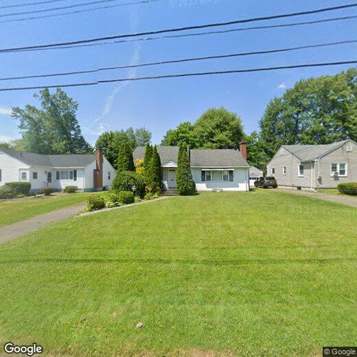
11 Sherwood Rd
West Hartford, CT 06117
Favorites
11 Sherwood Rd

Favorites
Check Back Soon for Upcoming Availability
| Beds | Baths | Average SF |
|---|---|---|
| 2 Bedrooms 2 Bedrooms 2 Br | 1.5 Baths 1.5 Baths 1.5 Ba | — |
About This Property
Great 2-Bedroom, 1&1/2-Bath RANCH available immediately for RENT in a Quiet street 1/4-mile east from Bishops Corner-close to everything. Detached garage; Central Air; Fresh paint & Hardwood floors throughout; Nice front & rear yards; Large Clean basement for ample storage. Local landlord. This Ranch boasts an open floor plan; a spacious Living room with a Fireplace; a formal Dining room; a large eaten-in Kitchen with all new/newer appliances, plenty of cabinets, counter space, a Pantry and access to the laundry area; the good size bedrooms; the updated bathrooms. A 3-season room overlooking the backyard is accessible from kitchen and offers a perfect rest area for a family in the summer. Parking is easy in the detached garage and driveway. No smoking. Pets are negotiable. Tenants are responsible for ground maintenance. Potential tenants must present credit and background reports. Security deposit is 1.5-2 mo. rents based on the reports. Rental liability insurance after signing a lease.
11 Sherwood Rd is a house located in Hartford County and the 06117 ZIP Code. This area is served by the West Hartford School District attendance zone.
11 Sherwood Rd,
West Hartford,
CT
06117
Set five miles west of Connecticut's state capital, West Hartford carries the ease of a walkable town with the economic pull of a major metro close by. The University of Hartford and the University of Saint Joseph both anchor the town, lending it a steady academic presence alongside the government, insurance, and healthcare sectors concentrated in Hartford. West Hartford Center, built around Farmington Avenue and Main Street, has served as the commercial core since the late 17th century and still draws people with its mix of independent shops, theaters, and outdoor dining. Neighborhoods like Elmwood, Bishops Corner, and the Asylum Avenue corridor each have their own character, from tree-lined residential streets to areas with quick highway and transit access. Elizabeth Park, home to the oldest public rose garden in the country, sits on the town's northeastern edge and anchors an active outdoor scene year-round.
Learn more about living in West Hartford
Education
| Colleges & Universities | Distance | ||
|---|---|---|---|
| Colleges & Universities | Distance | ||
| Walk: | 7 min | 0.4 mi | |
| Drive: | 5 min | 2.4 mi | |
| Drive: | 4 min | 2.7 mi | |
| Drive: | 8 min | 5.3 mi |
11 Sherwood Rd is within 7 minutes or 0.4 mile from UCONN, Tri Campus, Hartford. It is also near University of Hartford and University of Connecticut.
Schools


Public Elementary School
Grades PK-5
415 Students
Attendance Zone
Public Middle School
Grades 6-8
815 Students
Attendance Zone
Public High School
Grades 9-12
1,408 Students
Attendance Zone
Private Elementary & Middle School
Grades PK-8
172 Students
Nearby
Private Elementary, Middle & High School
Grades K-12
138 Students
Nearby
School data provided by
 The GreatSchools Rating helps parents compare schools within a state based on a variety of school quality indicators and provides a helpful picture of how effectively each school serves all of its students. Ratings are on a scale of 1 (below average) to 10 (above average) and can include test scores, college readiness, academic progress, advanced courses, equity, discipline and attendance data. We also advise parents to visit schools, consider other information on school performance and programs, and consider family needs as part of the school selection process.
View GreatSchools Rating Methodology
Data provided by GreatSchools.org © 2026. All rights reserved.
View GreatSchools Rating Methodology
Data provided by GreatSchools.org © 2026. All rights reserved.
Walkability Near 11 Sherwood Rd West Hartford, CT 06117
Getting Around
 What do Walkability, Transit, Drivability, and Bikeability mean?
Walkability measures the walking distance to day-to-day needs.
Transit measures access to public transportation.
Drivability measures congestion, parking availability, and access to major roads.
Bikeability measures the suitability for cycling.
How It Works
What do Walkability, Transit, Drivability, and Bikeability mean?
Walkability measures the walking distance to day-to-day needs.
Transit measures access to public transportation.
Drivability measures congestion, parking availability, and access to major roads.
Bikeability measures the suitability for cycling.
How It Works
Fairly Walkable
Walkability
40
/ 100
Limited Public Transit
Transit
30
/ 100
Exceptionally Drivable
Drivability
100
/ 100
Fairly Bikeable
Bikeability
50
/ 100
Scores provided by
-
Soundscore™
-
/ 100
Traffic
-Airport
-Businesses
-Scores provided by
HowLoud What is a Sound Score Rating? A Sound Score Rating aggregates noise caused by vehicle traffic, airplane traffic and local sources. How It WorksYou May Also Like
Similar Rentals Nearby
-
-

-

-

-
 6 Beds, 7 Baths, 10,157 sq ft$35,000Total Monthly PriceTotal Monthly Price NewPrices include all required monthly fees.55 Bishop Ln
 -
 5 Beds, 6 Baths, 4,626 sq ft$8,000Total Monthly PriceTotal Monthly Price NewPrices include all required monthly fees.3 Eton Pl
 -
 2 Beds, 1 Bath, 1,523 sq ft$1,800Total Monthly PriceTotal Monthly Price NewPrices include all required monthly fees.103 Capen St
 -
 3 Beds, 1 Bath, 2,652 sq ft$1,750Total Monthly PriceTotal Monthly Price NewPrices include all required monthly fees.119 Carroll St
 -
 3 Beds, 2 Baths, 1,600 sq ft$2,500Total Monthly PriceTotal Monthly Price NewPrices include all required monthly fees.61 Arch St
 -
 4 Beds, 5 Baths, 2,850 sq ft$6,500Total Monthly PriceTotal Monthly Price NewPrices include all required monthly fees.6 Fennwood Dr
What Are Walk Score®, Transit Score®, and Bike Score® Ratings?
Walk Score® measures the walkability of any address. Transit Score® measures access to public transit. Bike Score® measures the bikeability of any address.
What is a Sound Score Rating?
A Sound Score Rating aggregates noise caused by vehicle traffic, airplane traffic and local sources.
11 Sherwood Rd
West Hartford, CT 06117