$2,120 / Month
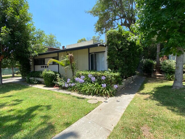
1091 N Los Robles Ave Unit 5
Pasadena, CA 91104
2 Weeks Ago
Favorites
1091 N Los Robles Ave Unit 5

Favorites
Check Back Soon for Upcoming Availability
| Beds | Baths | Average SF |
|---|---|---|
| 2 Bedrooms 2 Bedrooms 2 Br | 1 Bath 1 Bath 1 Ba | 700 SF |
Fees and Policies
The fees below are based on community-supplied data and may exclude additional fees and utilities.
- Dogs Allowed
-
Fees not specified
- Cats Allowed
-
Fees not specified
- Parking
-
Other--
Details
Utilities Included
-
Water
-
Trash Removal
-
Sewer
Property Information
-
20 units
About This Property
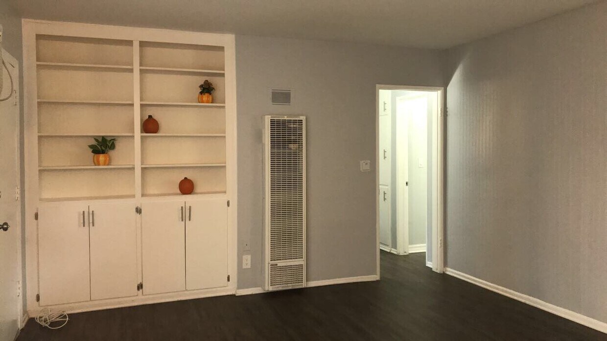
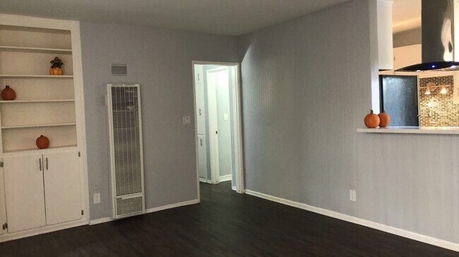
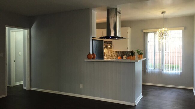
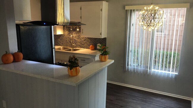
**OPEN HOUSE!!! FRIDAY, AUGUST 5TH, 11:00 AM TO 12:15 PM** This great 2nd floor apartment is located on a tree-lined street in Pasadena. Easy access to stores, restaurants, Colorado Blvd, freeways, and the best Pasadena has to offer. A courtyard for entertaining and relaxing. Property Features: -Carport -On-site laundry -Great Location -Lush landscaping with mature trees Apartment Features: -Recently updated -Hard-surface flooring throughout -Custom paint scheme -Classic fixtures and lighting -Stove and refrigerator Near By: -Pasadena Convention Center -Golf Course -Parks -Pasadena Museum of California Art -Pasadena Public Library -Minutes to Mount Wilson Small pets under 30 lbs allowed. Qualifications needed: -Minimum total household income of $69,000+ per year. -Good credit (no collections). -No bankruptcies, evictions, or unlawful detainers. -No criminal record. *Pictures may be of a different unit, some paint schemes and fixtures may be different in actual unit.
1091 N Los Robles Ave is an apartment community located in Los Angeles County and the 91104 ZIP Code.
Apartment Features
- Air Conditioning
- Refrigerator
- Laundry Facilities
- Courtyard
Location
Get Directions
Near the San Gabriel Mountains, where I-210 meets State Route 134 and becomes the Foothill Freeway, rests Pasadena’s Garfield Heights neighborhood. Primarily a residential area, Garfield Heights contains a number of markets, churches, and temples. Garfield Heights residents enjoy access to neighboring parks such as La Pintoresca Park and City of Pasadena Robinson Park.
There are a host of amenities located within close proximity to Garfield Heights. Among the many amenities are the Rose Bowl Stadium, Kidspace Children’s Museum, Norton Simon Museum, Brookside Golf and Country Club, Pasadena Convention Center, Paseo Colorado, and the California Institute of Technology.
Served by several Metro Local lines and Pasadena Transit routes, getting around Garfield Height is a breeze.
Learn more about living in Garfield HeightsBelow are rent ranges for similar nearby apartments
Amenities
- Air Conditioning
- Refrigerator
- Laundry Facilities
- Courtyard
Expenses
Utilities Included
Water, Trash Removal, Sewer
Included
Education
| Colleges & Universities | Distance | ||
|---|---|---|---|
| Colleges & Universities | Distance | ||
| Drive: | 3 min | 1.3 mi | |
| Drive: | 6 min | 2.7 mi | |
| Drive: | 7 min | 3.0 mi | |
| Drive: | 10 min | 3.8 mi |
1091 N Los Robles Ave Unit 5 is within 3 minutes or 1.3 miles from Fuller Theological Seminary. It is also near Pasadena City College and Caltech.
Transportation options available in Pasadena include Memorial Park Station, located 1.6 miles from 1091 N Los Robles Ave Unit 5. 1091 N Los Robles Ave Unit 5 is near Bob Hope, located 17.6 miles or 24 minutes away, and Los Angeles International, located 26.4 miles or 42 minutes away.
| Transit / Subway | Distance | ||
|---|---|---|---|
| Transit / Subway | Distance | ||
|
|
Drive: | 4 min | 1.6 mi |
|
|
Drive: | 5 min | 2.0 mi |
|
|
Drive: | 4 min | 2.1 mi |
|
|
Drive: | 4 min | 2.5 mi |
|
|
Drive: | 6 min | 2.8 mi |
| Commuter Rail | Distance | ||
|---|---|---|---|
| Commuter Rail | Distance | ||
|
|
Drive: | 14 min | 10.1 mi |
|
|
Drive: | 19 min | 11.3 mi |
|
|
Drive: | 21 min | 11.4 mi |
|
|
Drive: | 21 min | 11.5 mi |
| Drive: | 23 min | 15.4 mi |
| Airports | Distance | ||
|---|---|---|---|
| Airports | Distance | ||
|
Bob Hope
|
Drive: | 24 min | 17.6 mi |
|
Los Angeles International
|
Drive: | 42 min | 26.4 mi |
Time and distance from 1091 N Los Robles Ave Unit 5.
| Shopping Centers | Distance | ||
|---|---|---|---|
| Shopping Centers | Distance | ||
| Walk: | 9 min | 0.5 mi | |
| Walk: | 13 min | 0.7 mi | |
| Walk: | 16 min | 0.9 mi |
1091 N Los Robles Ave Unit 5 has 3 shopping centers within 0.9 mile, which is about a 16-minute walk. The miles and minutes will be for the farthest away property.
| Parks and Recreation | Distance | ||
|---|---|---|---|
| Parks and Recreation | Distance | ||
|
Kidspace Children's Museum
|
Drive: | 5 min | 2.1 mi |
|
Jet Propulsion Laboratory
|
Drive: | 6 min | 2.9 mi |
|
Eaton Canyon Nature Center
|
Drive: | 8 min | 3.6 mi |
|
Huntington Botanical Gardens
|
Drive: | 10 min | 4.1 mi |
|
Descanso Gardens
|
Drive: | 11 min | 6.3 mi |
1091 N Los Robles Ave Unit 5 has 5 parks within 6.3 miles, including Kidspace Children's Museum, Jet Propulsion Laboratory, and Eaton Canyon Nature Center.
| Hospitals | Distance | ||
|---|---|---|---|
| Hospitals | Distance | ||
| Drive: | 5 min | 2.6 mi | |
| Drive: | 8 min | 4.5 mi | |
| Drive: | 12 min | 5.9 mi |
1091 N Los Robles Ave Unit 5 has 3 hospitals within 5.9 miles, the nearest is Huntington Memorial Hospital which is 2.6 miles away and a 5 minute drive.
| Military Bases | Distance | ||
|---|---|---|---|
| Military Bases | Distance | ||
| Drive: | 39 min | 27.9 mi | |
| Drive: | 48 min | 31.2 mi |
1091 N Los Robles Ave Unit 5 is 27.9 miles from Los Angeles Air Force Base, and is convenient to other military bases, including Los Alamitos Army Airfield.
You May Also Like
Similar Rentals Nearby


What Are Walk Score®, Transit Score®, and Bike Score® Ratings?
Walk Score® measures the walkability of any address. Transit Score® measures access to public transit. Bike Score® measures the bikeability of any address.
What is a Sound Score Rating?
A Sound Score Rating aggregates noise caused by vehicle traffic, airplane traffic and local sources

1091 N Los Robles Ave
Pasadena, CA 91104