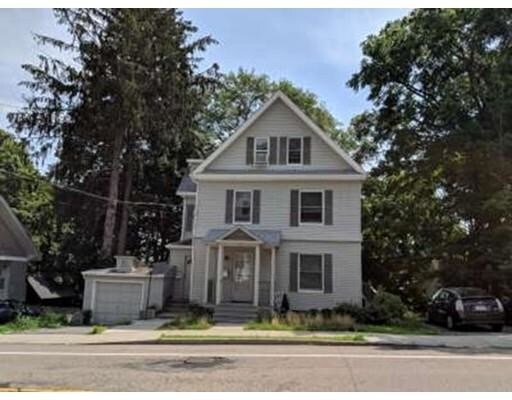

107 Dennison Ave Unit 1A
107 Dennison Ave Unit 1A
Framingham, MA 01702
2 Weeks Ago
|
Edit
Favorites
107 Dennison Ave Unit 1A

Favorites
Check Back Soon for Upcoming Availability
| Beds | Baths | Average SF |
|---|---|---|
| 1 Bedroom 1 Bedroom 1 Br | 1 Bath 1 Bath 1 Ba | 800 SF |
Fees and Policies
The fees listed below are community-provided and may exclude utilities or add-ons. All payments are made directly to the property and are non-refundable unless otherwise specified.
Details
Utilities Included
-
Water
-
Electricity
-
Heat
-
Sewer
About This Property
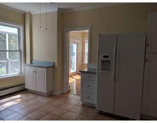
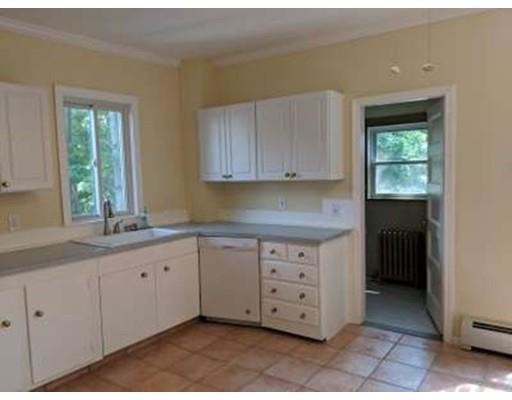
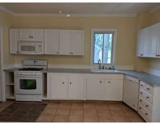
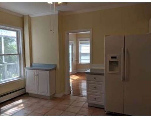
Large 1 bedroom on first floor of 3 unit building. Hardwood floors throughout. Large eat in kitchen with dishwasher, refrigerator, gas cooking and microwave. Living room has decorative fireplace. Small deck out back with views of Gleason Pond. 1 car parking. Sorry, no pets. Heat, hot water AND electric included. First, security and 1/2 month realtor fee required upfront. Washer/dryer in basement - not coin op but shared with other units. Great location near Route 9 and easy access to Route 30, Route 90, 135 and the Malls
107 Dennison Ave is a condo located in Middlesex County and the 01702 ZIP Code. This area is served by the Framingham School District attendance zone.
Condo Features
Dishwasher
Microwave
Refrigerator
Fireplace
- Cable Ready
- Fireplace
- Dishwasher
- Microwave
- Range
- Refrigerator
- Deck
107 Dennison Ave,
Framingham,
MA
01702
Just west of Boston and East of Worcester sits Metro West, a region that houses a group of towns and cities with significant historical backgrounds. A total of 19 municipalities make up the core of this community, but other municipalities are considered to be a part of the Interstate 495/Metro West Corridor.
Learn more about living in Metro WestBelow are rent ranges for similar nearby apartments
| Beds | Average Size | Lowest | Typical | Premium |
|---|---|---|---|---|
| Studio Studio Studio | 524-526 Sq Ft | $1,000 | $2,316 | $7,159 |
| 1 Bed 1 Bed 1 Bed | 840-842 Sq Ft | $1,500 | $2,737 | $10,700 |
| 2 Beds 2 Beds 2 Beds | 1181-1183 Sq Ft | $1,700 | $3,457 | $15,205 |
| 3 Beds 3 Beds 3 Beds | 1550-1553 Sq Ft | $2,450 | $4,794 | $18,517 |
| 4 Beds 4 Beds 4 Beds | 3422 Sq Ft | $1,110 | $6,603 | $32,681 |
Amenities
- Cable Ready
- Fireplace
- Dishwasher
- Microwave
- Range
- Refrigerator
- Deck
Expenses
Utilities Included
Water, Electricity, Heat, Sewer
Included
Education
| Colleges & Universities | Distance | ||
|---|---|---|---|
| Colleges & Universities | Distance | ||
| Drive: | 5 min | 2.1 mi | |
| Drive: | 16 min | 6.8 mi | |
| Drive: | 17 min | 9.0 mi | |
| Drive: | 22 min | 12.3 mi |
107 Dennison Ave Unit 1A is within 5 minutes or 2.1 miles from Framingham State College. It is also near Wellesley College and Babson College.
Schools


Public High School
Grades PK & 9-12
1,753 Students
Nearby
Public Elementary School
Grades K-5
480 Students
Nearby
Public Middle School
Grades 6-8
315 Students
Nearby
Public High School
Grades 9-12
2,271 Students
Attendance Zone
Private Elementary & Middle School
Grades PK-8
174 Students
Nearby
Private High School
Grades 9-12
227 Students
Nearby
School data provided by
 The GreatSchools Rating helps parents compare schools within a state based on a variety of school quality indicators and provides a helpful picture of how effectively each school serves all of its students. Ratings are on a scale of 1 (below average) to 10 (above average) and can include test scores, college readiness, academic progress, advanced courses, equity, discipline and attendance data. We also advise parents to visit schools, consider other information on school performance and programs, and consider family needs as part of the school selection process.
View GreatSchools Rating Methodology
Data provided by GreatSchools.org © 2026. All rights reserved.
View GreatSchools Rating Methodology
Data provided by GreatSchools.org © 2026. All rights reserved.
Transportation options available in Framingham include Woodland Station, located 10.4 miles from 107 Dennison Ave Unit 1A. 107 Dennison Ave Unit 1A is near General Edward Lawrence Logan International, located 24.4 miles or 37 minutes away, and Worcester Regional, located 26.1 miles or 45 minutes away.
| Transit / Subway | Distance | ||
|---|---|---|---|
| Transit / Subway | Distance | ||
|
|
Drive: | 18 min | 10.4 mi |
|
|
Drive: | 20 min | 11.1 mi |
|
|
Drive: | 19 min | 11.3 mi |
| Commuter Rail | Distance | ||
|---|---|---|---|
| Commuter Rail | Distance | ||
|
|
Walk: | 19 min | 1.0 mi |
|
|
Walk: | 21 min | 1.1 mi |
|
|
Drive: | 5 min | 1.9 mi |
|
|
Drive: | 9 min | 4.3 mi |
|
|
Drive: | 16 min | 5.4 mi |
| Airports | Distance | ||
|---|---|---|---|
| Airports | Distance | ||
|
General Edward Lawrence Logan International
|
Drive: | 37 min | 24.4 mi |
|
Worcester Regional
|
Drive: | 45 min | 26.1 mi |
Walkability Near 107 Dennison Ave Framingham, MA 01702
Getting Around
 What do Walkability, Transit, Drivability, and Bikeability mean?
Walkability measures the walking distance to day-to-day needs.
Transit measures access to public transportation.
Drivability measures congestion, parking availability, and access to major roads.
Bikeability measures the suitability for cycling.
How It Works
What do Walkability, Transit, Drivability, and Bikeability mean?
Walkability measures the walking distance to day-to-day needs.
Transit measures access to public transportation.
Drivability measures congestion, parking availability, and access to major roads.
Bikeability measures the suitability for cycling.
How It Works
Moderately Walkable
Walkability
60
/ 100
Limited Public Transit
Transit
30
/ 100
Exceptionally Drivable
Drivability
100
/ 100
Fairly Bikeable
Bikeability
40
/ 100
Scores provided by
-
Soundscore™
-
/ 100
Traffic
-Airport
-Businesses
-Scores provided by
HowLoud What is a Sound Score Rating? A Sound Score Rating aggregates noise caused by vehicle traffic, airplane traffic and local sources. How It WorksTime and distance from 107 Dennison Ave Unit 1A.
| Shopping Centers | Distance | ||
|---|---|---|---|
| Shopping Centers | Distance | ||
| Walk: | 13 min | 0.7 mi | |
| Walk: | 21 min | 1.1 mi | |
| Drive: | 3 min | 1.3 mi |
107 Dennison Ave Unit 1A has 3 shopping centers within 1.3 miles, which is about a 3-minute drive. The miles and minutes will be for the farthest away property.
| Parks and Recreation | Distance | ||
|---|---|---|---|
| Parks and Recreation | Distance | ||
|
Callahan State Park
|
Drive: | 8 min | 4.2 mi |
|
Cowassock Woods and Ashland Town Forest
|
Drive: | 10 min | 4.3 mi |
|
Hop Brook Natural Area
|
Drive: | 9 min | 4.4 mi |
|
Garden in the Woods
|
Drive: | 12 min | 5.6 mi |
|
Cochituate State Park
|
Drive: | 18 min | 10.7 mi |
107 Dennison Ave Unit 1A has 5 parks within 10.7 miles, including Cochituate State Park, Callahan State Park, and Cowassock Woods and Ashland Town Forest.
| Hospitals | Distance | ||
|---|---|---|---|
| Hospitals | Distance | ||
| Walk: | 14 min | 0.7 mi | |
| Drive: | 20 min | 10.8 mi | |
| Drive: | 19 min | 10.9 mi |
107 Dennison Ave Unit 1A has 3 hospitals within 10.9 miles, the nearest is MetroWest Medical Center which is 0.7 mile away and a 14 minute walk.
| Military Bases | Distance | ||
|---|---|---|---|
| Military Bases | Distance | ||
| Drive: | 9 min | 4.5 mi | |
| Drive: | 33 min | 16.9 mi |
107 Dennison Ave Unit 1A is 4.5 miles from US Military Reservation, and is convenient to other military bases, including Hanscom Air Force Base.
You May Also Like
Similar Rentals Nearby


What Are Walk Score®, Transit Score®, and Bike Score® Ratings?
Walk Score® measures the walkability of any address. Transit Score® measures access to public transit. Bike Score® measures the bikeability of any address.
What is a Sound Score Rating?
A Sound Score Rating aggregates noise caused by vehicle traffic, airplane traffic and local sources.

107 Dennison Ave
Framingham, MA 01702