
Venue Residences
3688 Overland Ave,
Los Angeles, CA 90034
$2,695 - $5,995
Studio - 2 Beds

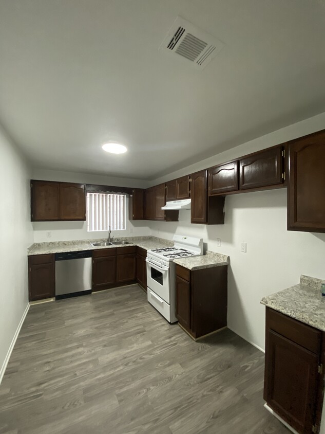
Don't miss this fantastic opportunity to rent this cozy lower level 2 bedroom 1 bath. Kitchen has an open layout that comes equipped with a stove, stainless steel dishwasher, plenty of cabinet space. This property also offers a large parking area, giving you plenty of space for all your parking needs. No onsite laundry room or pool. Tenant pays all utilities except water and trash. Credit requirement is 650 with an income 2 times the rent.
10617 S Main St is an apartment community located in Los Angeles County and the 90003 ZIP Code. This area is served by the Los Angeles Unified Rocp School District attendance zone.
Dishwasher
Disposal
Stainless Steel Appliances
Smoke Free
Bounded by Interstate 110 to the west, Canndu/Avalon Gardens is a buzzing residential community approximately eight miles south of Downtown Los Angeles. Along the way, you’ll pass Exposition Park, the Natural Historic Museum of Los Angeles County, and the University of Southern California. This area sits near Huntington Park and provides renters with affordable housing options, a quick commute into the heart of the city, and walkable avenues. A variety of public schools, small businesses, retailers, and conveniences are spread throughout the area, but Canndu/Avalon Gardens is mainly residential. Apartments, houses, condos, and townhomes are available for rent and range from affordable to upscale, so there’s something for everyone.
Learn more about living in Canndu/Avalon GardensCompare neighborhood and city base rent averages by bedroom.
| Canndu/Avalon Gardens | Los Angeles, CA | |
|---|---|---|
| Studio | $1,168 | $1,708 |
| 1 Bedroom | $937 | $2,181 |
| 2 Bedrooms | $1,318 | $3,008 |
| 3 Bedrooms | $1,739 | $4,290 |
| Colleges & Universities | Distance | ||
|---|---|---|---|
| Colleges & Universities | Distance | ||
| Drive: | 7 min | 2.8 mi | |
| Drive: | 11 min | 6.7 mi | |
| Drive: | 13 min | 6.8 mi | |
| Drive: | 11 min | 7.2 mi |


Transportation options available in Los Angeles include Harbor Fwy Station, located 1.3 miles from 10617 S Main St. 10617 S Main St is near Los Angeles International, located 10.0 miles or 16 minutes away, and Long Beach (Daugherty Field), located 15.0 miles or 22 minutes away.
| Transit / Subway | Distance | ||
|---|---|---|---|
| Transit / Subway | Distance | ||
|
|
Drive: | 2 min | 1.3 mi |
|
|
Drive: | 2 min | 1.4 mi |
|
|
Drive: | 3 min | 1.9 mi |
|
|
Drive: | 4 min | 2.4 mi |
|
|
Drive: | 4 min | 3.0 mi |
| Commuter Rail | Distance | ||
|---|---|---|---|
| Commuter Rail | Distance | ||
|
|
Drive: | 14 min | 10.4 mi |
|
|
Drive: | 16 min | 10.6 mi |
|
|
Drive: | 21 min | 12.6 mi |
|
|
Drive: | 23 min | 14.1 mi |
| Drive: | 18 min | 14.4 mi |
| Airports | Distance | ||
|---|---|---|---|
| Airports | Distance | ||
|
Los Angeles International
|
Drive: | 16 min | 10.0 mi |
|
Long Beach (Daugherty Field)
|
Drive: | 22 min | 15.0 mi |
Scores provided by
Traffic
-Airport
-Businesses
-Scores provided by
HowLoud What is a Sound Score Rating? A Sound Score Rating aggregates noise caused by vehicle traffic, airplane traffic and local sources. How It WorksTime and distance from 10617 S Main St.
| Shopping Centers | Distance | ||
|---|---|---|---|
| Shopping Centers | Distance | ||
| Drive: | 2 min | 1.2 mi | |
| Drive: | 2 min | 1.3 mi | |
| Drive: | 3 min | 1.5 mi |
| Parks and Recreation | Distance | ||
|---|---|---|---|
| Parks and Recreation | Distance | ||
|
Watts Towers-Rodia State Park
|
Drive: | 5 min | 2.2 mi |
|
Watts Senior Center & Rose Garden
|
Drive: | 4 min | 2.2 mi |
|
Compton Creek Natural Park at George Washington Elementary
|
Drive: | 8 min | 4.6 mi |
|
Augustus Hawkins Natural Park
|
Drive: | 8 min | 5.7 mi |
|
California Science Center
|
Drive: | 9 min | 5.9 mi |
| Hospitals | Distance | ||
|---|---|---|---|
| Hospitals | Distance | ||
| Drive: | 5 min | 2.8 mi | |
| Drive: | 6 min | 4.4 mi | |
| Drive: | 8 min | 4.8 mi |
| Military Bases | Distance | ||
|---|---|---|---|
| Military Bases | Distance | ||
| Drive: | 13 min | 8.3 mi | |
| Drive: | 24 min | 16.8 mi | |
| Drive: | 27 min | 19.1 mi |
What Are Walk Score®, Transit Score®, and Bike Score® Ratings?
Walk Score® measures the walkability of any address. Transit Score® measures access to public transit. Bike Score® measures the bikeability of any address.
What is a Sound Score Rating?
A Sound Score Rating aggregates noise caused by vehicle traffic, airplane traffic and local sources.
10617 S Main St
Los Angeles, CA 90003


