$3,300
/ Month
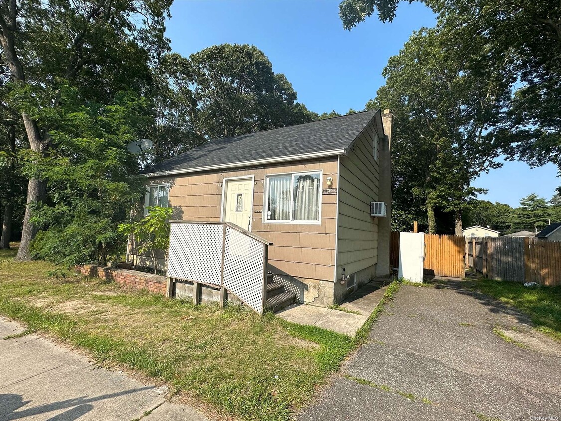
1060 William Floyd Pkwy
Shirley, NY 11967
2 Weeks Ago
|
Edit
Favorites
1060 William Floyd Pkwy

Favorites
Check Back Soon for Upcoming Availability
| Beds | Baths | Average SF |
|---|---|---|
| 2 Bedrooms 2 Bedrooms 2 Br | 1 Bath 1 Bath 1 Ba | — |
About This Property
2 bedroom cape,centrally located to major highways and shops. Based on information submitted to the MLS GRID as of [see last changed date above]. All data is obtained from various sources and may not have been verified by broker or MLS GRID. Supplied Open House Information is subject to change without notice. All information should be independently reviewed and verified for accuracy. Properties may or may not be listed by the office/agent presenting the information. Some IDX listings have been excluded from this website. Prices displayed on all Sold listings are the Last Known Listing Price and may not be the actual selling price.
1060 William Floyd Pkwy is a house located in Suffolk County and the 11967 ZIP Code. This area is served by the William Floyd Union Free School District attendance zone.
1060 William Floyd Pkwy,
Shirley,
NY
11967
Nestled on the South Shore of Long Island, Shirley is a peaceful hamlet lush with natural beauty. Residents enjoy the best of rural and suburban living in Shirley, boasting vast stretches of green space along with a slew of national retailers and chain restaurants largely clustered on Montauk Highway and William Floyd Parkway.
Residents delight in their surrounding environment’s beauty at expansive parks like Smith Point Park and Wertheim National Wildlife Refuge. Convenience to the Montauk Branch of the Long Island Rail Road, as well as the Sunrise Highway and Long Island Expressway, connects Shirley to NYC and all that Long Island has to offer.
Learn more about living in ShirleyBelow are rent ranges for similar nearby apartments
Education
| Colleges & Universities | Distance | ||
|---|---|---|---|
| Colleges & Universities | Distance | ||
| Drive: | 16 min | 10.2 mi | |
| Drive: | 22 min | 13.7 mi | |
| Drive: | 23 min | 13.8 mi | |
| Drive: | 31 min | 20.5 mi |
1060 William Floyd Pkwy is within 16 minutes or 10.2 miles from St Joseph's Coll., Long Island. It is also near SUNY Suffolk Co., Ammerman and SUNY Suffolk Co., Eastern.
Schools


Public Elementary School
Grades PK-5
515 Students
Nearby
Public Elementary School
Grades K-5
757 Students
Attendance Zone
Public Middle School
Grades 6-8
1,124 Students
Attendance Zone
Public High School
Grades 9-12
3,107 Students
Attendance Zone
Private Elementary, Middle & High School
Grades PK-12
60 Students
Nearby
Private Elementary, Middle & High School
Grades PK-12
106 Students
Nearby
Private Elementary & Middle School
Grades PK-8
184 Students
Nearby
School data provided by
 The GreatSchools Rating helps parents compare schools within a state based on a variety of school quality indicators and provides a helpful picture of how effectively each school serves all of its students. Ratings are on a scale of 1 (below average) to 10 (above average) and can include test scores, college readiness, academic progress, advanced courses, equity, discipline and attendance data. We also advise parents to visit schools, consider other information on school performance and programs, and consider family needs as part of the school selection process.
View GreatSchools Rating Methodology
Data provided by GreatSchools.org © 2026. All rights reserved.
View GreatSchools Rating Methodology
Data provided by GreatSchools.org © 2026. All rights reserved.
Walkability Near 1060 William Floyd Pkwy Shirley, NY 11967
Getting Around
 What do Walkability, Transit, Drivability, and Bikeability mean?
Walkability measures the walking distance to day-to-day needs.
Transit measures access to public transportation.
Drivability measures congestion, parking availability, and access to major roads.
Bikeability measures the suitability for cycling.
How It Works
What do Walkability, Transit, Drivability, and Bikeability mean?
Walkability measures the walking distance to day-to-day needs.
Transit measures access to public transportation.
Drivability measures congestion, parking availability, and access to major roads.
Bikeability measures the suitability for cycling.
How It Works
Fairly Walkable
Walkability
50
/ 100
Limited Public Transit
Transit
30
/ 100
Exceptionally Drivable
Drivability
100
/ 100
Fairly Bikeable
Bikeability
40
/ 100
Scores provided by
-
Soundscore™
-
/ 100
Traffic
-Airport
-Businesses
-Scores provided by
HowLoud What is a Sound Score Rating? A Sound Score Rating aggregates noise caused by vehicle traffic, airplane traffic and local sources. How It WorksYou May Also Like
Similar Rentals Nearby
-

-
 3 Beds, 2 Baths, 1,200 sq ft$3,500Total Monthly PriceTotal Monthly Price NewPrices include all required monthly fees.215 E Lakewood St
 -
 4 Beds, 3 Baths, 2,376 sq ft$35,000Total Monthly PriceTotal Monthly Price NewPrices include all required monthly fees.19 Rogers Ln
 -
 6 Beds, 3 Baths, 3,035 sq ft$45,000Total Monthly PriceTotal Monthly Price NewPrices include all required monthly fees.24 N Quarter Rd
 -
 3 Beds, 2 Baths, 2,000 sq ft$40,000Total Monthly PriceTotal Monthly Price NewPrices include all required monthly fees.31 Liberty St
 -
 3 Beds, 1 Bath, 940 sq ft$4,250Total Monthly PriceTotal Monthly Price NewPrices include all required monthly fees.5 Birch Ct
 -
 4 Beds, 3 Baths, 2,222 sq ft$4,800Total Monthly PriceTotal Monthly Price NewPrices include all required monthly fees.3 Thornridge Ln
 -
 2 Beds, 2 Baths, 918 sq ft$3,750Total Monthly PriceTotal Monthly Price NewPrices include all required monthly fees.109 Roosevelt Ave
 -
 4 Beds, 3 Baths, 1,823 sq ft$20,000Total Monthly PriceTotal Monthly Price NewPrices include all required monthly fees.9 Ocame Ave
 -
 6 Beds, 5 Baths, 3,500 sq ft$35,000Total Monthly PriceTotal Monthly Price NewPrices include all required monthly fees.38 Pheasant Run
What Are Walk Score®, Transit Score®, and Bike Score® Ratings?
Walk Score® measures the walkability of any address. Transit Score® measures access to public transit. Bike Score® measures the bikeability of any address.
What is a Sound Score Rating?
A Sound Score Rating aggregates noise caused by vehicle traffic, airplane traffic and local sources.

1060 William Floyd Pkwy
Shirley, NY 11967