

$4,300
/ Month
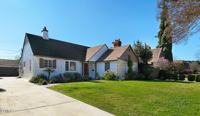
1060 W Roses Rd
San Gabriel, CA 91775
2 Weeks Ago
Favorites
1060 W Roses Rd

Favorites
Check Back Soon for Upcoming Availability
| Beds | Baths | Average SF |
|---|---|---|
| 3 Bedrooms 3 Bedrooms 3 Br | 3 Baths 3 Baths 3 Ba | 1,689 SF |
About This Property
Charming, updated single level home in North San Gabriel, located on a cul-de-sac and adjacent to San Marino. Features include a recently remodeled kitchen with LG appliances, separate prep area with sink, quartz countertops, recessed lighting, and refinished hardwood floors. Living room has a fireplace, built in bookshelves, redwood beams, and original windows. Sunny Dining Room has wainscoting, crown molding and bay window overlooking the front. Three en suite bedrooms have remodeled baths and generous closets, with one bedroom opening to a sunroom to access to the backyard. The Master suite features a walk in closet with built in cabinets and gorgeous Master bath with dual vanities, soaking tub, and separate shower. Serene backyard is private and fenced with fruit trees, custom pavers and landscaping maintained by the landlord. Excellent location, just blocks to Coolidge Elementary, and convenient to area restaurants, markets, and recreation.
1060 W Roses Rd is a house located in Los Angeles County and the 91775 ZIP Code. This area is served by the San Gabriel Unified attendance zone.
House Features
- Heating
- Fireplace
- Tile Floors
- Patio
Location
Get Directions
Situated about ten miles northeast of Los Angeles, San Gabriel is a scenic suburb often regarded as the “Birthplace of the Los Angeles Region.” The city boasts a rich history dating back to the 1700s, when the Mission San Gabriel (known as the “Pride of the California Missions”) was founded.
San Gabriel’s historic roots are on display to this day, with the vibrant Mission District serving as the city’s hub of culture, art, and history. City Hall, the San Gabriel Mission Playhouse, and numerous well-maintained Spanish Colonial Revival style buildings are the cornerstones of the District. A host of diverse eateries, cafes, offices, shops, and museums—including the famed San Gabriel Mission—are also found in this vibrant downtown area.
Area residents enjoy a bevy of outdoor activities at Vincent Lugo Park, Smith Park, and San Gabriel Country Club.
Learn more about living in San Gabriel
Amenities
- Heating
- Fireplace
- Tile Floors
- Patio
Education
| Colleges & Universities | Distance | ||
|---|---|---|---|
| Colleges & Universities | Distance | ||
| Drive: | 8 min | 2.9 mi | |
| Drive: | 9 min | 3.4 mi | |
| Drive: | 9 min | 3.7 mi | |
| Drive: | 10 min | 4.1 mi |
1060 W Roses Rd is within 9 minutes or 3.4 miles from Caltech. It is also near Art Center College of Design and Pasadena City College.
Schools


Public Elementary School
Grades K-6
454 Students
Nearby
Public Elementary School
Grades K-5
274 Students
Attendance Zone
Public Middle School
Grades 6-8
927 Students
Attendance Zone
Public High School
Grades 9-12
1,527 Students
Attendance Zone
Private Elementary & Middle School
Grades K-8
178 Students
Nearby
Private Elementary, Middle & High School
Grades 1-12
100 Students
Nearby
Private Elementary & Middle School
Grades K-8
112 Students
Nearby
School data provided by
 The GreatSchools Rating helps parents compare schools within a state based on a variety of school quality indicators and provides a helpful picture of how effectively each school serves all of its students. Ratings are on a scale of 1 (below average) to 10 (above average) and can include test scores, college readiness, academic progress, advanced courses, equity, discipline and attendance data. We also advise parents to visit schools, consider other information on school performance and programs, and consider family needs as part of the school selection process.
View GreatSchools Rating Methodology
Data provided by GreatSchools.org © 2025. All rights reserved.
View GreatSchools Rating Methodology
Data provided by GreatSchools.org © 2025. All rights reserved.
Transportation options available in San Gabriel include South Pasadena, located 3.1 miles from 1060 W Roses Rd. 1060 W Roses Rd is near Bob Hope, located 20.2 miles or 32 minutes away, and Los Angeles International, located 25.5 miles or 42 minutes away.
| Transit / Subway | Distance | ||
|---|---|---|---|
| Transit / Subway | Distance | ||
|
|
Drive: | 8 min | 3.1 mi |
|
|
Drive: | 8 min | 3.2 mi |
|
|
Drive: | 10 min | 4.1 mi |
|
|
Drive: | 10 min | 4.6 mi |
|
|
Drive: | 12 min | 5.0 mi |
| Commuter Rail | Distance | ||
|---|---|---|---|
| Commuter Rail | Distance | ||
|
|
Drive: | 14 min | 5.9 mi |
|
|
Drive: | 19 min | 8.6 mi |
|
|
Drive: | 16 min | 9.9 mi |
|
|
Drive: | 18 min | 10.1 mi |
| Drive: | 20 min | 13.8 mi |
| Airports | Distance | ||
|---|---|---|---|
| Airports | Distance | ||
|
Bob Hope
|
Drive: | 32 min | 20.2 mi |
|
Los Angeles International
|
Drive: | 42 min | 25.5 mi |
Time and distance from 1060 W Roses Rd.
| Shopping Centers | Distance | ||
|---|---|---|---|
| Shopping Centers | Distance | ||
| Walk: | 16 min | 0.9 mi | |
| Walk: | 17 min | 0.9 mi | |
| Walk: | 19 min | 1.0 mi |
1060 W Roses Rd has 3 shopping centers within 1.0 mile, which is about a 19-minute walk. The miles and minutes will be for the farthest away property.
| Parks and Recreation | Distance | ||
|---|---|---|---|
| Parks and Recreation | Distance | ||
|
Huntington Botanical Gardens
|
Drive: | 8 min | 2.7 mi |
|
Los Angeles County Arboretum
|
Drive: | 11 min | 5.4 mi |
|
Eaton Canyon Nature Center
|
Drive: | 12 min | 5.5 mi |
|
Kidspace Children's Museum
|
Drive: | 14 min | 5.8 mi |
|
Audubon Center at Debs Park
|
Drive: | 13 min | 6.5 mi |
1060 W Roses Rd has 5 parks within 6.5 miles, including Huntington Botanical Gardens, Kidspace Children's Museum, and Los Angeles County Arboretum.
| Hospitals | Distance | ||
|---|---|---|---|
| Hospitals | Distance | ||
| Drive: | 3 min | 1.2 mi | |
| Drive: | 6 min | 2.7 mi | |
| Drive: | 9 min | 3.5 mi |
1060 W Roses Rd has 3 hospitals within 3.5 miles, the nearest is San Gabriel Valley Medical Center which is 1.2 miles away and a 3 minute drive.
| Military Bases | Distance | ||
|---|---|---|---|
| Military Bases | Distance | ||
| Drive: | 39 min | 27.1 mi | |
| Drive: | 43 min | 28.3 mi |
1060 W Roses Rd is 27.1 miles from Los Angeles Air Force Base, and is convenient to other military bases, including Los Alamitos Army Airfield.
You May Also Like
Similar Rentals Nearby


What Are Walk Score®, Transit Score®, and Bike Score® Ratings?
Walk Score® measures the walkability of any address. Transit Score® measures access to public transit. Bike Score® measures the bikeability of any address.
What is a Sound Score Rating?
A Sound Score Rating aggregates noise caused by vehicle traffic, airplane traffic and local sources
1060 W Roses Rd
San Gabriel, CA 91775