

$1,900
/ Month
106 Hemlock Ave
Sherwood, AR 72120
Today
|
Edit
Favorites
501-681-2485
-
Bedrooms
3
-
Bathrooms
2
-
Square Feet
1,400 sq ft
-
Available
Available Now
106 Hemlock Ave

Favorites
About This Home
Available Now
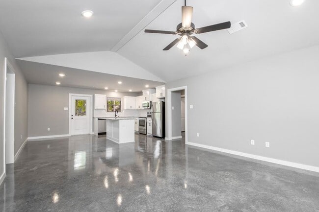
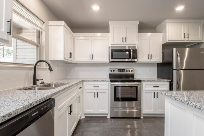
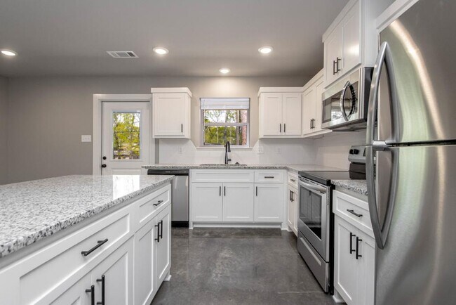
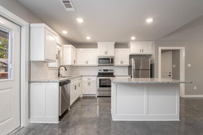
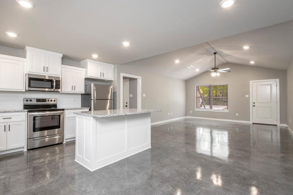
MOVE IN January 15!!! Open for showings starting Jan 9th. Built in 2019!!! 1 Tennant!!!! 3 bedroom, 2 bathroom, with a split floor plan. 2 car garage. Located within walking distance of Clinton Elementary school and quick access to the freeway! This home has trendy finishes with stained concrete, granite countertops, and gray tones. This rare find won't last long! Fully fenced back yard!! *Refrigerator and microwave included. **Pets with a $500 non refundable deposit ***Please note that if you're interested our application requires a household monthly salary to be 3 times the monthly rent. Everyone over 18 will need to complete a credit/background check at your expense ($35) and a copy of everyone's driver's license or ID.
106 Hemlock Ave is a house located in Pulaski County and the 72120 ZIP Code. This area is served by the Pulaski County Special attendance zone.
* Price shown is base rent. Excludes user-selected optional fees and variable or usage-based fees and required charges due at or prior to move-in or at move-out. Price, availability, fees, and any applicable rent special are subject to change without notice.
* Square footage definitions vary. Displayed square footage is approximate.
House Features
Dishwasher
Microwave
Refrigerator
Disposal
- Dishwasher
- Disposal
- Microwave
- Refrigerator
Contact
- Listed by Noah Treat
- Phone Number
- Contact
Location
Get Directions
Amenities
- Dishwasher
- Disposal
- Microwave
- Refrigerator
Jacksonville/Sherwood is a wooded area about 15 miles north of Little Rock. The community’s northern and western regions are mostly rural, but the town has a lot to offer. Jacksonville/ Sherwood has a diverse rental market with an abundance of affordable rental options. Modern amenities are located within and right outside of town, giving residents plenty of shopping and dining choices at places like McCain Mall and Lakewood Village. Outdoor recreation is abundant with forested parks and trails as well as the ones surrounding the Arkansas River. Commuters will appreciate Interstate 40 and Highway 167, which make traveling a breeze.
Learn more about living in Jacksonville/Sherwood
Education
| Colleges & Universities | Distance | ||
|---|---|---|---|
| Colleges & Universities | Distance | ||
| Drive: | 16 min | 8.7 mi | |
| Drive: | 16 min | 9.8 mi | |
| Drive: | 19 min | 11.6 mi | |
| Drive: | 23 min | 14.6 mi |
106 Hemlock Ave is within 16 minutes or 8.7 miles from Pulaski Technical College. It is also near Philander Smith College and Univ. of Ark. Medical Scis..
Schools


Public Elementary School
Grades PK-5
567 Students
Attendance Zone
Public Middle School
Grades 6-8
1,122 Students
Attendance Zone
Public High School
Grades 9-12
1,017 Students
Attendance Zone
Private Elementary, Middle & High School
Grades PK-12
268 Students
Nearby
Private Elementary School
Grades PK-6
121 Students
Nearby
School data provided by
 The GreatSchools Rating helps parents compare schools within a state based on a variety of school quality indicators and provides a helpful picture of how effectively each school serves all of its students. Ratings are on a scale of 1 (below average) to 10 (above average) and can include test scores, college readiness, academic progress, advanced courses, equity, discipline and attendance data. We also advise parents to visit schools, consider other information on school performance and programs, and consider family needs as part of the school selection process.
View GreatSchools Rating Methodology
Data provided by GreatSchools.org © 2025. All rights reserved.
View GreatSchools Rating Methodology
Data provided by GreatSchools.org © 2025. All rights reserved.
Transportation options available in Sherwood include Main St & Bishop Lindsey Ave, located 7.4 miles from 106 Hemlock Ave. 106 Hemlock Ave is near Bill and Hillary Clinton Ntl/Adams Field, located 12.7 miles or 20 minutes away.
| Transit / Subway | Distance | ||
|---|---|---|---|
| Transit / Subway | Distance | ||
| Drive: | 12 min | 7.4 mi | |
| Drive: | 12 min | 7.5 mi | |
| Drive: | 12 min | 7.7 mi | |
| Drive: | 12 min | 7.8 mi | |
| Drive: | 12 min | 7.8 mi |
| Commuter Rail | Distance | ||
|---|---|---|---|
| Commuter Rail | Distance | ||
|
|
Drive: | 15 min | 9.2 mi |
| Airports | Distance | ||
|---|---|---|---|
| Airports | Distance | ||
|
Bill and Hillary Clinton Ntl/Adams Field
|
Drive: | 20 min | 12.7 mi |
Time and distance from 106 Hemlock Ave.
| Shopping Centers | Distance | ||
|---|---|---|---|
| Shopping Centers | Distance | ||
| Walk: | 12 min | 0.6 mi | |
| Walk: | 16 min | 0.8 mi | |
| Walk: | 18 min | 0.9 mi |
106 Hemlock Ave has 3 shopping centers within 0.9 mile, which is about a 18-minute walk. The miles and minutes will be for the farthest away property.
| Parks and Recreation | Distance | ||
|---|---|---|---|
| Parks and Recreation | Distance | ||
|
Museum of Discovery
|
Drive: | 13 min | 8.5 mi |
|
Central Arkansas Nature Center
|
Drive: | 13 min | 8.6 mi |
|
Burns Park
|
Drive: | 15 min | 9.9 mi |
|
Central High School National Historic Site
|
Drive: | 18 min | 10.8 mi |
|
Little Rock Audubon Center
|
Drive: | 17 min | 11.4 mi |
106 Hemlock Ave has 5 parks within 11.4 miles, including Museum of Discovery, Central Arkansas Nature Center, and Burns Park.
| Hospitals | Distance | ||
|---|---|---|---|
| Hospitals | Distance | ||
| Drive: | 3 min | 1.6 mi | |
| Drive: | 8 min | 4.2 mi | |
| Drive: | 10 min | 6.4 mi |
106 Hemlock Ave has 3 hospitals within 6.4 miles, the nearest is St. Vincent Medical Center North which is 1.6 miles away and a 3 minute drive.
| Military Bases | Distance | ||
|---|---|---|---|
| Military Bases | Distance | ||
| Drive: | 19 min | 9.0 mi | |
| Drive: | 35 min | 12.2 mi | |
| Drive: | 41 min | 29.8 mi |
106 Hemlock Ave has 3 military bases within 29.8 miles, the nearest is Little Rock Air Force Base which is 9.0 miles away and a 19 minute drive.
You May Also Like
Similar Rentals Nearby


What Are Walk Score®, Transit Score®, and Bike Score® Ratings?
Walk Score® measures the walkability of any address. Transit Score® measures access to public transit. Bike Score® measures the bikeability of any address.
What is a Sound Score Rating?
A Sound Score Rating aggregates noise caused by vehicle traffic, airplane traffic and local sources
106 Hemlock Ave
Sherwood, AR 72120