

$3,250
/ Month
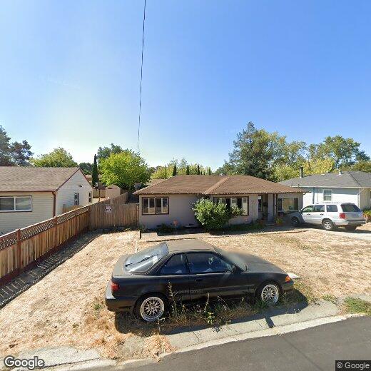
1051 St Andrews Dr
El Sobrante, CA 94803
Today
|
Edit
Favorites
415-710-6817
-
Bedrooms
3
-
Bathrooms
1
-
Square Feet
1,156 sq ft
-
Available
Available Now
Highlights
- Traditional Architecture
- Cooling Available
- Tile Flooring
- Heating Available
- Back Yard
- 1-Story Property
1051 St Andrews Dr

Favorites
About This Home
Available Now
The charming single-story home is located in a quiet neighborhood. 3 bedrooms,1 bath,good-sized living,Large yard,possible RV parking side yard. Close to school.
1051 St Andrews Dr is a house located in Contra Costa County and the 94803 ZIP Code. This area is served by the West Contra Costa Unified attendance zone.
* Price shown is base rent. Excludes user-selected optional fees and variable or usage-based fees and required charges due at or prior to move-in or at move-out. Price, availability, fees, and any applicable rent special are subject to change without notice.
* Square footage definitions vary. Displayed square footage is approximate.
Home Details
Home Type
Single Family Detached Home
Year Built
Built in 1949
Bedrooms and Bathrooms
1 Full Bathroom
3 Bedrooms
Flooring
Tile
Laminate
Home Design
Traditional Architecture
Composition Shingle Roof
Interior Spaces
1-Story Property
Listing and Financial Details
Assessor Parcel Number 4261140109
Lot Details
7,475 Sq Ft Lot
Back Yard
Utilities
Cooling Available
Heating Available
Community Details
Overview
No Home Owners Association
El Sobrante Subdivision
Contact
- Listed by Pa Pa Correa | Keenan Howard Realty,Inc.
- Phone Number
- Contact
-
Source
 Contra Costa Association of REALTORS®
Copyright © 2026 Bay East, CCAR, bridgeMLS. Based on information from Bay East and Contra Costa Association of REALTORS® and bridgeMLS. All data, including all measurements and calculations of area, is obtained from various sources and has not been, and will not be, verified by broker or MLS. All information should be independently reviewed and verified for accuracy. If a floor plan is included, the floor plan is for illustrative purposes only, and the actual dimensions and layout of the home may differ from the floor plan. Buyer is urged to make a detailed inspection of the property, and if any aspect of a floor plan is critical to the buyer's decision to purchase, buyer must conduct their own measurements and inspection. Properties may or may not be listed by the office/agent presenting the information.
Location
Get Directions
El Sobrante, which translates to “surplus” in Spanish, is a census designated place in Contra Costa County. Situated about 20 miles northwest of San Francisco, El Sobrante offers residents a quiet place to call home among tree-laden hills as well as convenience to one of the most dynamic cities in the United States.
While El Sobrante is a predominantly residential area, it is accessible to numerous retailers in the Pinole Vista Shopping Center and Hilltop Mall in addition to a variety of thrift stores and restaurants scattered along San Pablo Dam Road. El Sobrante residents enjoy the many outdoor recreational opportunities in their backyard, with Pinole Valley Park, Kennedy Grove Regional Recreation Area, Alvarado Park, Wildcat Canyon Regional Park, and San Pablo Reservoir Recreation Area all nearby. Easy access to the I-80 makes getting around from El Sobrante simple.
Learn more about living in El Sobrante
Education
| Colleges & Universities | Distance | ||
|---|---|---|---|
| Colleges & Universities | Distance | ||
| Drive: | 7 min | 2.9 mi | |
| Drive: | 21 min | 12.2 mi | |
| Drive: | 24 min | 13.2 mi | |
| Drive: | 26 min | 14.8 mi |
1051 St Andrews Dr is within 7 minutes or 2.9 miles from Contra Costa College. It is also near UC Berkeley and Berkeley City College.
Schools


Public Elementary School
Grades K-6
404 Students
Attendance Zone
Public Elementary School
Grades K-5
270 Students
Nearby
Public Middle School
Grades 6-8
401 Students
Attendance Zone
Public High School
Grades 9-12
1,237 Students
Attendance Zone
Private Elementary, Middle & High School
Grades 4-12
23 Students
Nearby
Private Elementary, Middle & High School
Grades K-12
196 Students
Nearby
Private Elementary, Middle & High School
Grades PK-12
Nearby
School data provided by
 The GreatSchools Rating helps parents compare schools within a state based on a variety of school quality indicators and provides a helpful picture of how effectively each school serves all of its students. Ratings are on a scale of 1 (below average) to 10 (above average) and can include test scores, college readiness, academic progress, advanced courses, equity, discipline and attendance data. We also advise parents to visit schools, consider other information on school performance and programs, and consider family needs as part of the school selection process.
View GreatSchools Rating Methodology
Data provided by GreatSchools.org © 2026. All rights reserved.
View GreatSchools Rating Methodology
Data provided by GreatSchools.org © 2026. All rights reserved.
Transportation options available in El Sobrante include El Cerrito Del Norte, located 6.2 miles from 1051 St Andrews Dr. 1051 St Andrews Dr is near Metro Oakland International, located 25.2 miles or 35 minutes away, and San Francisco International, located 32.8 miles or 48 minutes away.
| Transit / Subway | Distance | ||
|---|---|---|---|
| Transit / Subway | Distance | ||
|
|
Drive: | 11 min | 6.2 mi |
|
|
Drive: | 11 min | 6.2 mi |
|
|
Drive: | 12 min | 6.4 mi |
|
|
Drive: | 14 min | 8.1 mi |
|
|
Drive: | 19 min | 11.6 mi |
| Commuter Rail | Distance | ||
|---|---|---|---|
| Commuter Rail | Distance | ||
| Drive: | 12 min | 6.7 mi | |
|
|
Drive: | 16 min | 10.8 mi |
|
|
Drive: | 18 min | 12.6 mi |
|
|
Drive: | 22 min | 14.4 mi |
| Drive: | 27 min | 16.6 mi |
| Airports | Distance | ||
|---|---|---|---|
| Airports | Distance | ||
|
Metro Oakland International
|
Drive: | 35 min | 25.2 mi |
|
San Francisco International
|
Drive: | 48 min | 32.8 mi |
Time and distance from 1051 St Andrews Dr.
| Shopping Centers | Distance | ||
|---|---|---|---|
| Shopping Centers | Distance | ||
| Walk: | 16 min | 0.8 mi | |
| Walk: | 19 min | 1.0 mi | |
| Drive: | 4 min | 1.4 mi |
1051 St Andrews Dr has 3 shopping centers within 1.4 miles, which is about a 4-minute drive. The miles and minutes will be for the farthest away property.
| Parks and Recreation | Distance | ||
|---|---|---|---|
| Parks and Recreation | Distance | ||
|
Sobrante Ridge Regional Preserve
|
Drive: | 8 min | 3.0 mi |
|
Kennedy Grove Regional Recreation Area
|
Drive: | 10 min | 4.0 mi |
|
Ohlone Wilderness
|
Drive: | 9 min | 4.4 mi |
|
Point Pinole Regional Shoreline
|
Drive: | 9 min | 4.4 mi |
|
Wildcat Canyon Regional Park
|
Drive: | 17 min | 8.6 mi |
1051 St Andrews Dr has 5 parks within 8.6 miles, including Sobrante Ridge Regional Preserve, Ohlone Wilderness, and Kennedy Grove Regional Recreation Area.
| Hospitals | Distance | ||
|---|---|---|---|
| Hospitals | Distance | ||
| Drive: | 19 min | 12.8 mi | |
| Drive: | 19 min | 13.3 mi | |
| Drive: | 23 min | 13.8 mi |
1051 St Andrews Dr has 3 hospitals within 13.8 miles, the nearest is Adventist Health Vallejo which is 12.8 miles away and a 19 minute drive.
| Military Bases | Distance | ||
|---|---|---|---|
| Military Bases | Distance | ||
| Drive: | 8 min | 3.8 mi | |
| Drive: | 16 min | 8.7 mi | |
| Drive: | 24 min | 14.2 mi |
1051 St Andrews Dr has 3 military bases within 14.2 miles, the nearest is Armory West Contra Costa which is 3.8 miles away and a 8 minute drive.
You May Also Like
Similar Rentals Nearby


What Are Walk Score®, Transit Score®, and Bike Score® Ratings?
Walk Score® measures the walkability of any address. Transit Score® measures access to public transit. Bike Score® measures the bikeability of any address.
What is a Sound Score Rating?
A Sound Score Rating aggregates noise caused by vehicle traffic, airplane traffic and local sources
1051 St Andrews Dr
El Sobrante, CA 94803