1048 Leo Way
Oakland, CA 94611
-
Bedrooms
4
-
Bathrooms
2
-
Square Feet
1,947 sq ft
-
Available
Available Aug 15
Highlight
- Pets Allowed

About This Home
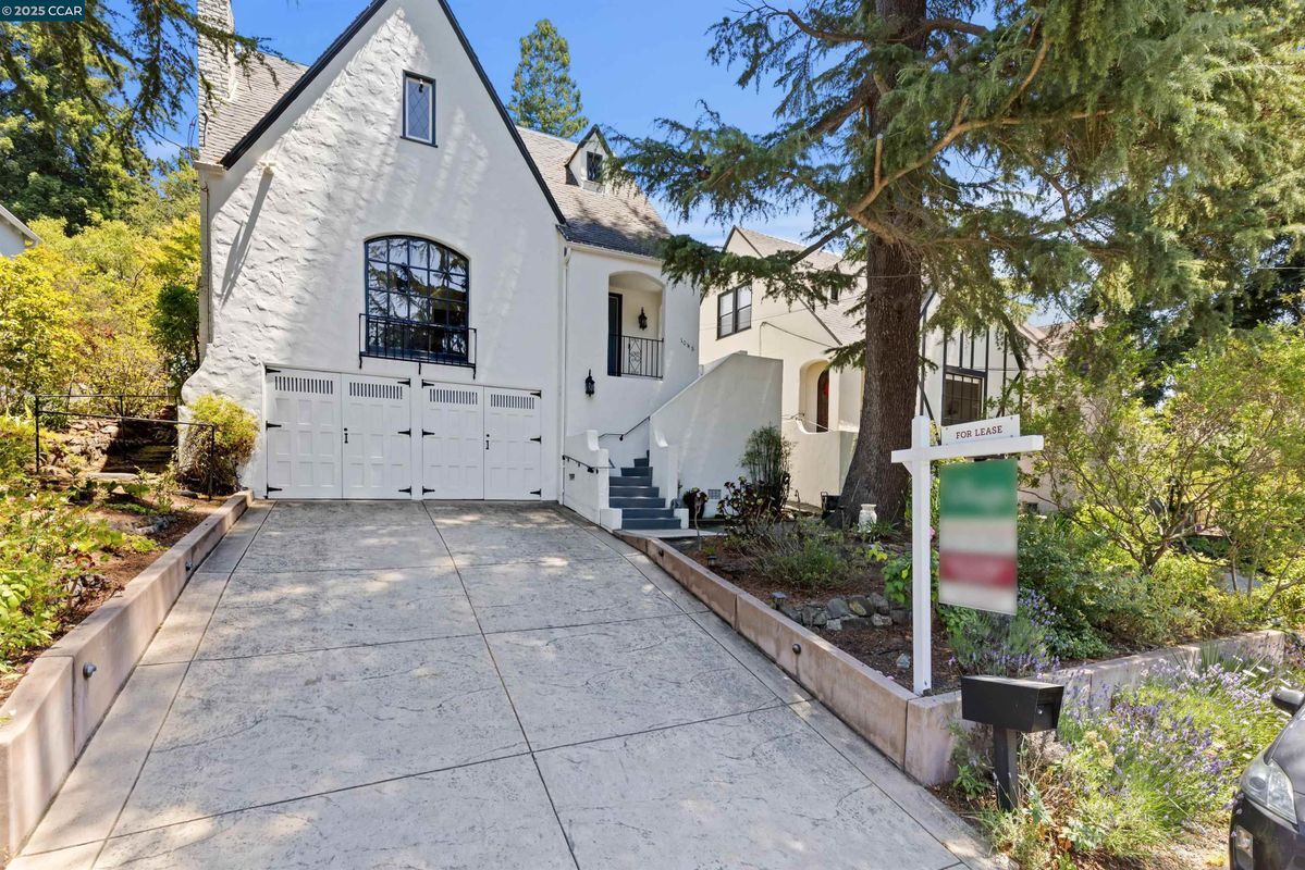
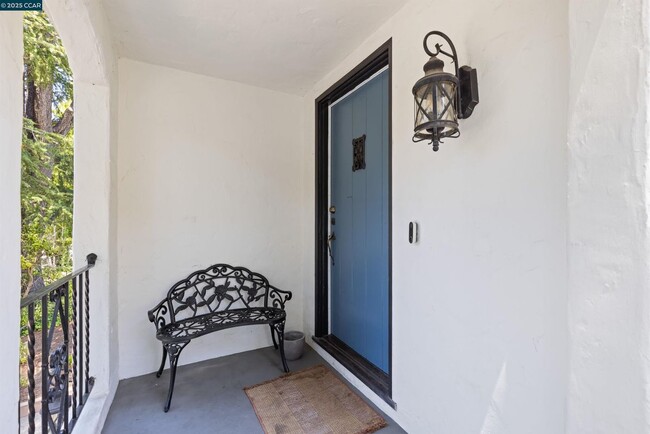
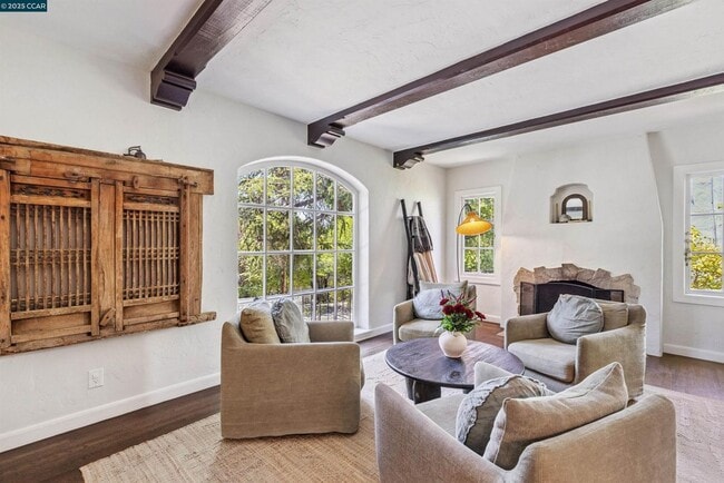
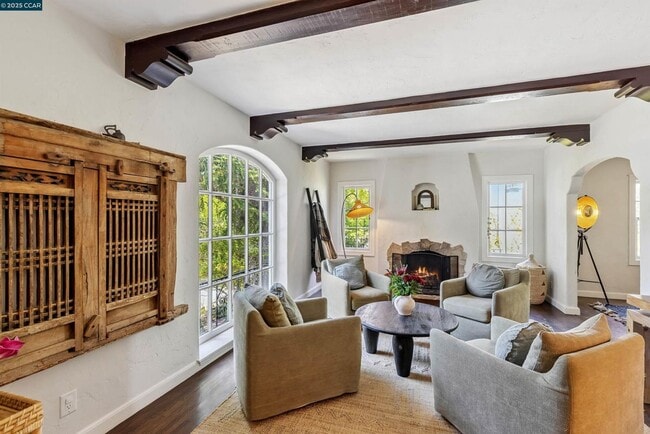
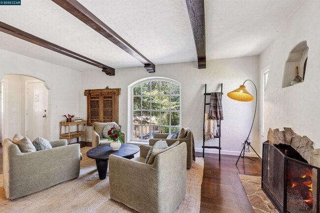
Storybook retreat in one of Oakland’s most beloved & neighborly communities! Just a short stroll to the boutiques, cafés & restaurants of Montclair Village & minutes to gourmet shopping at famed Broadway Terrace Village Market, College Ave, Rockridge & BART—this beautifully updated Tudor offers timeless elegance & modern livability in an unbeatable location. Graceful archways, gleaming natural light and thoughtful details throughout. The living room is a true showpiece, with a dramatic arched picture window, exposed beam ceiling & a central fireplace flanked by charming casement windows. The updated kitchen features stone countertops, a center island, five-burner gas range, French door refrigerator & a sweet breakfast nook. Step out to the stunning backyard offering a lush escape w/ multiple outdoor living spaces: a sunny deck for dining & grilling, grassy lawn for play, an upper terrace with arbor and built-in seating—perfect for evening wine under the stars. Downstairs enjoy flexible finished space ideal for a home office or bonus room with private side door access. Also downstairs, interior laundry & access to the two-car garage. Set on a tree-lined street with friendly neighbors this home is just minutes from top-rated schools, Montclair Park, Lake Temescal and commutes.
Unique Features
- OutdoorArea
1048 Leo Way is an apartment community located in Alameda County and the 94611 ZIP Code.
Features
Washer/Dryer
Air Conditioning
Dishwasher
Refrigerator
- Washer/Dryer
- Air Conditioning
- Dishwasher
- Disposal
- Refrigerator
- Renters Insurance Program
Fees and Policies
The fees below are based on community-supplied data and may exclude additional fees and utilities.
- Dogs Allowed
-
Fees not specified
- Cats Allowed
-
Fees not specified
- Parking
-
Other--Assigned Parking
Details
Lease Options
-
12 Months
Contact
- Phone Number
- Website View Property Website
- Contact
-
Source

- Washer/Dryer
- Air Conditioning
- Dishwasher
- Disposal
- Refrigerator
- Renters Insurance Program
- OutdoorArea
Northeast Oakland Hills is a lush area about five miles from the heart of Oakland and 12 miles east of San Francisco. Interstates 580 and 80 make commuting to the Bay Area a breeze. Hidden residential neighborhoods are tucked among Northeast Oakland’s wooded landscape. The rental options are situated along the borders of town and consist of apartments, houses, and condos. Large nature preserves like Joaquin Miller Park and Shepherd Canyon Park provide outdoor recreation in town while even larger state parks surround the area as well. Many of the dining and shopping options are situated a bit outside of town off Lakeshore Avenue and Grand Avenue.
Learn more about living in Northeast Oakland Hills| Colleges & Universities | Distance | ||
|---|---|---|---|
| Colleges & Universities | Distance | ||
| Drive: | 9 min | 3.4 mi | |
| Drive: | 10 min | 3.9 mi | |
| Drive: | 11 min | 4.3 mi | |
| Drive: | 9 min | 6.1 mi |
Transportation options available in Oakland include Rockridge Station, located 2.3 miles from 1048 Leo Way. 1048 Leo Way is near Metro Oakland International, located 12.1 miles or 18 minutes away, and San Francisco International, located 25.7 miles or 39 minutes away.
| Transit / Subway | Distance | ||
|---|---|---|---|
| Transit / Subway | Distance | ||
|
|
Drive: | 4 min | 2.3 mi |
|
|
Drive: | 5 min | 3.8 mi |
|
|
Drive: | 9 min | 4.1 mi |
|
|
Drive: | 12 min | 4.3 mi |
|
|
Drive: | 8 min | 5.7 mi |
| Commuter Rail | Distance | ||
|---|---|---|---|
| Commuter Rail | Distance | ||
|
|
Drive: | 10 min | 5.1 mi |
|
|
Drive: | 10 min | 6.9 mi |
|
|
Drive: | 14 min | 8.8 mi |
| Drive: | 20 min | 13.2 mi | |
| Drive: | 21 min | 14.5 mi |
| Airports | Distance | ||
|---|---|---|---|
| Airports | Distance | ||
|
Metro Oakland International
|
Drive: | 18 min | 12.1 mi |
|
San Francisco International
|
Drive: | 39 min | 25.7 mi |
Time and distance from 1048 Leo Way.
| Shopping Centers | Distance | ||
|---|---|---|---|
| Shopping Centers | Distance | ||
| Walk: | 15 min | 0.8 mi | |
| Drive: | 3 min | 1.2 mi | |
| Drive: | 4 min | 1.5 mi |
| Parks and Recreation | Distance | ||
|---|---|---|---|
| Parks and Recreation | Distance | ||
|
Oyster Bay Regional Shoreline
|
Drive: | 3 min | 1.2 mi |
|
Temescal Regional Park
|
Drive: | 4 min | 1.9 mi |
|
Huckleberry Botanic Regional Preserve
|
Drive: | 6 min | 2.4 mi |
|
Sibley Volcanic Regional Preserve
|
Drive: | 7 min | 2.7 mi |
|
Morcom Rose Garden
|
Drive: | 8 min | 3.7 mi |
| Hospitals | Distance | ||
|---|---|---|---|
| Hospitals | Distance | ||
| Drive: | 6 min | 2.7 mi | |
| Drive: | 7 min | 2.9 mi | |
| Drive: | 6 min | 3.5 mi |
| Military Bases | Distance | ||
|---|---|---|---|
| Military Bases | Distance | ||
| Drive: | 17 min | 8.6 mi | |
| Drive: | 18 min | 9.6 mi |
You May Also Like
What Are Walk Score®, Transit Score®, and Bike Score® Ratings?
Walk Score® measures the walkability of any address. Transit Score® measures access to public transit. Bike Score® measures the bikeability of any address.
What is a Sound Score Rating?
A Sound Score Rating aggregates noise caused by vehicle traffic, airplane traffic and local sources

1048 Leo Way
Oakland, CA 94611