

$7,750 / Month
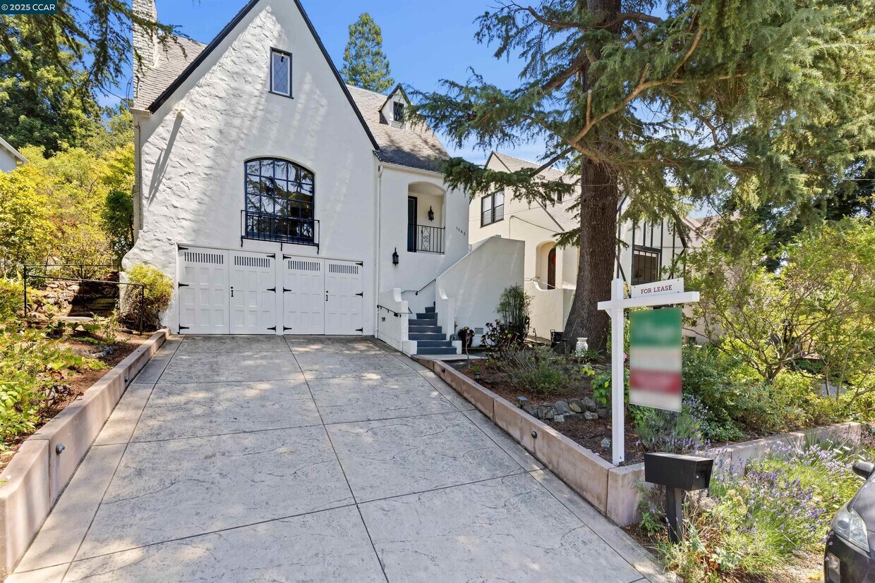
1048 Leo Way
Oakland, CA 94611
Today
Favorites
510-816-0706
-
Bedrooms
4
-
Bathrooms
2
-
Square Feet
1,947 sq ft
-
Available
Available Jul 18
Highlights
- Wood Flooring
- Tudor Architecture
- 2 Car Direct Access Garage
- No Cooling
- Forced Air Heating System
1048 Leo Way

Favorites
About This Home
Available Jul 18
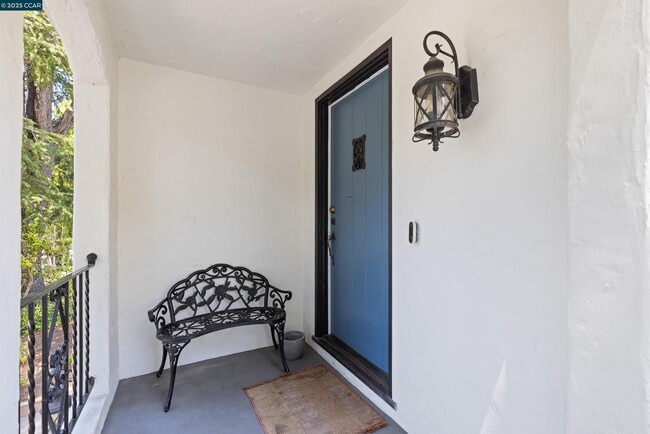
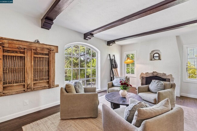
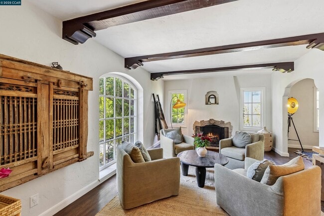
Storybook retreat in one of Oakland’s most beloved & neighborly communities! Just a short stroll to the boutiques,cafés & restaurants of Montclair Village & minutes to gourmet shopping at famed Broadway Terrace Village Market & College Ave/Rockridge/BART—this beautifully updated Tudor offers timeless elegance & modern livability in an unbeatable location. Graceful archways,gleaming natural light and thoughtful details throughout. The living room is a true showpiece,with a dramatic arched picture window,exposed beam ceiling & a central fireplace flanked by charming casement windows. The updated kitchen features stone countertops,a center island,five-burner gas range,French door refrigerator & a sweet breakfast nook. Step out to the stunning backyard offering a lush escape w/ multiple outdoor living spaces: a sunny deck for dining & grilling,grassy lawn for play,an upper terrace with arbor and built-in seating—perfect for evening wine under the stars. Downstairs enjoy flexible finished space ideal for a home office or bonus room with private side door access. Also downstairs,interior laundry & access to the two-car garage. Set on a tree-lined street with friendly neighbors this home is just minutes from top-rated schools,Montclair Park,Lake Temescal and commutes.
1048 Leo Way is a house located in Alameda County and the 94611 ZIP Code. This area is served by the Oakland Unified attendance zone.
* Price shown is base rent and may not include non-optional fees and utilities.
Price, availability, fees, and any applicable rent special are subject to change without notice.
* Square footage definitions vary. Displayed square footage is approximate.
Home Details
Home Type
Single Family Detached Home
Year Built
Built in 1931
Bedrooms and Bathrooms
2 Full Bathrooms
4 Bedrooms
Home Design
Tudor Architecture
Composition Shingle Roof
Stucco
Interior Spaces
Living Room with Fireplace
Wood Flooring
3-Story Property
Kitchen
Gas Range
Dishwasher
Laundry
Dryer
Washer
Listing and Financial Details
Assessor Parcel Number 48G7404311
Lot Details
5,063 Sq Ft Lot
Parking
2 Car Direct Access Garage
Utilities
No Cooling
Forced Air Heating System
Community Details
Overview
No Home Owners Association
Lower Montclair Subdivision
Contact
- Listed by Alexis Thompson | Village Associates Real Estate
- Phone Number
- Contact
-
Source
 Contra Costa Association of REALTORS®
Copyright © 2025 Bay East, CCAR, bridgeMLS. Based on information from Bay East and Contra Costa Association of REALTORS® and bridgeMLS. All data, including all measurements and calculations of area, is obtained from various sources and has not been, and will not be, verified by broker or MLS. All information should be independently reviewed and verified for accuracy. If a floor plan is included, the floor plan is for illustrative purposes only, and the actual dimensions and layout of the home may differ from the floor plan. Buyer is urged to make a detailed inspection of the property, and if any aspect of a floor plan is critical to the buyer's decision to purchase, buyer must conduct their own measurements and inspection. Properties may or may not be listed by the office/agent presenting the information.
Location
Get Directions
Northeast Oakland Hills is a lush area about five miles from the heart of Oakland and 12 miles east of San Francisco. Interstates 580 and 80 make commuting to the Bay Area a breeze. Hidden residential neighborhoods are tucked among Northeast Oakland’s wooded landscape. The rental options are situated along the borders of town and consist of apartments, houses, and condos. Large nature preserves like Joaquin Miller Park and Shepherd Canyon Park provide outdoor recreation in town while even larger state parks surround the area as well. Many of the dining and shopping options are situated a bit outside of town off Lakeshore Avenue and Grand Avenue.
Learn more about living in Northeast Oakland Hills
Education
| Colleges & Universities | Distance | ||
|---|---|---|---|
| Colleges & Universities | Distance | ||
| Drive: | 9 min | 3.4 mi | |
| Drive: | 10 min | 3.9 mi | |
| Drive: | 11 min | 4.3 mi | |
| Drive: | 9 min | 6.1 mi |
1048 Leo Way is within 9 minutes or 3.4 miles from Samuel Merritt University. It is also near UC Berkeley and Berkeley City College.
Schools


Public Elementary School
Grades K-5
383 Students
Attendance Zone
Public Elementary School
Grades K-5
270 Students
Nearby
Public Middle School
Grades 6-8
642 Students
Attendance Zone
Public High School
Grades 9-12
1,590 Students
Attendance Zone
Private Elementary, Middle & High School
Grades 1-12
Nearby
Private Elementary School
Grades K-5
103 Students
Nearby
Private Elementary & Middle School
Grades PK-8
237 Students
Nearby
School data provided by
 The GreatSchools Rating helps parents compare schools within a state based on a variety of school quality indicators and provides a helpful picture of how effectively each school serves all of its students. Ratings are on a scale of 1 (below average) to 10 (above average) and can include test scores, college readiness, academic progress, advanced courses, equity, discipline and attendance data. We also advise parents to visit schools, consider other information on school performance and programs, and consider family needs as part of the school selection process.
View GreatSchools Rating Methodology
Data provided by GreatSchools.org © 2025. All rights reserved.
View GreatSchools Rating Methodology
Data provided by GreatSchools.org © 2025. All rights reserved.
Transportation options available in Oakland include Rockridge Station, located 2.3 miles from 1048 Leo Way. 1048 Leo Way is near Metro Oakland International, located 12.1 miles or 18 minutes away, and San Francisco International, located 25.7 miles or 39 minutes away.
| Transit / Subway | Distance | ||
|---|---|---|---|
| Transit / Subway | Distance | ||
|
|
Drive: | 4 min | 2.3 mi |
|
|
Drive: | 5 min | 3.8 mi |
|
|
Drive: | 9 min | 4.1 mi |
|
|
Drive: | 12 min | 4.3 mi |
|
|
Drive: | 8 min | 5.7 mi |
| Commuter Rail | Distance | ||
|---|---|---|---|
| Commuter Rail | Distance | ||
|
|
Drive: | 10 min | 5.1 mi |
|
|
Drive: | 10 min | 6.9 mi |
|
|
Drive: | 14 min | 8.8 mi |
| Drive: | 20 min | 13.2 mi | |
| Drive: | 21 min | 14.5 mi |
| Airports | Distance | ||
|---|---|---|---|
| Airports | Distance | ||
|
Metro Oakland International
|
Drive: | 18 min | 12.1 mi |
|
San Francisco International
|
Drive: | 39 min | 25.7 mi |
Time and distance from 1048 Leo Way.
| Shopping Centers | Distance | ||
|---|---|---|---|
| Shopping Centers | Distance | ||
| Walk: | 15 min | 0.8 mi | |
| Drive: | 3 min | 1.2 mi | |
| Drive: | 4 min | 1.5 mi |
1048 Leo Way has 3 shopping centers within 1.5 miles, which is about a 4-minute walk. The miles and minutes will be for the farthest away property.
| Parks and Recreation | Distance | ||
|---|---|---|---|
| Parks and Recreation | Distance | ||
|
Oyster Bay Regional Shoreline
|
Drive: | 3 min | 1.2 mi |
|
Temescal Regional Park
|
Drive: | 4 min | 1.9 mi |
|
Huckleberry Botanic Regional Preserve
|
Drive: | 6 min | 2.4 mi |
|
Sibley Volcanic Regional Preserve
|
Drive: | 7 min | 2.7 mi |
|
Morcom Rose Garden
|
Drive: | 8 min | 3.7 mi |
1048 Leo Way has 5 parks within 3.7 miles, including Oyster Bay Regional Shoreline, Temescal Regional Park, and Huckleberry Botanic Regional Preserve.
| Hospitals | Distance | ||
|---|---|---|---|
| Hospitals | Distance | ||
| Drive: | 6 min | 2.7 mi | |
| Drive: | 7 min | 2.9 mi | |
| Drive: | 6 min | 3.5 mi |
1048 Leo Way has 3 hospitals within 3.5 miles, the nearest is Alta Bates Summit Medical Center - Alta Bates Campus which is 2.7 miles away and a 6 minute drive.
| Military Bases | Distance | ||
|---|---|---|---|
| Military Bases | Distance | ||
| Drive: | 17 min | 8.6 mi | |
| Drive: | 18 min | 9.6 mi |
1048 Leo Way is 8.6 miles from Oakland Army Base, and is convenient to other military bases, including Alameda/US Naval Air Station Alameda.
You May Also Like
Similar Rentals Nearby


What Are Walk Score®, Transit Score®, and Bike Score® Ratings?
Walk Score® measures the walkability of any address. Transit Score® measures access to public transit. Bike Score® measures the bikeability of any address.
What is a Sound Score Rating?
A Sound Score Rating aggregates noise caused by vehicle traffic, airplane traffic and local sources

1048 Leo Way
Oakland, CA 94611