
$3,495
/ Month
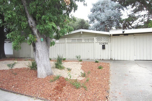
10454 Sterling Blvd
Cupertino, CA 95014
2 Weeks Ago
|
Edit
Favorites
10454 Sterling Blvd

Favorites
Check Back Soon for Upcoming Availability
| Beds | Baths | Average SF |
|---|---|---|
| 3 Bedrooms 3 Bedrooms 3 Br | 2 Baths 2 Baths 2 Ba | 1,127 SF |
About This Property
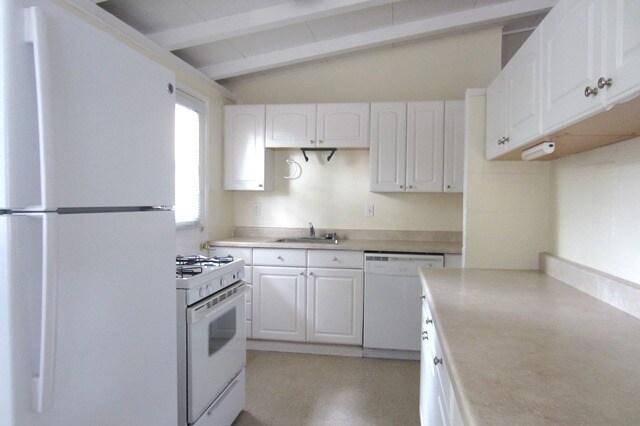
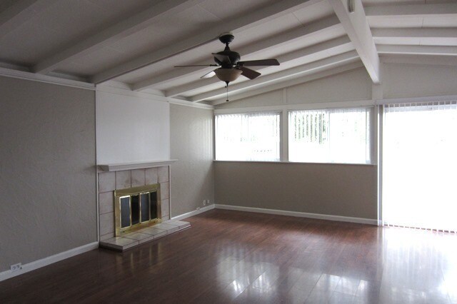
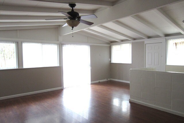
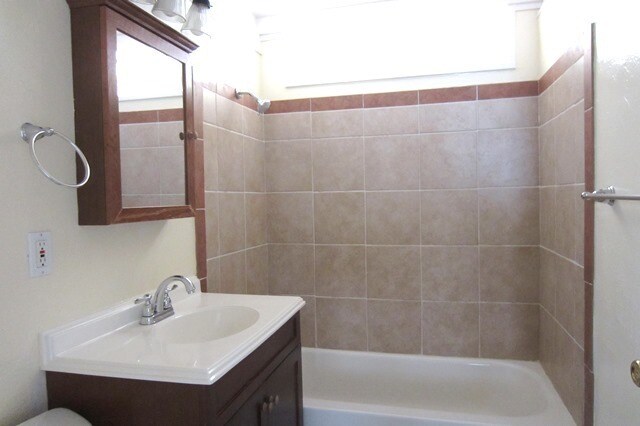
10454 Sterling Blvd, Cupertino, CA 95014 (Sterling/Crabtree) Cute single family home in a desirable neighborhood with 3 bedrooms, 2 bathrooms, and a 1 car detached garage. The home has fresh paint, wood laminate flooring, new window coverings, dual pane windows, and new landscaping in the front yard. The kitchen includes white counters with formica countertops, refrigerator, gas stove/oven, and a dishwasher. The bathrooms have been recently upgraded with new tile flooring and newer tile shower enclosures. The home has a 1 car detached garage with washer/dryer hookups. The backyard is large and unlandscaped. One year lease required. Small pet considered with additional deposit. Gardening included with the rent. Schools - Sedgwick Elementary, Hyde Junior High, and Cupertino High School. Cal BRE# 01512831
10454 Sterling Blvd is a house located in Santa Clara County and the 95014 ZIP Code. This area is served by the Cupertino Union School District attendance zone.
House Features
- Dishwasher
10454 Sterling Blvd,
Cupertino,
CA
95014
Located in the heart of Silicon Valley, Cupertino combines suburban living with technological advancement. The city, home to Apple Inc.'s distinctive Apple Park headquarters, features tree-lined streets and rolling foothills. Housing includes apartments, townhouses, and single-family homes throughout various neighborhoods. Current rental data shows one-bedroom apartments averaging $3,138 per month, while three-bedroom units average $4,994.
The city features De Anza College, set on a 112-acre campus. Outdoor enthusiasts can explore the Stevens Creek Trail, which winds through McClellan Ranch Park and Blackberry Farm. Memorial Park hosts community events and concerts throughout the year. The Cupertino Library serves as a central resource for residents, ranking as Santa Clara County's most active branch. The area's history dates back to Spanish exploration, when the region was named after Arroyo San José de Cupertino, a creek named in honor of Saint Joseph of Cupertino.
Learn more about living in CupertinoBelow are rent ranges for similar nearby apartments
Amenities
- Dishwasher
Education
| Colleges & Universities | Distance | ||
|---|---|---|---|
| Colleges & Universities | Distance | ||
| Drive: | 10 min | 3.5 mi | |
| Drive: | 10 min | 4.9 mi | |
| Drive: | 12 min | 4.9 mi | |
| Drive: | 14 min | 6.1 mi |
10454 Sterling Blvd is within 10 minutes or 3.5 miles from De Anza College. It is also near San Jose City College and Santa Clara University.
Schools


Public Elementary School
Grades K-5
407 Students
Attendance Zone
Public Middle School
Grades 6-8
800 Students
Attendance Zone
Public High School
Grades 9-12
1,800 Students
Attendance Zone
Private Elementary & Middle School
Grades PK-8
Nearby
Private Elementary & Middle School
Grades PK-8
252 Students
Nearby
Private High School
Grades 9-12
1,752 Students
Nearby
School data provided by
 The GreatSchools Rating helps parents compare schools within a state based on a variety of school quality indicators and provides a helpful picture of how effectively each school serves all of its students. Ratings are on a scale of 1 (below average) to 10 (above average) and can include test scores, college readiness, academic progress, advanced courses, equity, discipline and attendance data. We also advise parents to visit schools, consider other information on school performance and programs, and consider family needs as part of the school selection process.
View GreatSchools Rating Methodology
Data provided by GreatSchools.org © 2026. All rights reserved.
View GreatSchools Rating Methodology
Data provided by GreatSchools.org © 2026. All rights reserved.
Transportation options available in Cupertino include Campbell Station, located 4.9 miles from 10454 Sterling Blvd. 10454 Sterling Blvd is near Norman Y Mineta San Jose International, located 6.5 miles or 14 minutes away, and San Francisco International, located 33.9 miles or 44 minutes away.
| Transit / Subway | Distance | ||
|---|---|---|---|
| Transit / Subway | Distance | ||
| Drive: | 11 min | 4.9 mi | |
| Drive: | 12 min | 5.0 mi | |
| Drive: | 10 min | 5.6 mi | |
| Drive: | 9 min | 5.6 mi | |
|
|
Drive: | 10 min | 6.2 mi |
| Commuter Rail | Distance | ||
|---|---|---|---|
| Commuter Rail | Distance | ||
| Drive: | 9 min | 4.9 mi | |
| Drive: | 12 min | 5.8 mi | |
| Drive: | 13 min | 5.9 mi | |
| Drive: | 13 min | 6.1 mi | |
| Drive: | 12 min | 7.0 mi |
| Airports | Distance | ||
|---|---|---|---|
| Airports | Distance | ||
|
Norman Y Mineta San Jose International
|
Drive: | 14 min | 6.5 mi |
|
San Francisco International
|
Drive: | 44 min | 33.9 mi |
Walkability Near 10454 Sterling Blvd Cupertino, CA 95014
Getting Around
 What do Walkability, Transit, Drivability, and Bikeability mean?
Walkability measures the walking distance to day-to-day needs.
Transit measures access to public transportation.
Drivability measures congestion, parking availability, and access to major roads.
Bikeability measures the suitability for cycling.
How It Works
What do Walkability, Transit, Drivability, and Bikeability mean?
Walkability measures the walking distance to day-to-day needs.
Transit measures access to public transportation.
Drivability measures congestion, parking availability, and access to major roads.
Bikeability measures the suitability for cycling.
How It Works
Moderately Walkable
Walkability
60
/ 100
Limited Public Transit
Transit
30
/ 100
Exceptionally Drivable
Drivability
100
/ 100
Fairly Bikeable
Bikeability
50
/ 100
Scores provided by
-
Soundscore™
-
/ 100
Traffic
-Airport
-Businesses
-Scores provided by
HowLoud What is a Sound Score Rating? A Sound Score Rating aggregates noise caused by vehicle traffic, airplane traffic and local sources. How It WorksTime and distance from 10454 Sterling Blvd.
| Shopping Centers | Distance | ||
|---|---|---|---|
| Shopping Centers | Distance | ||
| Walk: | 13 min | 0.7 mi | |
| Drive: | 4 min | 1.1 mi | |
| Drive: | 4 min | 1.2 mi |
10454 Sterling Blvd has 3 shopping centers within 1.2 miles, which is about a 4-minute drive. The miles and minutes will be for the farthest away property.
| Parks and Recreation | Distance | ||
|---|---|---|---|
| Parks and Recreation | Distance | ||
|
Fujitsu Planetarium
|
Drive: | 10 min | 3.5 mi |
|
McClellan Ranch Park
|
Drive: | 12 min | 4.4 mi |
|
John D. Morgan Park
|
Drive: | 10 min | 4.6 mi |
|
Jack Fischer Park
|
Drive: | 11 min | 4.7 mi |
|
Orchard City Green
|
Drive: | 11 min | 6.0 mi |
10454 Sterling Blvd has 5 parks within 6.0 miles, including Fujitsu Planetarium, McClellan Ranch Park, and John D. Morgan Park.
| Hospitals | Distance | ||
|---|---|---|---|
| Hospitals | Distance | ||
| Drive: | 5 min | 2.3 mi | |
| Drive: | 6 min | 2.4 mi | |
| Drive: | 8 min | 4.6 mi |
10454 Sterling Blvd has 3 hospitals within 4.6 miles, the nearest is Kaiser Foundation Hospital - Santa Clara which is 2.3 miles away and a 5 minute drive.
| Military Bases | Distance | ||
|---|---|---|---|
| Military Bases | Distance | ||
| Drive: | 19 min | 10.9 mi |
10454 Sterling Blvd is 10.9 miles and a 19 minute drive from Ames Research Center.
You May Also Like
Similar Rentals Nearby


What Are Walk Score®, Transit Score®, and Bike Score® Ratings?
Walk Score® measures the walkability of any address. Transit Score® measures access to public transit. Bike Score® measures the bikeability of any address.
What is a Sound Score Rating?
A Sound Score Rating aggregates noise caused by vehicle traffic, airplane traffic and local sources.

10454 Sterling Blvd
Cupertino, CA 95014