
Venue Residences
3688 Overland Ave,
Los Angeles, CA 90034
$2,495 - $6,995
Studio - 2 Beds


Located 2 blocks from Beverly Hills, this 6 Unit Apartment Building consisting of 1 and 2 bedroom apartments is conveniently located to Cedars-Sinai Medical Center and centrally located to Kaiser Permanente, Farmer’s Market, The Grove, Beverly Hills, Century City, Downtown LA, Santa Monica and LAX. Conveniently located to a variety of markets, restaurants, and numerous places of worship. Building and all units are non-smoking.
1033 S Holt Ave is an apartment community located in Los Angeles County and the 90035 ZIP Code. This area is served by the Los Angeles Unified attendance zone.
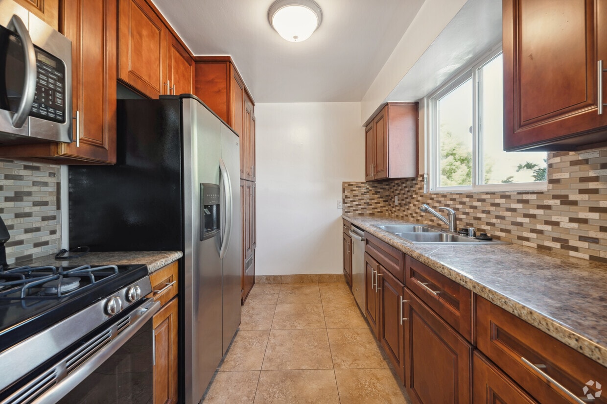
Unique Features
Air Conditioning
Dishwasher
High Speed Internet Access
Hardwood Floors
Granite Countertops
Microwave
Refrigerator
Wi-Fi
There are numerous nicknames for Los Angeles, just as there are various vibes within this sprawling city. Between rugged mountains and sandy shorelines, a laid-back surf culture and a high-powered commercial district, and food trucks and some of the world’s top-rated restaurants, Los Angeles features diversity in every aspect possible. Somehow, all the pieces of this city fit together seamlessly, making Los Angeles the unique destination we know and love. From Rodeo Drive and Beverly Hills to Hollywood and Chinatown, there is the perfect neighborhood for everyone in Los Angeles.
From celebrity sightings to unbeatable shopping destinations, Los Angeles is hard to beat. Enjoy a hike in the Santa Monica Mountains, Griffith Park, or Topanga State Park, enjoy the famous entertainment at Universal Studios Hollywood, see the stars along the legendary Hollywood Walk of Fame, or stop into the Los Angeles County Museum of Art.
Learn more about living in Los Angeles| Colleges & Universities | Distance | ||
|---|---|---|---|
| Colleges & Universities | Distance | ||
| Drive: | 13 min | 5.0 mi | |
| Drive: | 12 min | 5.4 mi | |
| Drive: | 10 min | 5.5 mi | |
| Drive: | 11 min | 5.8 mi |


Transportation options available in Los Angeles include La Cienega/Jefferson, located 2.5 miles from 1033 S Holt Ave. 1033 S Holt Ave is near Los Angeles International, located 9.6 miles or 19 minutes away, and Bob Hope, located 13.8 miles or 26 minutes away.
| Transit / Subway | Distance | ||
|---|---|---|---|
| Transit / Subway | Distance | ||
|
|
Drive: | 6 min | 2.5 mi |
|
|
Drive: | 6 min | 2.6 mi |
|
|
Drive: | 6 min | 3.3 mi |
|
|
Drive: | 8 min | 4.0 mi |
|
|
Drive: | 9 min | 4.9 mi |
| Commuter Rail | Distance | ||
|---|---|---|---|
| Commuter Rail | Distance | ||
|
|
Drive: | 17 min | 9.0 mi |
|
|
Drive: | 19 min | 9.3 mi |
|
|
Drive: | 20 min | 11.4 mi |
|
|
Drive: | 23 min | 11.7 mi |
|
|
Drive: | 24 min | 12.7 mi |
| Airports | Distance | ||
|---|---|---|---|
| Airports | Distance | ||
|
Los Angeles International
|
Drive: | 19 min | 9.6 mi |
|
Bob Hope
|
Drive: | 26 min | 13.8 mi |
Time and distance from 1033 S Holt Ave.
| Shopping Centers | Distance | ||
|---|---|---|---|
| Shopping Centers | Distance | ||
| Walk: | 3 min | 0.2 mi | |
| Walk: | 7 min | 0.4 mi | |
| Walk: | 10 min | 0.5 mi |
| Parks and Recreation | Distance | ||
|---|---|---|---|
| Parks and Recreation | Distance | ||
|
Zimmer Children's Museum
|
Drive: | 3 min | 1.2 mi |
|
La Brea Tar Pits
|
Drive: | 3 min | 1.7 mi |
|
Virginia Robinson Gardens
|
Drive: | 9 min | 3.7 mi |
|
Kenneth Hahn State Recreation Area
|
Drive: | 12 min | 4.6 mi |
|
Mathias Botanical Garden
|
Drive: | 11 min | 4.9 mi |
| Hospitals | Distance | ||
|---|---|---|---|
| Hospitals | Distance | ||
| Walk: | 19 min | 1.0 mi | |
| Drive: | 2 min | 1.1 mi | |
| Drive: | 3 min | 1.4 mi |
| Military Bases | Distance | ||
|---|---|---|---|
| Military Bases | Distance | ||
| Drive: | 19 min | 11.2 mi |
What Are Walk Score®, Transit Score®, and Bike Score® Ratings?
Walk Score® measures the walkability of any address. Transit Score® measures access to public transit. Bike Score® measures the bikeability of any address.
What is a Sound Score Rating?
A Sound Score Rating aggregates noise caused by vehicle traffic, airplane traffic and local sources
1033 S Holt Ave
Los Angeles, CA 90035


