
$925 / Month
1030 N Raymond Ave Unit 1A
Pasadena, CA 91103
2 Weeks Ago
Favorites
1030 N Raymond Ave Unit 1A

Favorites
Check Back Soon for Upcoming Availability
| Beds | Baths | Average SF |
|---|---|---|
| 1 Bedroom 1 Bedroom 1 Br | 1 Bath 1 Bath 1 Ba | — |
About This Property
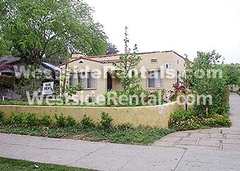
**********GREAT APARTMENT, CLOSE TO FREEWAYS******* Not Specified units in 21-unit building. 1-car No Parking. SPANISH STYLE APARTMENT. STOVE REFRIGERATOR MINIBLINDS CLOSE TO OLD PASADENA AND PASADENA CITY COLLEGE. PLEASE CALL FOR MORE INFOMATION
1030 N Raymond Ave is an apartment community located in Los Angeles County and the 91103 ZIP Code.
Features
- Laundry Facilities
- Patio
Location
Get Directions
Near the San Gabriel Mountains, where I-210 meets State Route 134 and becomes the Foothill Freeway, rests Pasadena’s Garfield Heights neighborhood. Primarily a residential area, Garfield Heights contains a number of markets, churches, and temples. Garfield Heights residents enjoy access to neighboring parks such as La Pintoresca Park and City of Pasadena Robinson Park.
There are a host of amenities located within close proximity to Garfield Heights. Among the many amenities are the Rose Bowl Stadium, Kidspace Children’s Museum, Norton Simon Museum, Brookside Golf and Country Club, Pasadena Convention Center, Paseo Colorado, and the California Institute of Technology.
Served by several Metro Local lines and Pasadena Transit routes, getting around Garfield Height is a breeze.
Learn more about living in Garfield HeightsBelow are rent ranges for similar nearby apartments
Amenities
- Laundry Facilities
- Patio
Education
| Colleges & Universities | Distance | ||
|---|---|---|---|
| Colleges & Universities | Distance | ||
| Drive: | 3 min | 1.6 mi | |
| Drive: | 7 min | 3.1 mi | |
| Drive: | 9 min | 3.2 mi | |
| Drive: | 8 min | 3.3 mi |
1030 N Raymond Ave Unit 1A is within 3 minutes or 1.6 miles from Fuller Theological Seminary. It is also near Pasadena City College and Caltech.
Transportation options available in Pasadena include Memorial Park Station, located 1.4 miles from 1030 N Raymond Ave Unit 1A. 1030 N Raymond Ave Unit 1A is near Bob Hope, located 17.1 miles or 23 minutes away, and Los Angeles International, located 25.6 miles or 41 minutes away.
| Transit / Subway | Distance | ||
|---|---|---|---|
| Transit / Subway | Distance | ||
|
|
Drive: | 4 min | 1.4 mi |
|
|
Drive: | 5 min | 1.7 mi |
|
|
Drive: | 3 min | 1.9 mi |
|
|
Drive: | 5 min | 2.3 mi |
|
|
Drive: | 5 min | 2.8 mi |
| Commuter Rail | Distance | ||
|---|---|---|---|
| Commuter Rail | Distance | ||
|
|
Drive: | 13 min | 9.6 mi |
|
|
Drive: | 18 min | 10.6 mi |
|
|
Drive: | 18 min | 10.7 mi |
|
|
Drive: | 21 min | 11.9 mi |
| Drive: | 22 min | 14.7 mi |
| Airports | Distance | ||
|---|---|---|---|
| Airports | Distance | ||
|
Bob Hope
|
Drive: | 23 min | 17.1 mi |
|
Los Angeles International
|
Drive: | 41 min | 25.6 mi |
Time and distance from 1030 N Raymond Ave Unit 1A.
| Shopping Centers | Distance | ||
|---|---|---|---|
| Shopping Centers | Distance | ||
| Walk: | 8 min | 0.4 mi | |
| Walk: | 14 min | 0.8 mi | |
| Walk: | 16 min | 0.8 mi |
1030 N Raymond Ave Unit 1A has 3 shopping centers within 0.8 mile, which is about a 16-minute walk. The miles and minutes will be for the farthest away property.
| Parks and Recreation | Distance | ||
|---|---|---|---|
| Parks and Recreation | Distance | ||
|
Kidspace Children's Museum
|
Drive: | 4 min | 1.6 mi |
|
Jet Propulsion Laboratory
|
Drive: | 4 min | 2.7 mi |
|
Eaton Canyon Nature Center
|
Drive: | 8 min | 4.0 mi |
|
Huntington Botanical Gardens
|
Drive: | 10 min | 4.4 mi |
|
Descanso Gardens
|
Drive: | 10 min | 6.1 mi |
1030 N Raymond Ave Unit 1A has 5 parks within 6.1 miles, including Kidspace Children's Museum, Jet Propulsion Laboratory, and Eaton Canyon Nature Center.
| Hospitals | Distance | ||
|---|---|---|---|
| Hospitals | Distance | ||
| Drive: | 4 min | 2.1 mi | |
| Drive: | 8 min | 4.8 mi | |
| Drive: | 9 min | 6.1 mi |
1030 N Raymond Ave Unit 1A has 3 hospitals within 6.1 miles, the nearest is Huntington Memorial Hospital which is 2.1 miles away and a 4 minute drive.
| Military Bases | Distance | ||
|---|---|---|---|
| Military Bases | Distance | ||
| Drive: | 38 min | 27.2 mi | |
| Drive: | 48 min | 30.7 mi |
1030 N Raymond Ave Unit 1A is 27.2 miles from Los Angeles Air Force Base, and is convenient to other military bases, including Los Alamitos Army Airfield.
You May Also Like
Similar Rentals Nearby


What Are Walk Score®, Transit Score®, and Bike Score® Ratings?
Walk Score® measures the walkability of any address. Transit Score® measures access to public transit. Bike Score® measures the bikeability of any address.
What is a Sound Score Rating?
A Sound Score Rating aggregates noise caused by vehicle traffic, airplane traffic and local sources
1030 N Raymond Ave
Pasadena, CA 91103