
$2,200
/ Month
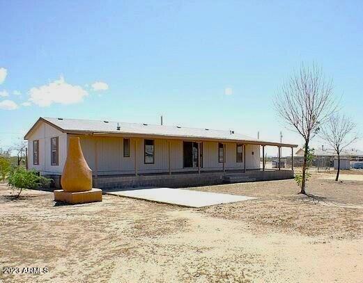
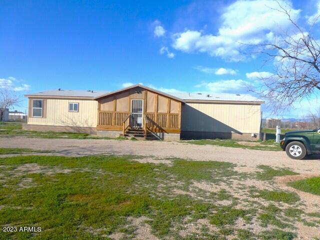
10240 E Lind Rd
San Tan Valley, AZ 85143
Favorites
10240 E Lind Rd

Favorites
Check Back Soon for Upcoming Availability
| Beds | Baths | Average SF |
|---|---|---|
| 5 Bedrooms 5 Bedrooms 5 Br | 3 Baths 3 Baths 3 Ba | 1,905 SF |
10240 E Lind Rd,
San Tan Valley,
AZ
85143
Situated about 30 miles southeast of Phoenix, Superstition Vistas is a community in progress. Superstition Vistas is an oasis of opportunity, striving to combine the best of urban and rural living while maintaining wide open spaces. Recreational destinations abound near this community on the rise, including San Tan Mountains Regional Park, Freestone Park, and Usery Mountain Regional Park. The Arizona Renaissance Festival is also located on the cusp of Superstition Vistas, just off of Superstition Freeway.
Learn more about living in Superstition VistasBelow are rent ranges for similar nearby apartments
Education
| Colleges & Universities | Distance | ||
|---|---|---|---|
| Colleges & Universities | Distance | ||
| Drive: | 47 min | 19.8 mi | |
| Drive: | 47 min | 20.2 mi | |
| Drive: | 55 min | 27.9 mi | |
| Drive: | 72 min | 35.4 mi |
10240 E Lind Rd is within 47 minutes or 19.8 miles from Arizona State Univ., Polytech. It is also near Chandler-Gilbert C.C., Mesa and A.T. Still Univ. AZ.
Schools


Public Elementary & Middle School
Grades PK-8
503 Students
Attendance Zone
Public Middle & High School
Grades 6-12
1,308 Students
Attendance Zone
Private Elementary, Middle & High School
Grades K-12
Nearby
Private Elementary, Middle & High School
Grades PK-12
97 Students
Nearby
School data provided by
 The GreatSchools Rating helps parents compare schools within a state based on a variety of school quality indicators and provides a helpful picture of how effectively each school serves all of its students. Ratings are on a scale of 1 (below average) to 10 (above average) and can include test scores, college readiness, academic progress, advanced courses, equity, discipline and attendance data. We also advise parents to visit schools, consider other information on school performance and programs, and consider family needs as part of the school selection process.
View GreatSchools Rating Methodology
Data provided by GreatSchools.org © 2026. All rights reserved.
View GreatSchools Rating Methodology
Data provided by GreatSchools.org © 2026. All rights reserved.
Walkability Near 10240 E Lind Rd San Tan Valley, AZ 85143
Getting Around
 What do Walkability, Transit, Drivability, and Bikeability mean?
Walkability measures the walking distance to day-to-day needs.
Transit measures access to public transportation.
Drivability measures congestion, parking availability, and access to major roads.
Bikeability measures the suitability for cycling.
How It Works
What do Walkability, Transit, Drivability, and Bikeability mean?
Walkability measures the walking distance to day-to-day needs.
Transit measures access to public transportation.
Drivability measures congestion, parking availability, and access to major roads.
Bikeability measures the suitability for cycling.
How It Works
Not Walkable
Walkability
0
/ 100
Exceptionally Drivable
Drivability
100
/ 100
Somewhat Bikeable
Bikeability
30
/ 100
Scores provided by
-
Soundscore™
-
/ 100
Traffic
-Airport
-Businesses
-Scores provided by
HowLoud What is a Sound Score Rating? A Sound Score Rating aggregates noise caused by vehicle traffic, airplane traffic and local sources. How It WorksYou May Also Like
Similar Rentals Nearby


What Are Walk Score®, Transit Score®, and Bike Score® Ratings?
Walk Score® measures the walkability of any address. Transit Score® measures access to public transit. Bike Score® measures the bikeability of any address.
What is a Sound Score Rating?
A Sound Score Rating aggregates noise caused by vehicle traffic, airplane traffic and local sources.
10240 E Lind Rd
San Tan Valley, AZ 85143