

$795
/ Month
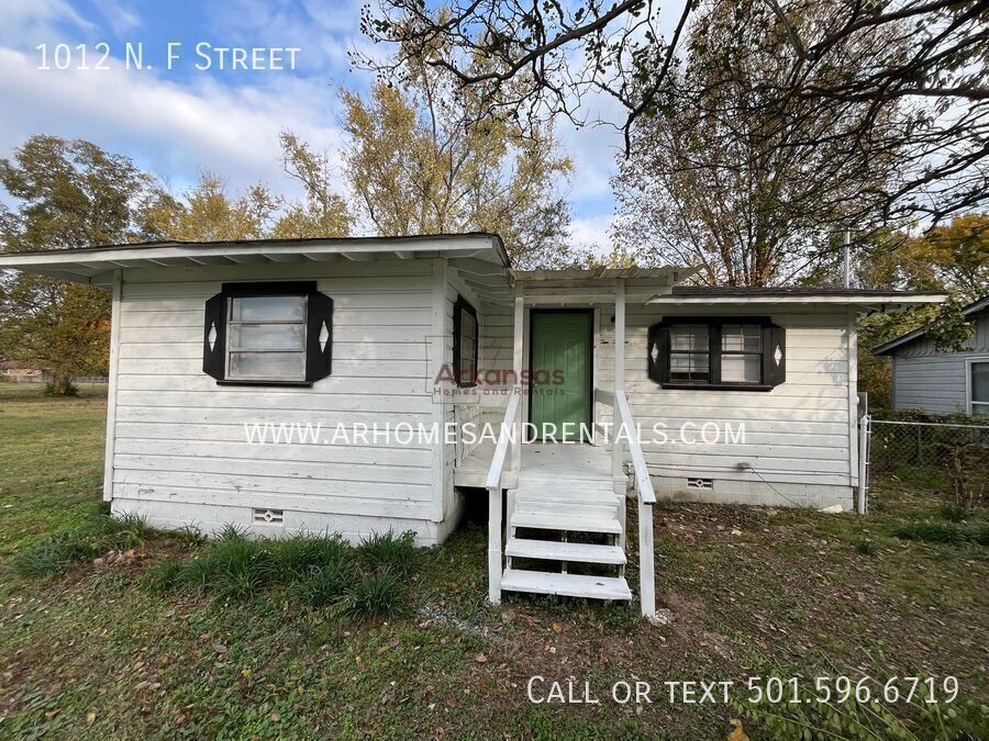
1012 F St
North Little Rock, AR 72114
Favorites
-
Bedrooms
2
-
Bathrooms
1
-
Square Feet
704 sq ft
1012 F St

Favorites
About This Home
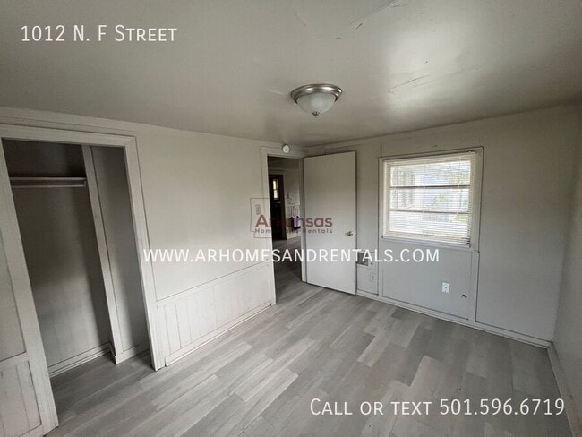
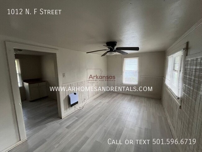
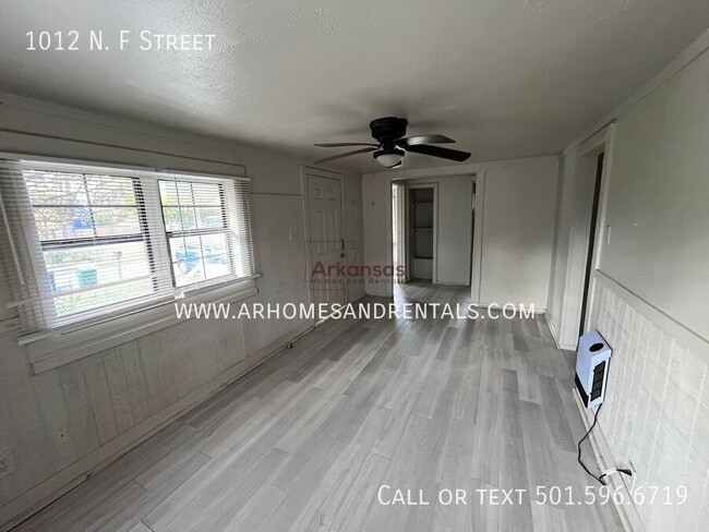
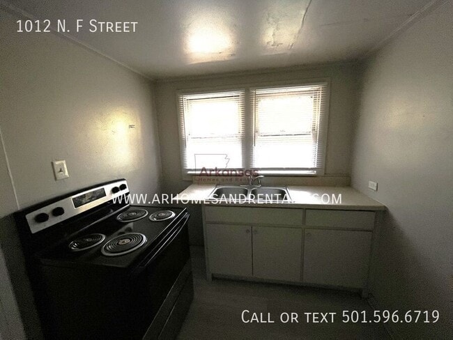
1012 N. F Street North Little Rock, AR 72114 ***1/2 Off First Month Rent!!!*** Don't miss out on the opportunity to make 1012 N. F Street your new home! Advertised rent reflects a 24 month lease. A 12 month lease is available for an additional $50 per month. Contact us today at: for more information and to schedule a tour! Apply online at: Features: ***1/2 Off First Month Rent!!!*** -2 Bedrooms -1 Bathroom -Ceiling fans -Stove -Off-street parking -Spacious yard -Washer and dryer connections -Porch -Fenced in backyard Electric Stove Electric Water Heater Fenced In Back Yard Heat Only Wall Heaters Electric Spacious Yard Washer And Dryer Connection
1012 F St is a house located in Pulaski County and the 72114 ZIP Code. This area is served by the North Little Rock School District attendance zone.
* Price shown is base rent. Excludes user-selected optional fees and variable or usage-based fees and required charges due at or prior to move-in or at move-out. Price, availability, fees, and any applicable rent special are subject to change without notice.
* Square footage definitions vary. Displayed square footage is approximate.
Fees and Policies
The fees listed below are community-provided and may exclude utilities or add-ons. All payments are made directly to the property and are non-refundable unless otherwise specified.
-
Dogs
-
Allowed
-
-
Cats
-
Allowed
-
Property Fee Disclaimer: Based on community-supplied data and independent market research. Subject to change without notice. May exclude fees for mandatory or optional services and usage-based utilities.
Contact
- Listed by Arkansas | Arkansas Homes and Rentals Investments, LLC
Location
Get Directions
North Little Rock sits on the north bank of the Arkansas River, directly across from the state capital, giving residents a city of their own with immediate access to a major metro area. The two cities share the iconic Big Dam Bridge, one of the longest pedestrian and bicycle bridges in the country built specifically for non-motorized travel, and the River Rail Streetcar, which connects both downtowns with a short, scenic ride. Originally called Argenta before incorporating as North Little Rock in 1917, the city carries that history proudly through its revitalized Argenta Historic District, where restored storefronts now house galleries, live theater, boutiques, and locally rooted restaurants. Burns Park, stretching over 1,700 acres, anchors the outdoor scene with golf courses, trails, tennis courts, and athletic fields. Neighborhoods like Park Hill and Lakewood offer distinct residential pockets within the city.
Learn more about living in North Little Rock
Education
| Colleges & Universities | Distance | ||
|---|---|---|---|
| Colleges & Universities | Distance | ||
| Drive: | 10 min | 5.0 mi | |
| Drive: | 15 min | 6.5 mi | |
| Drive: | 14 min | 6.7 mi | |
| Drive: | 18 min | 9.8 mi |
1012 F St is within 10 minutes or 5.0 miles from Philander Smith College. It is also near Pulaski Technical College and Univ. of Ark. Medical Scis..
Schools


Public Elementary School
Grades PK-5
241 Students
Attendance Zone
Public Middle School
Grades 6-8
1,026 Students
Attendance Zone
Public High School
Grades 9-12
1,615 Students
Attendance Zone
Private Elementary, Middle & High School
Grades PK-12
373 Students
Nearby
School data provided by
 The GreatSchools Rating helps parents compare schools within a state based on a variety of school quality indicators and provides a helpful picture of how effectively each school serves all of its students. Ratings are on a scale of 1 (below average) to 10 (above average) and can include test scores, college readiness, academic progress, advanced courses, equity, discipline and attendance data. We also advise parents to visit schools, consider other information on school performance and programs, and consider family needs as part of the school selection process.
View GreatSchools Rating Methodology
Data provided by GreatSchools.org © 2026. All rights reserved.
View GreatSchools Rating Methodology
Data provided by GreatSchools.org © 2026. All rights reserved.
Transportation options available in North Little Rock include Simmons Arena (To Lr), located 2.9 miles from 1012 F St. 1012 F St is near Bill and Hillary Clinton Ntl/Adams Field, located 9.0 miles or 14 minutes away.
| Transit / Subway | Distance | ||
|---|---|---|---|
| Transit / Subway | Distance | ||
| Drive: | 6 min | 2.9 mi | |
| Drive: | 6 min | 2.9 mi | |
| Drive: | 6 min | 2.9 mi | |
| Drive: | 6 min | 3.1 mi | |
| Drive: | 6 min | 3.1 mi |
| Commuter Rail | Distance | ||
|---|---|---|---|
| Commuter Rail | Distance | ||
|
|
Drive: | 9 min | 4.4 mi |
| Airports | Distance | ||
|---|---|---|---|
| Airports | Distance | ||
|
Bill and Hillary Clinton Ntl/Adams Field
|
Drive: | 14 min | 9.0 mi |
Getting Around
 What do Walkability, Transit, Drivability, and Bikeability mean?
Walkability measures the walking distance to day-to-day needs.
Transit measures access to public transportation.
Drivability measures congestion, parking availability, and access to major roads.
Bikeability measures the suitability for cycling.
How It Works
What do Walkability, Transit, Drivability, and Bikeability mean?
Walkability measures the walking distance to day-to-day needs.
Transit measures access to public transportation.
Drivability measures congestion, parking availability, and access to major roads.
Bikeability measures the suitability for cycling.
How It Works
Somewhat Walkable
Walkability
20
/ 100
Limited Public Transit
Transit
20
/ 100
Exceptionally Drivable
Drivability
90
/ 100
Fairly Bikeable
Bikeability
50
/ 100
Scores provided by
-
Soundscore™
-
/ 100
Traffic
-Airport
-Businesses
-Scores provided by
HowLoud What is a Sound Score Rating? A Sound Score Rating aggregates noise caused by vehicle traffic, airplane traffic and local sources. How It WorksTime and distance from 1012 F St.
| Shopping Centers | Distance | ||
|---|---|---|---|
| Shopping Centers | Distance | ||
| Drive: | 4 min | 1.4 mi | |
| Drive: | 3 min | 1.6 mi | |
| Drive: | 4 min | 1.9 mi |
1012 F St has 3 shopping centers within 1.9 miles, which is about a 4-minute drive. The miles and minutes will be for the farthest away property.
| Parks and Recreation | Distance | ||
|---|---|---|---|
| Parks and Recreation | Distance | ||
|
Museum of Discovery
|
Drive: | 8 min | 3.7 mi |
|
Central Arkansas Nature Center
|
Drive: | 8 min | 3.7 mi |
|
Central High School National Historic Site
|
Drive: | 12 min | 6.0 mi |
|
Little Rock Audubon Center
|
Drive: | 13 min | 7.1 mi |
|
Burns Park
|
Drive: | 14 min | 8.0 mi |
1012 F St has 5 parks within 8.0 miles, including Museum of Discovery, Central Arkansas Nature Center, and Central High School National Historic Site.
| Hospitals | Distance | ||
|---|---|---|---|
| Hospitals | Distance | ||
| Drive: | 9 min | 4.7 mi | |
| Drive: | 11 min | 5.1 mi | |
| Drive: | 12 min | 6.5 mi |
1012 F St has 3 hospitals within 6.5 miles, the nearest is Baptist Health Medical Center North Little Rock which is 4.7 miles away and a 9 minute drive.
| Military Bases | Distance | ||
|---|---|---|---|
| Military Bases | Distance | ||
| Drive: | 35 min | 16.3 mi | |
| Drive: | 30 min | 17.9 mi | |
| Drive: | 40 min | 27.8 mi |
1012 F St has 3 military bases within 27.8 miles, the nearest is Camp Joseph T. Robinson Hill which is 16.3 miles away and a 35 minute drive.
You May Also Like
Similar Rentals Nearby


What Are Walk Score®, Transit Score®, and Bike Score® Ratings?
Walk Score® measures the walkability of any address. Transit Score® measures access to public transit. Bike Score® measures the bikeability of any address.
What is a Sound Score Rating?
A Sound Score Rating aggregates noise caused by vehicle traffic, airplane traffic and local sources.
1012 F St
North Little Rock, AR 72114