$3,800
/ Month
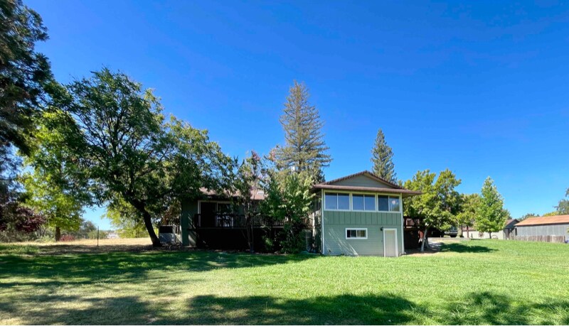
1 Mt Pleasant Rd
lincoln, CA 95648
2 Weeks Ago
|
Edit
Favorites
1 Mt Pleasant Rd

Favorites
Check Back Soon for Upcoming Availability
| Beds | Baths | Average SF |
|---|---|---|
| 3 Bedrooms 3 Bedrooms 3 Br | 2.5 Baths 2.5 Baths 2.5 Ba | 2,400 SF |
Fees and Policies
The fees listed below are community-provided and may exclude utilities or add-ons. All payments are made directly to the property and are non-refundable unless otherwise specified.
About This Property
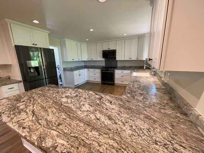
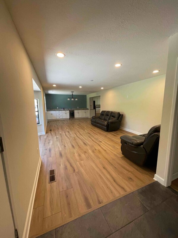
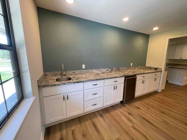
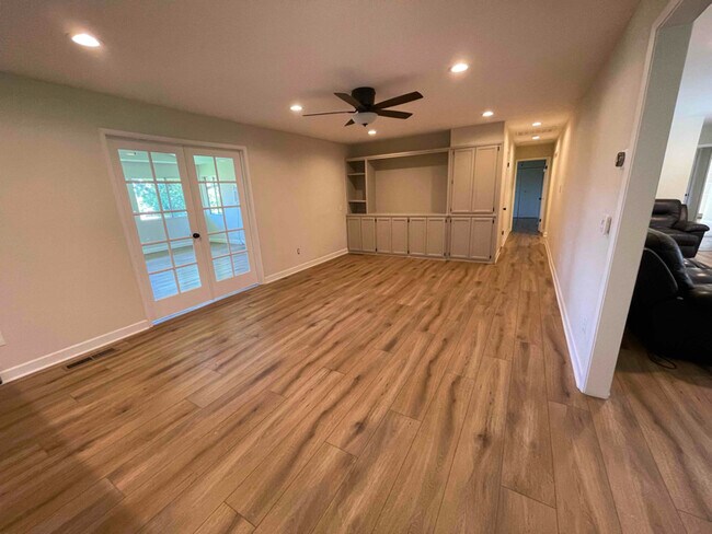
Property Id: 1539496 33 Beds | 2 1/2 Baths | 2,400 SF Bonus Sun Room Living room 3 Beds | 2 1/2 Baths | 2,400 SF Bonus Sun Room Living room | Dinning room with wet bar Sitting room with built in cabinets Home was fully remodeled in 2020 Large open Kitchen with Samsung appliances, farm sink, propane range, plenty of cabinet storage, peninsula with seating, and granite countertops. Laundry room/ mud room - hook up for washer and dryer (propane), freezer, and 1/2 bath LVP throughout entire house for easy cleaning AC/ Central Heat System installed 2023 Fenced and Gated with auto clicker 1 acre of lawn around home, small pond in back yard, covered patio, stamped concrete patio and side patio. Tenant Responsible for: Garbage Electricity Propane Lawn maintenance (lawnmower provided) No Smoking & No Animals Allowed (no exceptions, please don't ask) This property is situated on 23 acres, the property is currently being used to run cattle and will have regular farm/ranch equipment on the property.
1 Mt Pleasant Rd is a house located in Placer County and the 95648 ZIP Code. This area is served by the Western Placer Unified School District attendance zone.
House Features
Dishwasher
Microwave
Refrigerator
Disposal
- Dishwasher
- Disposal
- Microwave
- Oven
- Refrigerator
- Tile Floors
- Lawn
1 Mt Pleasant Rd,
lincoln,
CA
95648
Lincoln is a small city located about ten miles north of Roseville and thirty miles north of Sacramento. Primarily a residential suburb, much of the city’s landscape consists of low-key neighborhoods surrounding Lincoln Hills Golf Club. The cozy Downtown district along Lincoln Boulevard exhibits a classic small-town aesthetic, with locally-owned favorites like Awful Annie’s Country Harvest Bakery operating out of historic storefronts.
Small public parks dot the community, ensuring that virtually everyone has a tranquil greenspace within just a few blocks of home. The close proximity to Roseville allows you to easily take advantage of the more extensive shopping, dining, and entertainment options in the neighboring city, and the state capital is at your fingertips as well.
Learn more about living in Lincoln
Amenities
- Dishwasher
- Disposal
- Microwave
- Oven
- Refrigerator
- Tile Floors
- Lawn
Education
| Colleges & Universities | Distance | ||
|---|---|---|---|
| Colleges & Universities | Distance | ||
| Drive: | 29 min | 14.2 mi | |
| Drive: | 46 min | 26.8 mi | |
| Drive: | 53 min | 27.0 mi | |
| Drive: | 50 min | 29.5 mi |
1 Mt Pleasant Rd is within 29 minutes or 14.2 miles from Sierra College, Rocklin Campus. It is also near American River College and Folsom Lake College, Folsom.
Schools


Public Elementary School
Grades K-5
549 Students
Nearby
Public Elementary School
Grades K-5
442 Students
Nearby
Public Middle School
Grades 6-8
815 Students
Attendance Zone
Public High School
Grades 9-12
1,184 Students
Attendance Zone
Private Elementary & Middle School
Grades PK-8
78 Students
Nearby
Private Elementary, Middle & High School
Grades K-12
Nearby
Private Elementary, Middle & High School
Grades K-12
Nearby
School data provided by
 The GreatSchools Rating helps parents compare schools within a state based on a variety of school quality indicators and provides a helpful picture of how effectively each school serves all of its students. Ratings are on a scale of 1 (below average) to 10 (above average) and can include test scores, college readiness, academic progress, advanced courses, equity, discipline and attendance data. We also advise parents to visit schools, consider other information on school performance and programs, and consider family needs as part of the school selection process.
View GreatSchools Rating Methodology
Data provided by GreatSchools.org © 2026. All rights reserved.
View GreatSchools Rating Methodology
Data provided by GreatSchools.org © 2026. All rights reserved.
Walkability Near 1 Mt Pleasant Rd lincoln, CA 95648
Getting Around
 What do Walkability, Transit, Drivability, and Bikeability mean?
Walkability measures the walking distance to day-to-day needs.
Transit measures access to public transportation.
Drivability measures congestion, parking availability, and access to major roads.
Bikeability measures the suitability for cycling.
How It Works
What do Walkability, Transit, Drivability, and Bikeability mean?
Walkability measures the walking distance to day-to-day needs.
Transit measures access to public transportation.
Drivability measures congestion, parking availability, and access to major roads.
Bikeability measures the suitability for cycling.
How It Works
Not Walkable
Walkability
10
/ 100
Exceptionally Drivable
Drivability
100
/ 100
Somewhat Bikeable
Bikeability
20
/ 100
Scores provided by
-
Soundscore™
-
/ 100
Traffic
-Airport
-Businesses
-Scores provided by
HowLoud What is a Sound Score Rating? A Sound Score Rating aggregates noise caused by vehicle traffic, airplane traffic and local sources. How It WorksYou May Also Like
Similar Rentals Nearby
-
-
3 Beds$3,1054 Beds$3,280+Total Monthly PriceTotal Monthly Price NewPrices include base rent and required monthly fees of $60. Variable costs based on usage may apply.Base Rent:3 Beds$3,0454 Beds$3,220+Specials
Pets Allowed Fitness Center In Unit Washer & Dryer Clubhouse Stainless Steel Appliances
-
-
")
-
-

-

-

-

-


What Are Walk Score®, Transit Score®, and Bike Score® Ratings?
Walk Score® measures the walkability of any address. Transit Score® measures access to public transit. Bike Score® measures the bikeability of any address.
What is a Sound Score Rating?
A Sound Score Rating aggregates noise caused by vehicle traffic, airplane traffic and local sources.

1 Mt Pleasant Rd
lincoln, CA 95648