West Side Place

104 Proetz Ln, Nash, TX 75569

Share Listing
Favorites
West Side Place
Share Listing
Favorites

Highlights

  • Yard
  • Fenced Lot

About West Side Place

Find true Nash living at West Side Place. Situated in Nash's 75569 Zip code, moving here offers a variety of nearby attractions. Come by to see the available floorplan options. From amenities to location, the professional leasing staff is ready to help you find your new home. Come see West Side Place today.

West Side Place is an apartment community located in Bowie County and the 75569 ZIP Code. This area is served by the Texarkana Independent School District attendance zone.

Community Amenities

  • Maintenance on site
  • 24 Hour Access
  • Fenced Lot

Apartment Features

Air Conditioning

Washer/Dryer Hookup

High Speed Internet Access

Yard

  • High Speed Internet Access
  • Washer/Dryer Hookup
  • Air Conditioning
  • Smoke Free
  • Wheelchair Accessible (Rooms)
  • Oven
  • Range
  • Refrigerator
  • Yard
Location
104 Proetz Ln, Nash,
TX 75569
Get Directions
Education
Colleges & Universities Distance
Drive: 8 min 4.1 mi
Drive: 13 min 6.9 mi
Drive: 47 min 40.6 mi
West Side Place is within 8 minutes or 4.1 miles from Texarkana College. It is also near Texas A&M University Texarkana and UAHT.
Schools
Public Elementary School
Grades PK-5
Attendance Zone
Public Middle School
Grades 6-8
Attendance Zone
Public High School
Grades 9-12
Nearby
Public High School
Grades 9-12
Attendance Zone
Private Elementary, Middle & High School
Grades PK-12
Nearby
Private Elementary School
Grades PK-5
Nearby
Private Elementary, Middle & High School
Grades K-12
Nearby
Transportation

West Side Place is near Texarkana Regional-Webb Field, located 10.5 miles or 21 minutes away.

Commuter Rail Distance
Drive: 11 min 6.6 mi
Airports Distance
Airports Distance
Texarkana Regional-Webb Field
Drive: 21 min 10.5 mi

Walkability Near West Side Place

Getting Around
Somewhat Walkable
Walkability
30 / 100
Exceptionally Drivable
Drivability
100 / 100
Somewhat Bikeable
Bikeability
30 / 100

Scores provided by

What do Walkability, Transit, Drivability, and Bikeability mean? Walkability measures the walking distance to day-to-day needs. Transit measures access to public transportation. Drivability measures congestion, parking availability, and access to major roads. Bikeability measures the suitability for cycling. How It Works
Calm
Soundscore
81 / 100

Traffic

Active

Airport

Calm

Businesses

Calm

Scores provided by

HowLoud What is a Sound Score Rating? A Sound Score Rating aggregates noise caused by vehicle traffic, airplane traffic and local sources.
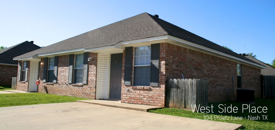
 How It Works
Points of Interest

Time and distance from West Side Place.

Shopping Centers Distance
Walk: 17 min 0.9 mi
Drive: 2 min 1.3 mi
Drive: 4 min 2.6 mi
West Side Place has 3 shopping centers within 2.6 miles, which is about a 4-minute drive. The miles and minutes will be for the farthest away property.
Parks and Recreation Distance
Kidtopia Park
Drive: 11 min 6.2 mi
Spring Lake Park
Drive: 12 min 6.3 mi
West Side Place has 2 parks within 6.3 miles, including Kidtopia Park, and Spring Lake Park.
Hospitals Distance
Hospitals Distance
Drive: 10 min 6.0 mi
Drive: 11 min 6.1 mi
Drive: 12 min 7.9 mi
West Side Place has 3 hospitals within 7.9 miles, the nearest is Wadley Regional Medical Center which is 6.0 miles away and a 10 minute drive.
Military Bases Distance
Drive: 30 min 16.4 mi
Drive: 126 min 93.5 mi
West Side Place is 16.4 miles from Red River Army Depot, and is convenient to other military bases, including Barksdale Air Force Base.