
Kinect at Southport
2301 Jefferson Blvd,
Sacramento, CA 95691
$1,550 - $3,044
Studio - 3 Beds

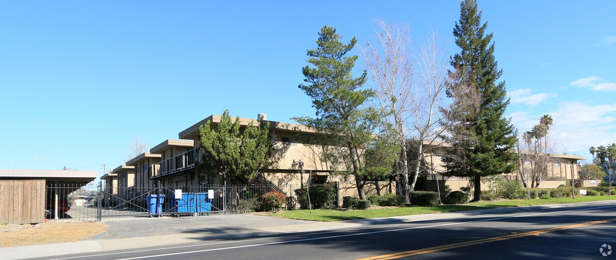
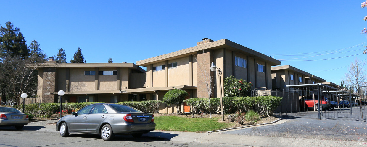
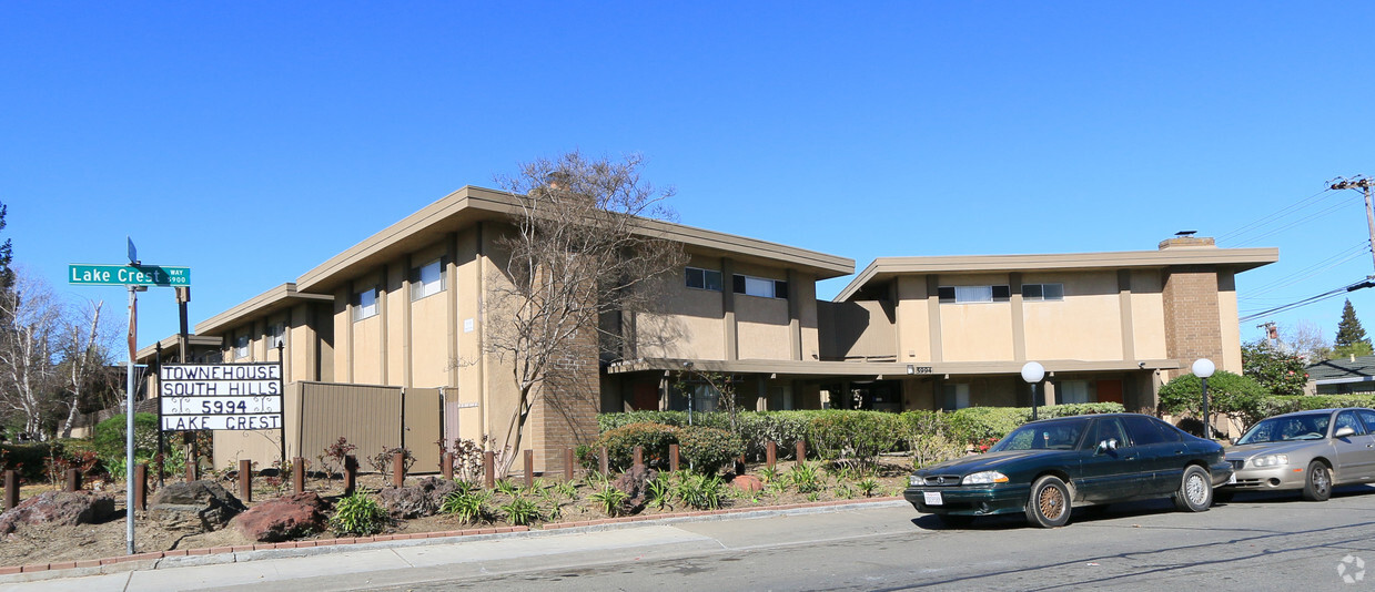
At Townhouse South Hills in Sacramento, you've discovered your new home. This community can be found at 5994 Lake Crest Way in Sacramento. The professional leasing staff is waiting to show you all that this community has in store. Come for a visit to see the available floorplan options. Experience a better way of living at Townhouse South Hills. Contact or drop by to talk about leasing your next apartment.
Townhouse South Hills is an apartment community located in Sacramento County and the 95822 ZIP Code. This area is served by the Sacramento City Unified School District attendance zone.
Pocketed within the Sacramento River, you’ll discover a cozy neighborhood known as Pocket-Greenhaven in Sacramento, California. Urban in population but suburban in atmosphere, Pocket-Greenhaven is a wonderful place to settle down. A family-friendly environment and tight-knit community await you in this scenic neighborhood.
Living on the riverfront awards you several perks such as waterfront parks! Enjoy scenic riverfront green space at Garcia Bend Park, boasting multi-use fields, a boat launch, and more. Interested in practicing your golf swing? No problem—Bing Maloney Golf Course is basically in your backyard.
Situated 10 miles southwest of Downtown Sacramento, Pocket-Greenhaven offers its residents proximity to wonderful historic attractions such as the California State Capitol Museum, the Sacramento Zoo, and the California State Railroad Museum. Enjoy access to local restaurants, bars, retailers, subway stations, theaters, and more.
Learn more about living in Pocket-GreenhavenCompare neighborhood and city base rent averages by bedroom.
| Pocket-Greenhaven | Sacramento, CA | |
|---|---|---|
| Studio | $729 | $1,501 |
| 1 Bedroom | $1,689 | $1,569 |
| 2 Bedrooms | $1,954 | $1,873 |
| 3 Bedrooms | $2,516 | $2,416 |
| Colleges & Universities | Distance | ||
|---|---|---|---|
| Colleges & Universities | Distance | ||
| Drive: | 7 min | 3.8 mi | |
| Drive: | 17 min | 9.5 mi | |
| Drive: | 16 min | 10.4 mi | |
| Drive: | 26 min | 19.5 mi |


Transportation options available in Sacramento include Fruitridge, located 2.4 miles from Townhouse South Hills. Townhouse South Hills is near Sacramento International, located 15.9 miles or 21 minutes away.
| Transit / Subway | Distance | ||
|---|---|---|---|
| Transit / Subway | Distance | ||
|
|
Drive: | 5 min | 2.4 mi |
|
|
Drive: | 9 min | 3.7 mi |
|
|
Drive: | 8 min | 4.1 mi |
|
|
Drive: | 8 min | 4.2 mi |
|
|
Drive: | 7 min | 4.3 mi |
| Commuter Rail | Distance | ||
|---|---|---|---|
| Commuter Rail | Distance | ||
| Drive: | 8 min | 5.6 mi | |
| Drive: | 23 min | 17.6 mi | |
|
|
Drive: | 34 min | 25.6 mi |
|
|
Drive: | 34 min | 27.7 mi |
|
|
Drive: | 53 min | 41.1 mi |
| Airports | Distance | ||
|---|---|---|---|
| Airports | Distance | ||
|
Sacramento International
|
Drive: | 21 min | 15.9 mi |
Scores provided by
Traffic
-Airport
-Businesses
-Scores provided by
HowLoud What is a Sound Score Rating? A Sound Score Rating aggregates noise caused by vehicle traffic, airplane traffic and local sources. How It WorksTime and distance from Townhouse South Hills.
| Shopping Centers | Distance | ||
|---|---|---|---|
| Shopping Centers | Distance | ||
| Walk: | 9 min | 0.5 mi | |
| Drive: | 4 min | 1.7 mi | |
| Drive: | 3 min | 1.8 mi |
| Parks and Recreation | Distance | ||
|---|---|---|---|
| Parks and Recreation | Distance | ||
|
Sacramento Zoo
|
Drive: | 4 min | 2.7 mi |
|
California Native Plant Demonstration Garden
|
Drive: | 8 min | 4.8 mi |
|
California State Capitol Museum
|
Drive: | 9 min | 5.8 mi |
|
Leland Stanford Mansion State Historic Park
|
Drive: | 9 min | 5.9 mi |
|
Sutter's Fort State Historical Monument
|
Drive: | 10 min | 7.4 mi |
| Hospitals | Distance | ||
|---|---|---|---|
| Hospitals | Distance | ||
| Drive: | 10 min | 7.2 mi | |
| Drive: | 11 min | 7.3 mi | |
| Drive: | 11 min | 7.4 mi |
| Military Bases | Distance | ||
|---|---|---|---|
| Military Bases | Distance | ||
| Drive: | 29 min | 17.3 mi | |
| Drive: | 57 min | 43.5 mi | |
| Drive: | 63 min | 50.3 mi |
What Are Walk Score®, Transit Score®, and Bike Score® Ratings?
Walk Score® measures the walkability of any address. Transit Score® measures access to public transit. Bike Score® measures the bikeability of any address.
What is a Sound Score Rating?
A Sound Score Rating aggregates noise caused by vehicle traffic, airplane traffic and local sources.
5994 Lake Crest Way
Sacramento, CA 95822


